
 Live Science Plus


Best Earth Images of the Month January 2013

Flashes from above

A line of severe storms, reaching from Pittsburgh to the Gulf Coast, is currently sweeping its way across the eastern United States. The system started rolling through the mid-South and parts of the Midwest yesterday (Jan. 29), and a satellite snapped a nighttime view of a lightning flash generated by the storms.
The Suomi NPP satellite, run jointly by NASA and the National Oceanic and Atmospheric Administration, flew over the satellite activity last night. Because of the near-full moon, the satellite was able to see details of the storm clouds that would only be visible during daylight hours to other satellites, according to a NOAA statement.
[Full Story: Lightning Flash from Severe Storms Seen from Space]
Packing a punch

Tropical Cyclone Felleng, currently spiraling off the east coast of the island of Madagascar, was caught in a NASA satellite image exhibiting "overshooting cloud tops," a clear sign that it is packing powerful storms.
A NASA statement describes an overshooting cloud top as a domelike protrusion that balloons out from the anvil head of thunderstorm cloud and shoots up into the stratosphere, the layer of the atmosphere above the troposphere. The troposphere is where most weather on Earth occurs.
[Full Story: Cyclone's 'Overshooting Cloud Tops' Seen from Above]
Wintery blanket

Unusually frigid and snowy conditions blanketed much of the island of Great Britain in snow earlier this month. The winter wonderland was spotted from above by NASA's Terra satellite on Jan. 26.
The snow started falling mid-month when a storm system blowing in from over the North Atlantic combined with unusually chilly conditions ushered in by a pattern called the Scandinavian Block, according to Accuweather.com. This high-pressure pattern sits in place over Scandinavia and funnels cold air toward the United Kingdom from over the Baltic and western Russia, according to the U.K. Met Office.
[Full Story: Britain Blanketed by Snow in New Satellite Image]

Unspeakable beauty

The number of deer living in the Florida Keys shrank to a population of 27 in 1957. They've rebounded to approximately 800 today, in large part due to a protected refuge 100 miles (161 kilometers) south of Miami.
Established in 1957, the National Key Deer Refuge aims to protect and preserve deer and other wildlife in the Florida Keys. The 9,200-acre refuge is in the lower Florida Keys, and is home to 22 federally-listed endangered and threatened species of plants and animals ?ve of which are found nowhere else in the world.
[Full Story: Gorgeous Photo: Florida's National Key Deer Refuge]
Ultimate nightview
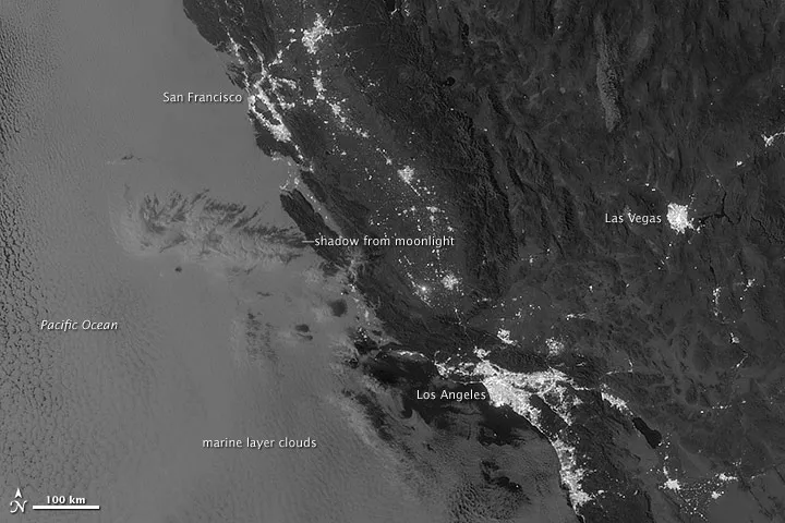
The nighttime viewing capabilities of the Suomi NPP satellite are giving earth scientists new views of the planet's surface once the sun goes down.
An image taken on Sept. 27, 2012, and released recently by NASA's Earth Observatory, shows off the satellite's penetrating gaze with a view of low-level, marine layer clouds off the coast of California. These clouds are invisible to technologies previously used to view nighttime scenes.
[Full Story: Night-Sensitive Satellite Spots Elusive Clouds]
Arctic invasion

If you live anywhere within the northern two-thirds of the United States, you've probably noticed that it's pretty chilly outside. The plunge in temperatures over the past few days comes courtesy of an invasion of Arctic air that has been captured in a mesmerizing new animation from the National Oceanic and Atmospheric Administration.
The animation, made with weather data from the NOAA/NCEP Real-Time Mesoscale Analysis, begins on Saturday (Jan. 19) with very cold air seen only over the Rockies, Montana, North Dakota, the northern half of Minnesota and the northern portions of New England. Much of the eastern and central parts of the country saw weekend weather that was balmier than usual for mid-January.
[Full Story: Chilling! Arctic Air Invasion Captured in Animation]
Look out below

A rockfall shattered a snowy landscape and barely missed a hut full of hikers in New Zealand Monday (Jan. 21).
The steep west face of Mount Dixon at Aoraki Mount Cook National Park fell at about 2:15 p.m. local time, leaving a dark trail of rock and ice across the park's Grand Plateau, the Timaru Herald reported.
[Full Story: Massive Rockfall Rattles New Zealand Park]
Get the world’s most fascinating discoveries delivered straight to your inbox.
Sneaky sharks

Cookiecutter sharks aren't very neighborly. Like most sharks (or any marine animal, for that matter), cookiecutters roam the ocean looking for food. But unlike typical meat eaters, these sharks don't kill their prey they just take a bite and move on.
And for the first time, scientists have found evidence that these small sharks even go after one of the world's most fearsome predators, the great white shark. Great whites are about 10 times the size of a cookiecutter shark.
[Full Story: Cookiecutter Shark Takes Bite Out of Great White]
Returning to greatness

Yaks are coming back. At least they are in a remote reserve on the Tibetan Plateau.
Researchers recently counted nearly 1,000 wild yaks in a rugged northern area of the plateau known as Hoh Xil, which is nearly the size of West Virginia and has very few human residents, according to the Wildlife Conservation Society, which helped conduct the census.
[Full Story: Huge Wild Yak Population Found in Tibetan Park]
Stronger glow

The orange glow atop Hawaii's Mount Kilauea was a little stronger yesterday (Jan. 15) than it has been in recent weeks. The volcano's lava lake lapped over the inner ledge of its vent, reaching a new high and bring molten rock closer than ever to the floor of Halema'uma'u crater.
The level was about 80 feet (25 meters) below the crater floor, the highest level reached since the summit vent blasted open in March 2008, the U.S. Geological Survey reports. The lava lake last surged on Oct. 23, 2012, when the high mark was measured at 100 feet (31 m) below the crater floor.
[Full Story: Hawaiian Lava Lake Hits New Record High]
Freaky night sky

The moon and stars may hog all the glory, but they're not the only light in the sky at night. The air itself glows from chemical reactions between oxygen and nitrogen and other molecules in the atmosphere.
The Suomi NPP satellite caught a massive thunderstorm making waves in the nightglow above Texas and Oklahoma on April 15, 2012. While nightglow is a well-known phenomenon, scientists were surprised at Suomi NPP's ability to detect it, according to NASA's Earth Observatory. During the satellite's check-out procedures, scientists thought this light source was a problem with the sensor until they realized that they were seeing the faintest light in the darkness of night, the Earth Observatory reported.
[Full Story: Amazing Image: Eerie Nightglow Over Texas]
