It's quick and easy to access Live Science Plus, simply enter your email below. We'll send you a confirmation and sign you up for our daily newsletter, keeping you up to date with the latest science news.
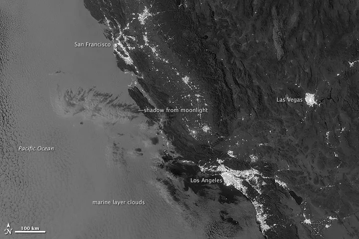
Marine layer clouds seen off the California coast at night by the Suomi NPP satellite, which can see certain nighttime features that were undetectable by previous satellite methods.
(Image credit: NASA Earth Observatory image by Jesse Allen and Robert Simmon, using VIIRS Day-Night Band data from the Suomi National Polar-orbiting Partnership)
The nighttime viewing capabilities of the Suomi NPP satellite are giving earth scientists new views of the planet's surface once the sun goes down.
An image taken on Sept. 27, 2012, and released recently by NASA's Earth Observatory, shows off the satellite's penetrating gaze with a view of low-level, marine layer clouds off the coast of California. These clouds are invisible to technologies previously used to view nighttime scenes.
Suomi NPP, run jointly by NASA and the National Oceanic and Atmospheric Administration, took the image with its Visible Infrared Imaging Radiometer Suite (VIIRS) "day-night band," which detects wavelengths of light from green to near-infrared. This means the satellite can spot gas flares, auroras, wildfires, city lights and reflected moonlight, according to the Earth Observatory. And add to that, low-lying clouds.
In the Suomi image, the marine layer clouds shroud the ocean along the California coast, from San Francisco to Los Angeles. You can also see the shadow of some higher-level clouds cast by moonlight onto the low clouds. Marine layer clouds are so called because they form in a sheet over the ocean as low stratus clouds. [Album: Reading the Clouds]
Here's how it works: Winds push moist surface-level air upward, causing it to expand and cool, while at the same time a coastal California feature called the Pacific High causes higher-level air to sink towards the surface, where it warms; these opposing forces create what is called an inversion layer between the surface and upper-air masses, according to the Scripps Institution of Oceanography.
While temperatures in the atmosphere typically get cooler the further up you go, the opposite happens in the inversion layer: Air is cooler toward the bottom, where the surface air is rising, and warmer toward the top of the layer, where the upper-level air is sinking.
If the air rising from the surface cools to a point at which the moisture in it condenses out below the inversion layer, marine layer clouds are formed, bounded on the top by the bottom of the inversion layer. This explains the typically uniform height of the cloud tops. The clouds are bounded on the bottom by the point at which they reach saturation and water condenses out.
Sign up for the Live Science daily newsletter now
Get the world’s most fascinating discoveries delivered straight to your inbox.
This image shows a layer of high clouds seen at night in the thermal infrared specturm of light. A lower level of marine layer clouds sitting below is invsible in this band of light because their temperature is too close to the ground to distinguish them.
(Image credit: NASA Earth Observatory image by Jesse Allen and Robert Simmon, using VIIRS Day-Night Band data from the Suomi National Polar-orbiting Partnership)
These clouds can pose a hazard to ship and air travel, according to the Earth Observatory, but detecting them has been tricky in the past because of the limits of other Earth-observing satellites. Another image of the same scene taken in thermal infrared wavelengths — the band of the light spectrum typically used by meteorologists to observe Earth's surface at night — illustrates this.
In this image, you can only see the higher-level clouds that were casting shadows in the previous image. The marine layer clouds are too close in temperature to the ground to show up as distinct feature in these wavelengths.
Suomi's capabilities therefore give meteorologists another tool to better observe and predict Earth's weather.
Reach Andrea Thompson atathompson@techmedianetwork.com and follow her on twitter @AndreaTOAP.Follow OurAmazingPlanet on Twitter@OAPlanet. We're also onFacebookand Google+.
Andrea Thompson is an associate editor at Scientific American, where she covers sustainability, energy and the environment. Prior to that, she was a senior writer covering climate science at Climate Central and a reporter and editor at Live Science, where she primarily covered Earth science and the environment. She holds a graduate degree in science health and environmental reporting from New York University, as well as a bachelor of science and and masters of science in atmospheric chemistry from the Georgia Institute of Technology.