It's quick and easy to access Live Science Plus, simply enter your email below. We'll send you a confirmation and sign you up for our daily newsletter, keeping you up to date with the latest science news.
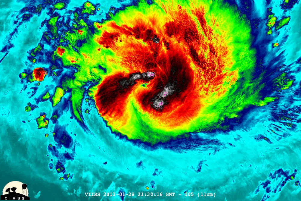
NASA-NOAA's Suomi NPP satellite captured this false-colored night-time image of Cyclone Felleng during the night on Jan. 28, 2013. Felleng is northwest of Madagascar. The image revealed some pretty cold overshooting tops and some interesting gravity waves propagating out from the storm in both the thermal and visible imagery.
Tropical Cyclone Felleng, currently spiraling off the east coast of the island of Madagascar, was caught in a NASA satellite image exhibiting "overshooting cloud tops," a clear sign that it is packing powerful storms.
A NASA statement describes an overshooting cloud top as a domelike protrusion that balloons out from the anvil head of thunderstorm cloud and shoots up into the stratosphere, the layer of the atmosphere above the troposphere. The troposphere is where most weather on Earth occurs.
The overshooting top is indicative of powerful storms because it takes a lot of energy to push through the tropopause, the boundary between the troposphere and stratosphere and where the temperature of the atmosphere goes from decreasing with height to increasing with height. Normally, the vertical growth of clouds stops at the tropopause, the NASA statement says, with the clouds then spreading out horizontally, forming the characteristic anvil shape of most strong thunderstorms.
The Suomi-NPP satellite, run jointly by NASA and the National Oceanic and Atmospheric Administration, captured a false-color thermal image of Felleng's powerful storms during the nighttime hours of Jan. 28 (local Madgascar time). The image shows the extremely cold clouds (the deep reds and pinks toward the center of the storm) that have shot up from the cyclone. (Cyclones are the same phenomenon as hurricanes and typhoons; they are just called different names in different ocean basins.)
The images showed that Felleng had strengthened considerably since the previous day, with bands of convective thunderstorms wrapping more tightly around the storm's center, the NASA statement said.
The Suomi imagery also showed gravity waves (an oscillating pattern in the atmosphere) emanating out from the storm.
On Jan. 29, 2013, NASA's Aqua satellite captured an image of Cyclone Felleng at 5:14 a.m. EST that showed strong thunderstorms around the center of circulation and a 22 nautical mile-wide eye obscured by high clouds. The western edge of the storm wass approaching Madagascar (left).
(Image credit: NASA Goddard MODIS Rapid Response Team)
NASA's Aqua satellite also took a look at the cyclone and produced an image in the visible light spectrum. This image also showed the strength of Felleng's storms and that its western edge was approaching Madagascar.
Sign up for the Live Science daily newsletter now
Get the world’s most fascinating discoveries delivered straight to your inbox.
Felleng currently has maximum sustained winds of 132 mph (213 kph), with gusts up to 161 mph (259 kph), according to the Joint Typhoon Warning Center, run by the U.S. Navy and Air Force. The storm will be taking a turn to the south, running parallel to the Madagascar coast in the coming days, JTWC predictions show, running between it and the island of La Reunion.
Andrea Thompson is an associate editor at Scientific American, where she covers sustainability, energy and the environment. Prior to that, she was a senior writer covering climate science at Climate Central and a reporter and editor at Live Science, where she primarily covered Earth science and the environment. She holds a graduate degree in science health and environmental reporting from New York University, as well as a bachelor of science and and masters of science in atmospheric chemistry from the Georgia Institute of Technology.

 Live Science Plus