Twin tornadoes tear perfectly parallel tracks through Mississippi during deadly 'superstorm' — Earth from space
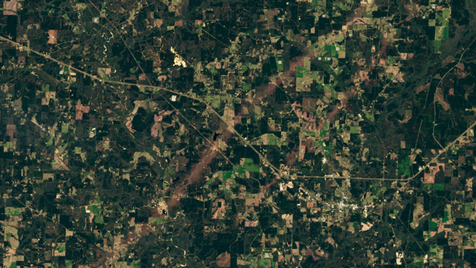
A satellite photo from March shows a pair of parallel tornado tracks in Mississippi, leftover from a deadly storm system that spawned over 100 twisters in more than a dozen U.S. states.


QUICK FACTS
Where is it? Tylertown, Mississippi [31.140899624, -90.17186140]
What's in the photo? A pair of parallel tracks carved out by tornadoes during a major storm
Which satellite took the photo? Landsat 8
When was it taken? March 22, 2025
This striking satellite image shows two near-perfectly parallel tornado tracks in Mississippi that were carved into the ground after a deadly storm system triggered more than 100 twisters across the U.S. in early 2025.
Between March 14 and 16, a series of extreme thunderstorms broke out in the High Plains and Midwest thanks to an "expansive upper-level trough" of warm, moist air. This storm system triggered 113 tornadoes across 14 U.S. states, according to The Weather Channel. At least 42 people are believed to have been killed, according to NBC News.
One of the worst-hit states was Mississippi, which experienced 18 tornadoes. Half of these reached at least Level 2 ("considerable damage") on the Enhanced Fujita scale (EF Scale), which measures the damage caused by a tornado. Around 1,000 houses were damaged in the state, according to the Mississippi Emergency Management Agency. Dozens of businesses and farms were also hit.
In this satellite image, you can see two different tracks that were carved out by two separate tornadoes just outside of Tylertown, Mississippi. The longer and wider track stretches up to 55 miles (89 kilometers), while the smaller track is only around 9 miles (15 km) long. It is unclear which one appeared first, or how much time passed between the respective twisters.
Related: See all the best images of Earth from space

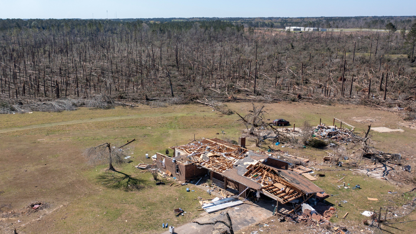
The larger of the two tornadoes from the satellite photo ranked as Level 4 ("devastating damage") on the Enhanced Fujita scale. This farm, just outside of Tylertown, was one of its victims.
The larger of the two tornadoes is believed to have reached Level 4 ("devastating damage") on the EF Scale, making it the single most powerful twister of the entire storm system, according to NASA's Earth Observatory. Its wind speed likely reached 170 mph (274 km/h), which is equivalent to a Category 5 hurricane.
Around 50 miles (80 km) northeast of Tylertown, aerial photographs revealed another pair of tornadoes had passed at right angles to one another, creating a large X-shape in a forested area of Covington County, according to the National Weather Service station at Jackson, Mississippi.
Get the world’s most fascinating discoveries delivered straight to your inbox.
2025 has been one of the worst years for U.S. tornadoes in recent memory, partly due to the recent La Niña phenomenon, which altered the trajectory of the Pacific jet stream above North America, creating drier and warmer conditions in southern states, according to the National Oceananic and Atmospheric Administration (NOAA).
March was particularly extreme, with a record 299 twisters recorded during that month, according to the National Centers for Environmental Information. (For context, the entire U.S. normally only experiences around 80 twisters during March, on average.)
One location in western Covington County just north of Spring Hill School Road was struck twice by tornadoes just 41 minutes apart this past Saturday afternoon.The first tornado was more narrow as it approached the end of its path. The next storm that followed was wider. pic.twitter.com/mzzaJZAzRwMarch 21, 2025
But even without La Niña, the frequency of tornadoes has been increasing over time due to rising sea surface temperatures off the Gulf coast — a direct result of human-caused climate change.
Like other types of extreme weather, such as wildfires, heatwaves and floods, climate change is also making tornadoes more powerful, costly and deadly. In 2023, for example, at least 26 people were killed by a single, nearly mile-wide "wedge tornado" that ripped through parts of Mississippi.
MORE EARTH FROM SPACE
Additionally, tornadoes are now starting to impact places where they have not historically been seen before. Some researchers have previously suggested that "Tornado Alley" — the central region of the U.S. where tornadoes are traditionally most likely to occur, in states such as Texas, Oklahoma, Kansas, Iowa and Nebraska — could now be considered to be everything east of the Rockies.
Researchers at NASA's Langley Research Center are currently working on a way to better predict when tornadoes will form by analyzing cloud patterns in satellite photos. They hope that this could eventually warn people about an impending twister up to 10 minutes before it happens, potentially saving many lives, according to the Earth Observatory.

Harry is a U.K.-based senior staff writer at Live Science. He studied marine biology at the University of Exeter before training to become a journalist. He covers a wide range of topics including space exploration, planetary science, space weather, climate change, animal behavior and paleontology. His recent work on the solar maximum won "best space submission" at the 2024 Aerospace Media Awards and was shortlisted in the "top scoop" category at the NCTJ Awards for Excellence in 2023. He also writes Live Science's weekly Earth from space series.
You must confirm your public display name before commenting
Please logout and then login again, you will then be prompted to enter your display name.

 Live Science Plus


