
 Live Science Plus


Tikal: The iconic ancient Maya city in Guatemala
Dozens of Maya elite are buried within Tikal's temples.

The ancient Maya city of Tikal, in modern-day Guatemala, flourished between roughly 600 B.C. and A.D. 900. Starting out as a modest series of hamlets, it became a great Maya city-state with more than two dozen major pyramids.
The name "Tikal" is a modern-day Maya name that means "at the waterhole." In ancient times, it was known as Mutul and was at the center of a powerful Maya kingdom, archaeologist Robert Sharer, who was a curator at the Penn Museum, wrote in his book "The Ancient Maya, sixth edition" (Stanford University Press, 2005). Tikal is one of the largest archaeological sites in Central America and is encompassed by Tikal National Park.
At its peak from A.D. 682 to 909 the city spread over at least 50 square miles (130 square kilometers) wrote John Montgomery, a researcher who studied and wrote about the Maya extensively, wrote in his book "Tikal: An Illustrated History of the ancient Mayan Capital" (Hippocrene Books, 2001). Population estimates vary, but it's likely that somewhere between 45,000 and 62,000 people lived in the the city at the height of its power, wrote David Webster, professor emeritus of anthropology at Penn State University, in his book "The Population of Tikal: Implications for Maya Demography" (Archaeopress, 2018). This made it one of the largest cities in the region.

To maintain such a large population, the city's inhabitants created a sophisticated water management system that ensured people had access to water during periods of low rainfall, a study published in 2012 in the Proceedings of the National Academy of Sciences showed. It included a system of dams and reservoirs as well as a sand filtration system that was used to clear water. It was in use for about 1000 years, until the city's 10th century collapse.
Like people in other Maya cities, Tikal's residents used a system of glyptic writing inscribed both on stone and on a perishable material made from the bark of trees (most of which have not survived). Scholars have been able to decipher the writing, which, along with the city's archaeological remains, have helped them to reconstruct much of Tikal's past.
Tikal's Origins
Tikal is in an area of Central America that has numerous other Maya remains. In 2018 researchers detected over 60,000 previously unknown Maya structures in Guatemala, including pyramids, houses and defensive fortifications. They used lidar (short for "light detection and ranging"), which works by beaming laser pulses to the ground from aircraft. When the pulses bounce back, their wavelengths are measured to create a virtual, three-dimensional image of the archaeological remains on the ground.
Stone cut buildings were first constructed at Tikal around 200 B.C. notes Montgomery while the "Lost World" Complex, one of the first monumental sites at Tikal, was finished around A.D. 1. The earliest inhabitants at Tikal were Maya although they were likely influenced by people from a city called Teotihuacan. The earliest inhabitants at Tikal likely spoke Mayan languages, noted Montgomery.
Get the world’s most fascinating discoveries delivered straight to your inbox.
Teotihuacan influence

Lidar data over a map of the Maya city of Tikal reveals an unexcavated structure, the hook-shaped object below the Mundo Perdido, that bears an eerie resemblance to a pyramid hundreds of miles away.
Teotihuacan was a city in central Mexico more than 600 miles (1,000 km) away that flourished between roughly 100 B.C.- A.D. 600. Their influence has been identified in some of the architecture and artifacts found at Tikal and they exercised political influence and possibly even control over the city. Maya writing, including inscriptions found at Tikal, refers to the city using a glyph that translates as "cattail reed," and artistic motifs from Teotihuacan, such as depictions of the rain god Tlaloc, also appear at Tikal.
One notable example of Teotihuacan's influence occurred on Sept. 13, 379, when a ruler named Siyaj K'ak' is recorded to have ascended at Tikal. He is depicted in carvings wearing feathers and shells and holding an atlatl (spear-thrower) — features that are typically associated with Teotihuacan, wrote Montgomery. This may signify that he was from Teotihuacan or strongly influenced or supported by them when he became king.
Another notable example of Teotihuacan's influence on the Maya city is a pyramid and courtyard at Tikal that appears to be a miniature version of a pyramid complex at Teotihuacan now known as La Ciudadela or "The Citadel." Researchers at Tikal announced the discovery of the miniature version in 2021, and dated it to around A.D. 250 — a time when Teotihuacan was flourishing. The miniature version has the same layout and orientation as The Citadel and has artifacts linked to Teotihuacan, such as ceramics and dart points, and a grave.
Twin pyramid complexes
Tikal is famous for its numerous pyramids. The ambitious pyramid construction projects were driven in part by the famous Maya calendar. Starting at least as early as A.D. 672, the city's rulers constructed a twin pyramid complex at the end of every K'atun (20-year period). Each of these pyramids was flat-topped, built adjacent to its twin, and contained a staircase on each side. Between the pyramids was a plaza that had structures laid out to the north and south.
One early example was built by the ruler Jasaw Kaan K'awil around A.D. 700. "On the south side is a building with nine doorways; on the north, a walled enclosure containing a stela [an inscribed stone] and altar," Sharer wrote in his book. So far, archaeologists have found nine of these twin pyramid complexes at Tikal; construction of them appears to have continued until close to the city's end.
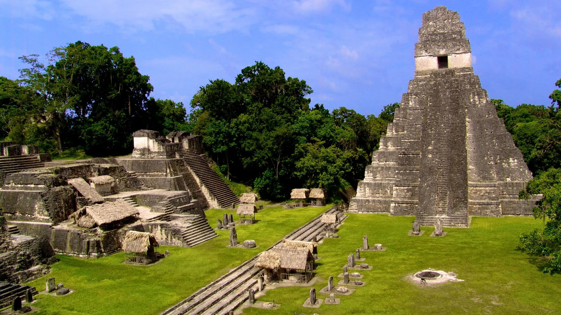
Temples I & II
In addition to the twin pyramid complexes, Tikal's rulers also built "temple" pyramids — structures that often marked the burial place of a ruler. Two of them, known today as Temples I and II, face each other at the center of the city, with Tikal's grand plaza sitting between them.

Temple of the Great Jaguar or Temple I in Tikal. This pyramid has an altitude of 145 feet (44 meters). It is known as the Great Jaguar because of the jaguar carved in the lintel of its main door.
Temple I, also known as the Temple of the Great Jaguar, was built around 730. It rises 145 feet (44 meters) off the ground, or about the height of a 13-story building. A stairway goes up over a series of nine step layers and leads to an enclosed room at the top that has images of the ruler it was built for — Jasaw Kaan K'awil. He was a king who led Tikal's forces to victory against the city's most bitter enemy — the rival Maya city of Calakmul, located in what is now southern Mexico. In 1959, archaeologists discovered Jasaw Kaan K'awil's burial chamber inside the pyramid's interior, which contained many luxury goods, including jaguar pelts, jade and "delicately incised images of figures in canoes on human bones," wrote Heather McKillop, an alumni professor in the Department of Geography and Anthropology at Louisiana State University, in her book "The Ancient Maya: New Perspectives" (ABC-CLIO, 2004).

Temple II or the Temple of the Masks is in the Great Square inside the archeological site of Tikal, Guatemala.
The pyramid facing Jasaw Kaan K'awil's, known today as Temple II or the Temple of the Masks, is believed to be dedicated to the ruler's wife, Lady Tun Kaywak. Researchers think she was from the city of Yaxhá about 19 miles (30 km) southeast of Tikal. Her marriage to K'awil cemented a political alliance between the two cities. Her pyramid rises up 125 feet (38 m) and contains three step layers. At a doorway on the top, an image of a woman, believed to be Tun Kaywak, is carved on wood. "Lady Tun Kaywak wears embroidered stoles [a long shawl] and an elaborate Sun God bonnet, her image now badly eroded and worm-eaten," Montgomery wrote.
North Acropolis

North Acropolis of Tikal / Yax Mutal, ancient Maya city near the town Flores, Guatemala.
Just to the north of these two temples is an area now known as the North Acropolis. It contains pyramid-shaped temples and royal tombs, and was used as a burial place for the early rulers of Tikal. Montgomery wrote that the "tomb and shrines [are] equivalent to Tikal's 'Valley of the Kings.'"
The North Acropolis appears to have been started sometime between 350 B.C. and 200 B.C. and was rebuilt several times throughout the city's history, wrote Herbert Stanley Loten, a professor of architecture at Carleton University in Ottawa, in a study published in the book "Tikal: Dynasties, Foreigners & Affairs of State" (School of American Research Press, 2003). The acropolis covers more than 2.5 acres (1 hectare).
Palace

The Central Acropolis is a palace complex on the south side of the Great Plaza. Tikal National Park, Guatemala, is an archeological site of the pre-Columbian Maya civilization and since 1979, has been a UNESCO World Heritage Site.
The city's palace, also known as the Central Acropolis, lies to the south of Temples I and II. Like the North Acropolis, it was expanded on and modified over time.
It was in use at least as early as the reign of Chak Tok Ich'aak I, who ruled for around two decades around A.D. 375. His palace was a relatively modest structure that contained stairways on the east and west and stone benches.
As time went on, the palace expanded into a complex with half a dozen courtyards and a water reservoir to the south. At the southern end of the complex is a five-story palace that "imparted a terraced, pyramidal effect," Montgomery wrote.
On the east side of the complex is a "reviewing stand" that overlooks an I-shaped ball court that has been excavated. The ball game, which was popular across parts of the Western Hemisphere at the time, was played with a rubber ball, although the exact rules of the game are unknown.
Lost World complex
One of the earliest pyramids at Tikal was constructed around A.D. 1 and is known as Mundo Perdido (Spanish for the "Lost World"). It stands about 100 feet (30 m) high, and at the time "represented one of the most massive structures anywhere in Precolumbian America," Montgomery wrote.
The complex was "among the earliest of the Maya's astronomical compounds, the pyramid-shrine orientation allowed for the calculation of the equinox and solstice," Montgomery wrote. Several wealthy burials have been found at this complex and may be those of royalty.
Tikal's end
Tikal and much of the Maya world collapsed around A.D. 900, although some cities, such as Chichen Itza about 250 miles (400 km) north of Tikal, continued to flourish for centuries. The reason for the collapse is still debated. Drought, aggravated by deforestation, appears to have played a significant role, a team of researchers reported in a study published in 2012 in the journal Geophysical Research Letters.
Pollution may also have played an important role in the city's collapse. Two of Tikal's largest water reservoirs had become heavily polluted with high levels of mercury and phosphate, scientists found in a study published in 2020 in the journal Scientific Reports.
The jungle reclaimed the city after it was abandoned, covering its many pyramids with vegetation. However not all Maya cities became abandoned. In the Yucatan the city of Chichen Itza actually grew, becoming one of the largest Maya cities after the collapse of Tikal.
But while Tikal and other cities collapsed, the Maya people live on, with over 7 million Maya living in Central America and other parts of the world today, the Smithsonian Institute notes.
Additional resources
- Tikal is now a UNESCO World Heritage Site and its listing can be found on the UNESCO website.
- The Penn Museum conducted excavations at Tikal between 1956 and 1970 and images of their work can be accessed at the Tikal Project Image Database.
- The Maya people live on today, and the website of the Mayan League contains more information on the modern Maya people and the challenges that they face.
Originally published on Live Science on Sept. 26, 2012 and updated on Aug. 5, 2022.

Owen Jarus is a regular contributor to Live Science who writes about archaeology and humans' past. He has also written for The Independent (UK), The Canadian Press (CP) and The Associated Press (AP), among others. Owen has a bachelor of arts degree from the University of Toronto and a journalism degree from Ryerson University.