It's quick and easy to access Live Science Plus, simply enter your email below. We'll send you a confirmation and sign you up for our daily newsletter, keeping you up to date with the latest science news.
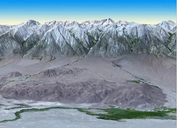
At 14,505 feet (4,421 meters) in elevation, California's Mt. Whitney, located in the Sierra Nevada Mountains on the west side of Owens Valley, is the highest point in the contiguous United States. Image credit: NASA/GSFC/METI/ERSDAC/JAROS, and U.S./Japan ASTER Science Team
The most complete digital topographic ever made of the Earth was released by NASA today (Oct. 17).
The map , known as a global digital elevation model, was created from images collected by the Japanese Advanced Spaceborne Thermal Emission and Reflection Radiometer, or ASTER, instrument aboard NASA's Terra satellite.
The 3-D effect is achieved by merging two slightly offset two-dimensional images (called stereo-pair images) to create depth.
The first version of the map was released by NASA and Japan's Ministry of Economy, Trade and Industry (METI) in June 2009.
"The ASTER global digital elevation model was already the most complete, consistent global topographic map in the world," said Woody Turner, ASTER program scientist at NASA Headquarters in Washington, D.C. "With these enhancements, its resolution is in many respects comparable to the U.S. data from NASA's Shuttle Radar Topography Mission, while covering more of the globe."
The Advanced Thermal Emission and Reflection Radiometer (ASTER) instrument on NASA's Terra spacecraft provided this spacebird's-eye view of the eastern part of Grand Canyon National Park in northern Arizona in this image, acquired July 14, 2011. Image credit: NASA/GSFC/METI/ERSDAC/JAROS, and U.S./Japan ASTER Science Team
The ASTER data cover 99 percent of Earth's landmass and span from 83 degrees north latitude to 83 degrees south.
The improved version of the map adds 260,000 additional stereo-pair images to improve coverage. It features improved spatial resolution, increased horizontal and vertical accuracy, more realistic coverage over water bodies and the ability to identify lakes as small as 0.6 miles (1 kilometer) in diameter. The map is available online to users everywhere at no cost.
Sign up for the Live Science daily newsletter now
Get the world’s most fascinating discoveries delivered straight to your inbox.
"These data can be used for a broad range of applications, from planning highways and protecting lands with cultural or environmental significance, to searching for natural resources," said Mike Abrams, ASTER science team leader at NASA's Jet Propulsion Laboratory in Pasadena, Calif.
For the science geek in everyone, Live Science offers a fascinating window into the natural and technological world, delivering comprehensive and compelling news and analysis on everything from dinosaur discoveries, archaeological finds and amazing animals to health, innovation and wearable technology. We aim to empower and inspire our readers with the tools needed to understand the world and appreciate its everyday awe.

 Live Science Plus