It's quick and easy to access Live Science Plus, simply enter your email below. We'll send you a confirmation and sign you up for our daily newsletter, keeping you up to date with the latest science news.
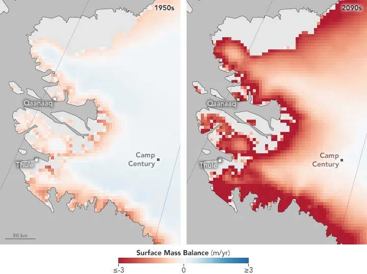
These maps show the surface mass balance of ice, or the net change between the accumulation and ablation of ice and snow on a glacier's surface. Ablation happens when ice thins due to evaporation, melting and wind. The dark red indicates areas where the ice surface is likely to drop by 10 feet (3 meters) or more per year.
Melting glaciers have revealed a number of surprises over the past few years, from Viking artifacts in Norway to World War I burials in the Italian Alps. And one day, if global warming continues its current course, Greenland's retreating ice sheet could expose a more troubling relic of the past: a Cold War military base and whatever biological, chemical and radioactive waste is left inside, scientists say.
NASA's Earth Observatory posted maps today (Jan. 31) that show the changes expected to take place near the site of Camp Century, a once-secret U.S. military base built in 1959 primarily to test the possibility of launching nuclear missiles from the Arctic to the Soviet Union.
The site was abandoned in 1967 and is now buried about 100 feet (30 meters) beneath a crust of snow and ice. But the maps, analyzed as part of a study published in August 2016 in the journal Geophysical Research Letters, show that because of ice loss, Camp Century could become an environmental hazard by the end of this century. [Photos: Top-Secret, Cold War-Era Military Base in Greenland]
"When we looked at the climate simulations, they suggested that rather than perpetual snowfall, it seems that as early as 2090, the site could transition from net snowfall to net melt," William Colgan, the study's lead author and an assistant professor in Earth sciences at York University in Toronto, said in a statement last year. "Once the site transitions from net snowfall to net melt, it's only a matter of time before the wastes melt out; it becomes irreversible."
Radar data collected from NASA's airborne instruments revealed disturbances indicative of buried waste in the Greenland Ice Sheet at Camp Century.
(Image credit: NASA Operation IceBridge)
The color-coded map reveals places where the ice surface is projected to drop 10 feet (3 m) or more per year (dark red), areas where no change is expected in this so-called surface mass balance (white) and areas expected to see slight gains in ice cover (light blue).
Colgan and his colleagues took an inventory of the waste left in Camp Century and found that the site contains about 53,000 gallons (200,000 liters) of diesel fuel, 6.3 million gallons (24 million liters) of wastewater, including sewage, as well as unknown volumes of low-level radioactive coolant and polychlorinated biphenyls (PCBs). These pollutants threaten to seep into marine ecosystems as the ice melts, the researchers said.
Eventually, the cleanup of Camp Century could lead to one of the first climate-change-related political disputes, as international law is apparently ambitious about the responsibility for already-discarded hazardous waste, the researchers noted.
Sign up for the Live Science daily newsletter now
Get the world’s most fascinating discoveries delivered straight to your inbox.
Colgan told the Earth Observatory that this example "is just one in a very long list of reasons to say, 'How do we try [to] mitigate climate change now?'"
Megan has been writing for Live Science and Space.com since 2012. Her interests range from archaeology to space exploration, and she has a bachelor's degree in English and art history from New York University. Megan spent two years as a reporter on the national desk at NewsCore. She has watched dinosaur auctions, witnessed rocket launches, licked ancient pottery sherds in Cyprus and flown in zero gravity. Follow her on Twitter and Google+.