
 Live Science Plus


In Photos: Mysterious Radar Blob Puzzles Meteorologists
What's that?!

On June 4, 2013, meteorologists in Huntsville, Ala., noticed a "blob" on their radar screen that looked like a strong thunderstorm, despite the fact the sun was shining and not a drop of rain could be found within a few hundred miles. After some sleuthing, and several wacky explanations, the scientists identified the culprit as man-made: a military test.
The Blob

When the team looked at the blob using standard weather radar, all indications were it was a strong thunderstorm. Then they turned to so-called dual-polarity technology developed in the last few years by the National Weather Service. This advanced radar allows scientists to scan in both the horizontal and vertical directions. Shown here, the dual-pol radar: Green is usually light precipitation, yellow is moderate rain, and red is heavy precipitation, or it could be hail or even a tornado in extreme cases.
Spreading Blob
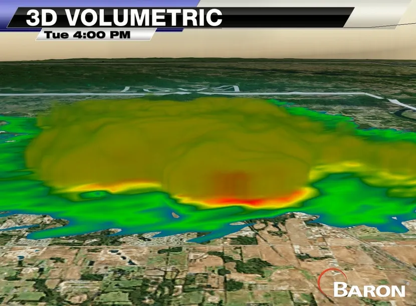
An image of a mysterious blob seen in weather radar on June 4, 2013, in Huntsville, Ala.

Time Sequence

"The blob quickly grew in the first few hours after it started … and then stayed about that size through the evening before dissipating," said Matthew Havin, data services manager at Baron Services.
Clear Skies

The weird blob on the weather radar stumped meteorologists partly because the skies for a few hundred miles were relatively clear in Huntsville, Ala.
Scattered Energy

Here's a look at weather radar using NEXRAD (Next Generation Radar), a technology in which the radar emits a burst of energy into the atmosphere. If that energy strikes an object, such as a raindrop, the energy gets scattered in all directions (blue), with a small fraction of that scattered energy directed back to the radar. The colors indicate the intensities of that energy reflected back at the radar, with blues and greens indicating low intensity and reds and purples indicating high intensities.
Dissipating Blob

Another look at the blob using NEXRAD at 11 p.m. that day.
Get the world’s most fascinating discoveries delivered straight to your inbox.
Jeanna Bryner is managing editor of Scientific American. Previously she was editor in chief of Live Science and, prior to that, an editor at Scholastic's Science World magazine. Bryner has an English degree from Salisbury University, a master's degree in biogeochemistry and environmental sciences from the University of Maryland and a graduate science journalism degree from New York University. She has worked as a biologist in Florida, where she monitored wetlands and did field surveys for endangered species, including the gorgeous Florida Scrub Jay. She also received an ocean sciences journalism fellowship from the Woods Hole Oceanographic Institution. She is a firm believer that science is for everyone and that just about everything can be viewed through the lens of science.