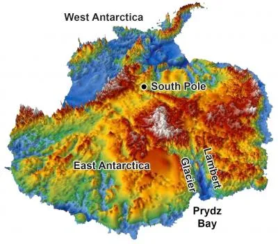
This 3-D reconstruction of the topography hidden under Antarctica's two-mile-thick coating of ice was made using data from radar surveys. The continent was relatively flat before glaciers started carving deep valleys 34 million years ago, a new study finds.
(Image credit: Stuart N. Thomson/UA department of geosciences)
Like Alaska's mighty Yukon, a broad river once flowed across Antarctica, following a gentle valley shaped by tectonic forces at a time before the continent became encased in ice. Understanding what happened when rivers of ice later filled the valley could solve certain climate and geologic puzzles about the southernmost continent.
The valley is Lambert Graben in East Antarctica, now home to the world's largest glacier. Trapped beneath the ice, the graben (which is German for ditch or trench) is a stunning, deep gorge. But before Antarctica's deep freeze 34 million years ago, the valley was relatively flat and filled by a lazy river, leaving a riddle for geologists to decode: How did Lambert Graben get so steep, and when was it carved?
The key to Lambert Graben's history was found in layers of sediments just offshore, in Prydz Bay. In a new study, Stuart Thomson, a geologist at the University of Arizona (UA) in Tucson, looked into the past by decoding sands deposited by the river, and the messy piles left behind by the glacier. The river sands are topped with a thick layer of coarser sediment that signals the onset of glacial erosion in the valley, the researchers found. The erosion rate more than doubled when the glaciers moved in, Thomson said.
"There's a big effort to model how glaciers flow in Antarctica, and these models need a landscape over which glaciers can flow," Thomson told OurAmazingPlanet. "Once these models can predict past changes, they can more accurately predict what will happen with future climate changes."
The sediments also hold clues to the tectonic evolution of East Antarctica, and a mountain range buried beneath the vast, thick ice sheet. [Album: Stunning Photos of Antarctic Ice]
Sign up for the Live Science daily newsletter now
Get the world’s most fascinating discoveries delivered straight to your inbox.
The findings are detailed in the March 2013 issue of the journal Nature Geoscience.
History of the ice
Lambert Graben formed during the breakup of Gondwana, an ancient supercontinent, a process that happened in stages. Antarctica, India and Africa tore apart in the Late Cretaceous (about 80 million years ago). The split created long, linear valleys oriented perpendicular to the continental coastlines. At the time, Earth's climate was warmer than it is today, and as Antarctica moved southward, settling into its home over the South Pole, the continent teemed with plants and animals.
Antarctica and the Gondwana supercontinent, 150 million years ago.
(Image credit: WHOI)
Scientists can partially reconstruct this past environment with fossils and through radar that peers beneath the ice to map the shapes of the rock below. A 3D map of Antarctica today shows chasms carved by glaciers, rugged mountains and other remnants of its warmer existence.
But the surveys tell nothing about how the landscape looked before the ice carved out all those features. "People have speculated when the big fjords formed under the ice," Thomson said. "But no one knows for sure until you sample the rocks or the sediments."
Thomson and his colleagues analyzed sediments drilled from the ocean floor just offshore of Lambert Glacier, as well as from onshore moraines, the rock piles pushed up by glaciers. Tests on minerals in the sands and muds helped them figure out when and how fast the surface eroded.
Here's what the sediments say: From about 250 million to 34 million years ago, the region around Lambert Glacier was relatively flat, and drained by slow-moving rivers, Thomson said. About 34 million years ago, which coincides with a cooling of Earth's climate, big glaciers appeared, shaping the spectacular valley now hidden under thick ice.
"It seemed like it occurred very early on, 34 [million] to 24 million years ago," Thomson said. Erosion slowed dramatically as the ice sheet stabilized about 15 million years ago, he said.
Some 5,250 to 8,200 feet (1.6 to 2.5 kilometers) of rock have since disappeared, ground down by glaciers and carried away by the ice, according to the study.
"Glaciers can carve deep valleys quickly — and did so on Antarctica before it got so cold that the most of it got covered by 1 or 2 miles [1.6 to 3.2 km] of thick, stationary ice," Peter Reiners, a UA geologist and study co-author, said in a statement.
Clues to buried mountain range
Lambert Graben extends about 375 miles (600 km) inland, ending at one of Antarctica's most enigmatic features — an entombed mountain range called the Gamburtsev Mountains. Buried under the ice, the mountains rose during Gondwana's rifting. Geologic evidence suggests two pulses of upliftfrom rifting events about 250 million years ago and 100 million years ago pushed up the jagged peaks.
But Thomson and his colleagues did not find evidence in the sediments for a second uplift phase 100 million years ago. The river sands contain minerals from the Gamburtsev Mountains, and the tiny grains suggest the mountains got their height with one tectonic push.
"This underscores both the mountain range's remarkable age and the extraordinary degree of subglacial landscape preservation," writes Darrel Swift in an accompanying article in Nature Geoscience. Swift, a geologist at the University of Sheffield in the United Kingdom, was not involved in the study.
Becky Oskin covers Earth science, climate change and space, as well as general science topics. Becky was a science reporter at Live Science and The Pasadena Star-News; she has freelanced for New Scientist and the American Institute of Physics. She earned a master's degree in geology from Caltech, a bachelor's degree from Washington State University, and a graduate certificate in science writing from the University of California, Santa Cruz.