 Live Science Plus


'Sunglint' Silhouettes Northeast Coast in Astronaut Photo
You are now subscribed
Your newsletter sign-up was successful
Want to add more newsletters?

Delivered Daily
Daily Newsletter
Sign up for the latest discoveries, groundbreaking research and fascinating breakthroughs that impact you and the wider world direct to your inbox.

Once a week
Life's Little Mysteries
Feed your curiosity with an exclusive mystery every week, solved with science and delivered direct to your inbox before it's seen anywhere else.

Once a week
How It Works
Sign up to our free science & technology newsletter for your weekly fix of fascinating articles, quick quizzes, amazing images, and more

Delivered daily
Space.com Newsletter
Breaking space news, the latest updates on rocket launches, skywatching events and more!

Once a month
Watch This Space
Sign up to our monthly entertainment newsletter to keep up with all our coverage of the latest sci-fi and space movies, tv shows, games and books.

Once a week
Night Sky This Week
Discover this week's must-see night sky events, moon phases, and stunning astrophotos. Sign up for our skywatching newsletter and explore the universe with us!
Join the club
Get full access to premium articles, exclusive features and a growing list of member rewards.
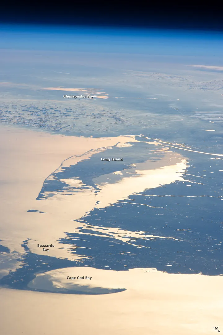
The coast of the northeast United States is silhouetted against the shimmering water of Cape Cod Bay and Long Island Sound in a new photo captured by astronauts on the International Space Station.
The phenomenon of light from a setting sun reflecting off water to create a shining, mirrorlike surface is called sunglint, and is evident throughout the photo.
The photo was taken on Feb. 14 at 4:26 p.m. EST by the space station's Expedition 34 crew, which includes commander Kevin Ford of NASA, as well as U.S. astronaut Tom Marshburn, Canadian astronaut Chris Hadfield, and Russian cosmonauts Oleg Novitskiy, Evgeny Tarelkin and Roman Romanenko.
At that time of day, the sun was low on the horizon, as evidenced by the wide extent of the sunglint effect, which reaches all the way from Long Island Sound to the waters of Chesapeake Bay, more than 250 miles (400 kilometers) away. From the vantage of the International Space Station, 260 miles (420 km) above Earth, much of the region is visible, as well as the limb of the planet and its thin atmosphere fading away into the blackness of space.
On the photo's right side, the waters off the Massachusetts coast and in Long Island Sound are especially bright where the peak reflection point is, according to the Earth Observatory.
The photo shows the northeast United States just days after a powerful blizzard blanketed many areas in heavy snow on Feb. 9.
"There is little in this image to indicate that the region was still recovering from a major winter storm that dropped almost one meter (three feet) of snow over much of the northeastern USA less than a week earlier," the Earth Observatory wrote.
Follow OurAmazingPlanet for the latest in Earth science and exploration news on Twitter @OAPlanet. We're also on Facebook & Google+.

