It's quick and easy to access Live Science Plus, simply enter your email below. We'll send you a confirmation and sign you up for our daily newsletter, keeping you up to date with the latest science news.
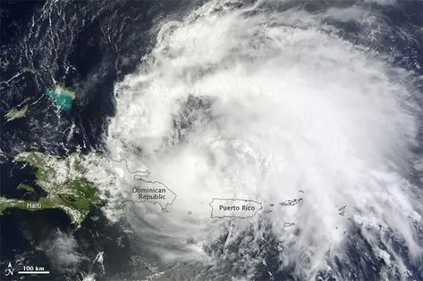
After a brief dip in its power, Hurricane Irene has re-strengthened and has now reached Category 3 status, making it the first major hurricane of the 2011 Atlantic season.
Irene is now barreling through the Bahamas with winds of 115 mph (185 kph) and could strengthen further. Category 3 hurricanes on the Saffir-Simpson scale of hurricane strength have winds between 111 to 130 mph (178 to 209 kph).
Irene's predicted path will take it up through the Bahamas, then up to the Outer Banks of North Carolina and along the coast of the Mid-Atlantic and Northeast states where it could finally make landfall. The storm would like weaken some in the cooler waters off the northern states, though it could still bring torrential rains and strong storm surge. [Related: Could New York City Handle a Hurricane?]
The predicted path that Hurricane irene will taken in the next five days. The dots with
Rainfall in the Bahamas is expected to total between 6 to 12 inches (15 to 30.5 centimeters), with some isolated pockets of 15 inches (38 cm). Storm surge in the islands is expected to be as much as 7 to 11 feet (2 to 3.4 meters) above normal tide levels.
Irene is the first hurricane and first major hurricane for what has been forecast to be an active season. The National Oceanic and Atmospheric Administration (NOAA) updated its forecast on Aug. 4, predicting 14 to 19 named storms (which include tropical storms and hurricanes), seven to 10 hurricanes and three to five major hurricanes. An average Atlantic hurricane season will see 11 named storms, six hurricanes and two major hurricanes. August through October are the peak months of the Atlantic hurricane season.
For the science geek in everyone, Live Science offers a fascinating window into the natural and technological world, delivering comprehensive and compelling news and analysis on everything from dinosaur discoveries, archaeological finds and amazing animals to health, innovation and wearable technology. We aim to empower and inspire our readers with the tools needed to understand the world and appreciate its everyday awe.

 Live Science Plus