A History of Destruction: 8 Great Hurricanes
Get the world’s most fascinating discoveries delivered straight to your inbox.
You are now subscribed
Your newsletter sign-up was successful
Want to add more newsletters?

Delivered Daily
Daily Newsletter
Sign up for the latest discoveries, groundbreaking research and fascinating breakthroughs that impact you and the wider world direct to your inbox.

Once a week
Life's Little Mysteries
Feed your curiosity with an exclusive mystery every week, solved with science and delivered direct to your inbox before it's seen anywhere else.

Once a week
How It Works
Sign up to our free science & technology newsletter for your weekly fix of fascinating articles, quick quizzes, amazing images, and more

Delivered daily
Space.com Newsletter
Breaking space news, the latest updates on rocket launches, skywatching events and more!

Once a month
Watch This Space
Sign up to our monthly entertainment newsletter to keep up with all our coverage of the latest sci-fi and space movies, tv shows, games and books.

Once a week
Night Sky This Week
Discover this week's must-see night sky events, moon phases, and stunning astrophotos. Sign up for our skywatching newsletter and explore the universe with us!
Join the club
Get full access to premium articles, exclusive features and a growing list of member rewards.
Notorious storms
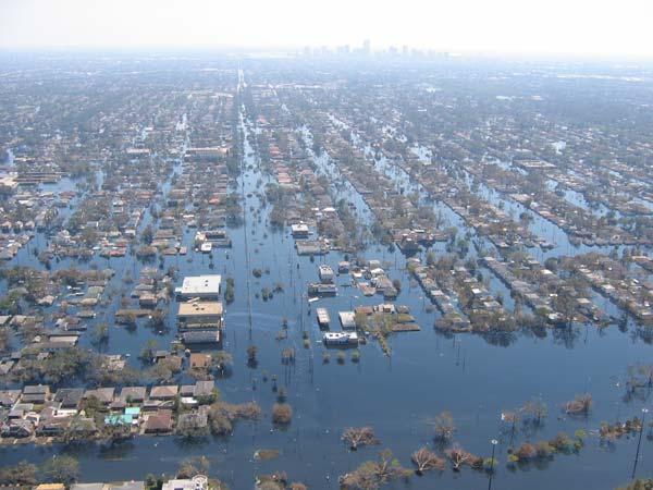
From June 1 through Nov. 30 each year, the coastal United States comes under threat from the ferocious winds and floodwaters of the hurricanes that form in the Atlantic Ocean basin.
Five years ago this week, one of the most devastating storms ever to hit U.S. soil, Hurricane Katrina, all but destroyed parts of New Orleans, as the surging ocean waters it pushed to land overtopped the city's protective levees, inundating a vast region, displacing millions of residents and killing more than 1,800 people. [Infographic: Hurricane Katrina History and Numbers]
While Katrina is the most remembered of these swirling storms — its name now infamous — it certainly isn't alone in causing significant death and destruction to areas of the United States. Following are eight of the most destructive storms in recorded U.S. history from 1900 until present day.
1900: The Galveston Hurricane
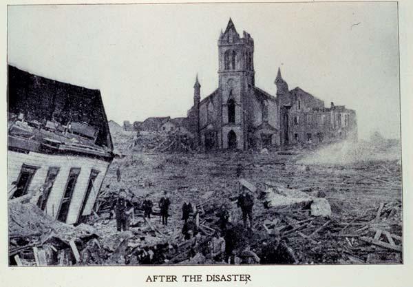
This hurricane was the deadliest weather disaster in U.S. history. It occurred before hurricanes and tropical storms were named and so is known instead by the place it hit.
Early on the evening of Sept. 8, 1900, a powerful Category 4 storm, with sustained winds of more than 130 mph (209 kph), roared ashore at Galveston, Texas.
Storm tides of 8 to 15 feet (2.4 to 4.6 meters) inundated the whole of Galveston Island, as well as other portions of the nearby Texas coast, according to a National Hurricane Center (NHC) historical account. These tides were largely responsible for the 8,000 deaths (estimates range from 6,000 to 12,000) attributed to the storm. The damage to property was estimated at $30 million.
The lack of weather forecasting and detection technology, such as the satellites and radar now used to track hurricanes, meant that there wasn't as much warning for Galveston residents as there would be for those in hurricane-prone areas now.
Get the world’s most fascinating discoveries delivered straight to your inbox.
However, warnings were issued by what was then known as the Weather Bureau. The real problem, according to a NOAA analysis: "Many didn't heed the warnings, preferring instead to watch the huge waves."
1928: San Felipe-Okeechobee Hurricane
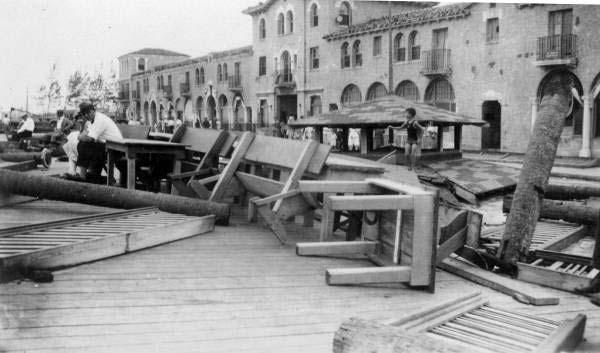
This hurricane, the second deadliest in U.S. history, hit near Palm Beach, Fla., on Sept. 16, 1928.
The storm caused extensive destruction. The worst tragedy occurred at inland Lake Okeechobee in Florida, where the hurricane caused a lake surge of 6 to 9 feet (1.8 to 2.7 m) that inundated the surrounding area. The lake surge was the main cause of the 1,836 deaths in the area.
No reliable wind readings are available from near the landfall area in Florida. However, Palm Beach reported a minimum barometric pressure of 27.43 inches, making this the fourth strongest hurricane of record to hit the United States. (The lower the barometric pressure at the center of a storm the more intense the winds.)
1935: Florida Keys Labor Day Hurricane
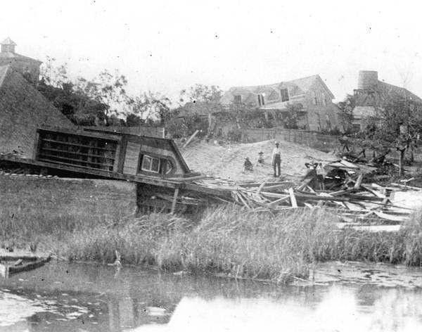
This hurricane, another that preceded the naming of storms, was small but vicious.
The storm formed to the east of the Bahamas on Aug. 29, 1935, became a hurricane on Sept. 1 and then underwent a rapid intensification before it struck the Florida Keys on Sept. 2 as a whopping Category 5 storm, one of only three Category 5 storms to hit the United States in the 20th century.
No wind measurements were made from the core of the storm, but a pressure of 26.35 inches measured at Long Key, Fla., makes this the most intense hurricane of record to hit the United States.
The combination of winds and tides generated by the storm were responsible for 408 deaths in the Florida Keys, primarily among World War I veterans working in the area. Damage in the United States was estimated at $6 million (1935 USD), which would work out to about $95 million in today's money.
1969: Hurricane Camille
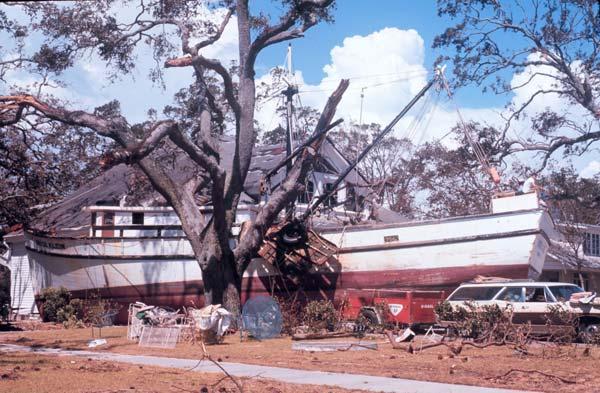
Before the trauma wrought by Katrina, the most memorable hurricane to hit the Gulf coast near Mississippi and Louisiana was probably Hurricane Camille, which struck along the Mississippi coast late on Aug. 17, 1969 as a Category 5 storm.
A minimum pressure of 26.84 inches was reported in Bay St. Louis, Miss., which makes Camille the second most intense hurricane of record to hit the United States. The actual maximum sustained winds will never be known, as the hurricane destroyed all the wind-recording instruments in the landfall area. The estimates at the coast are near 200 mph (320 kph). Columbia, Miss., located 75 miles (121 km) inland, reported 120 mph (193 kph) sustained winds.
A storm tide of 24.6 feet (7.5 m) occurred at Pass Christian, Miss.
The combination of winds, storm surges and rainfalls caused 256 deaths (143 on the Gulf Coast and 113 died in floods when the storm later passed over Virginia) and $1.421 billion in damage. Until hurricanes Andrew (in 1992) and Katrina, Camille was cited as the largest single act of destruction in U.S. history.
1989: Hurricane Hugo
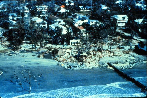
Hurricane Hugo was one of the worst storms ever to hit the coasts of the Carolinas, making landfall just north of Charleston, S.C., on Sept. 22 as a Category 4 hurricane.
Storm surges from Hugo inundated the South Carolina coast from Charleston to Myrtle Beach, with maximum storm tides of 20 feet (6 meters) observed in the Cape Romain-Bulls Bay area, the highest ever recorded on the East Coast.
A ship moored in the Sampit River in South Carolina measured sustained winds of 120 mph (193 kph). High winds associated with Hugo extended far inland, with Shaw Air Force Base, South Carolina (about 100 miles or 161 km inland) reporting 67 mph (108 kph) sustained winds with gusts up to 110 mph (177 kph).
Hugo was responsible for 21 deaths in the mainland United States, five more in Puerto Rico and the U. S. Virgin Islands, and 24 more elsewhere in the Caribbean. Damage estimates are $7 billion in the mainland United States and $1 billion in Puerto Rico and the U.S. Virgin Islands.
1992: Hurricane Andrew
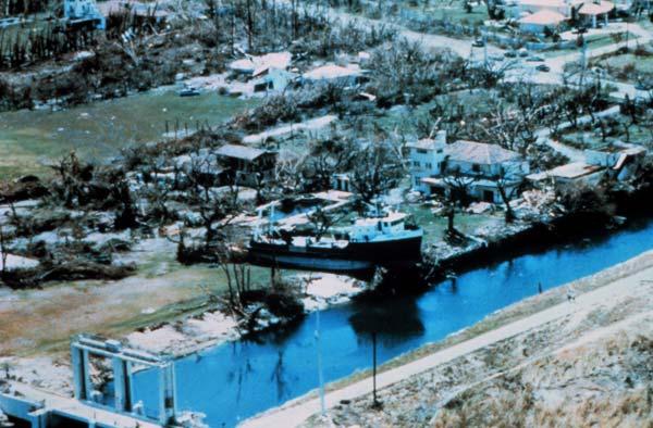
Until Hurricane Katrina, Andrew was the most damaging storm in U.S. history, causing $26.5 billion in damage, 23 deaths in the United States and three more in the Bahamas.
Most of the damage was caused by Andrew's monstrous winds, which are estimated to have been about 167 mph (269 kph) when it made landfall in Florida on Aug. 24, 1992, making it a Category 5 storm, the highest category on the Saffir-Simpson scale of hurricane strength. (Andrew was initially listed as a Category 4 storm at landfall, but a 2004 paper that re-analyzed the data bumped it up to a 5. Accurate estimates of the storm's strength were tricky to make, because the storm destroyed so many instruments when it hit.)
In the hardest hit areas of south Florida, Andrew reportedly destroyed 25,524 homes and damaged 101,241 others, according to the NHC. In Homestead, which was virtually obliterated by the storm, more than 99 percent of mobile homes were destroyed.
As bad as Andrew was, the havoc it wreaked could have been much worse if it was not a compact storm and if it had hit slightly higher on Florida's southeast coast — in this case, Miami and several other more densely populated areas would've been hit with unimaginable consequences.
2004: Hurricane Charley
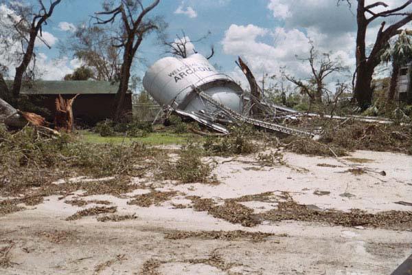
Charley was one of a barrage of hurricanes that hit Florida in 2004.
Charley was headed toward the southwest coast of Florida as a Category 2 storm when it rapidly intensified to a Category 4 storm — winds jumped from 110 mph (175 kph) to 145 mph (235 kph) — in the six hours before it slammed into Florida. Unprepared coastal communities, expecting a mild hurricane, instead experienced widespread destruction.
Charley made landfall with maximum winds near 150 mph (240 kph) on the southwest coast of Florida just north of Captiva Island around 3:45 p.m. ET. An hour later, Charley's eye passed over Punta Gorda. Both places were devastated by the storm's ferocious winds. The hurricane then crossed central Florida, passing near Kissimmee and Orlando. Charley was still of hurricane intensity around midnight when its center cleared the northeast coast of Florida near Daytona Beach.
Charley killed 10 people in the United States and caused an estimated $14 billion in damages, making Charley the second costliest hurricane in U.S. history.
Before striking Florida, Charley had already hit Cuba as a Category 3 storm.
2005: Hurricane Katrina
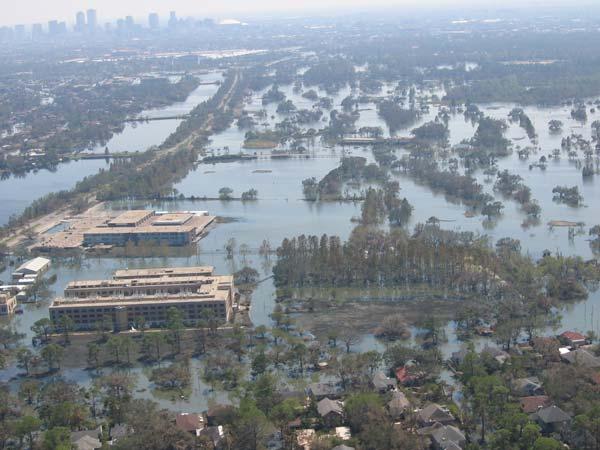
On Aug. 29, 2005, after passing over the Caribbean and Florida, Hurricane Katrina made landfall along the Gulf Coast as a Category 3 hurricane on the Saffir-Simpson scale with winds of 125 mph (201 kph).
Though it was not as strong as some of the other destructive storms that have hit the coast when it struck, Katrina had been a Category 5 the day before it hit land. That previous strength and its large footprint in the Gulf of Mexico created large swells in the ocean waters, resulting in a huge, unrelenting storm surge when the hurricane finally did hit.
Storm surge flooding of 25 to 28 feet (7.6 to 8.5 m) above normal tide level occurred along portions of the Mississippi coast, with storm surge flooding of 10 to 20 feet (3 to 6.1 m) above normal tide levels along the southeastern Louisiana coast.
Ultimately, this storm surge was responsible for much of the damage as it flooded coastal communities, overwhelmed levees, and left at least 80 percent of New Orleans underwater.
By the time the hurricane subsided, Katrina had claimed more than 1,800 human lives and caused roughly $125 billion in damages. It was the deadliest hurricane to strike the United States since the Palm Beach-Lake Okeechobee hurricane of September 1928.
 Live Science Plus


