It's quick and easy to access Live Science Plus, simply enter your email below. We'll send you a confirmation and sign you up for our daily newsletter, keeping you up to date with the latest science news.
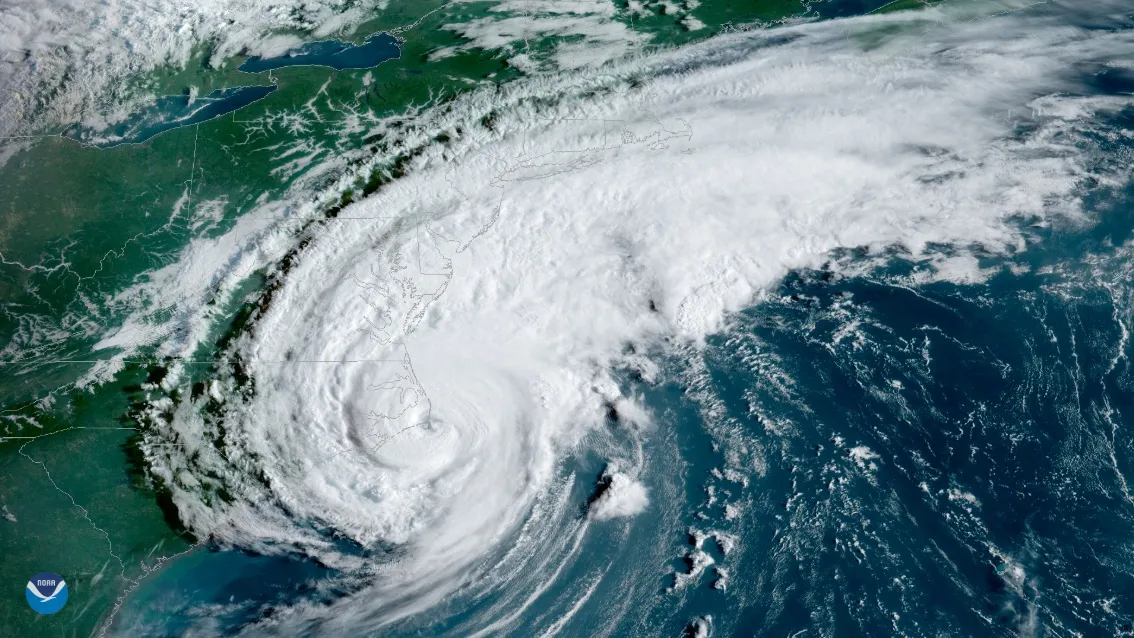
NOAA’s GOES East satellite captured this view of the strong Category 1 storm at 8:20 a.m. EDT, just 15 minutes before the center of Hurricane Dorian moved across the barrier islands of Cape Hatteras.
Hurricane Dorian made landfall this morning (Sept. 6) on the barrier islands of North Carolina's Cape Hatteras, carrying with it what the National Hurricane Center (NHC) called a "life-threatening storm surge and dangerous winds," as well as the risk of flash flooding.
The large storm's winds have lessened significantly since it brutalized the Bahamas last weekend as one of the most powerful hurricanes ever measured. But weather stations on the Carolina coast recorded serious sustained winds of 74 mph (119 km/h) and gusts up to 92 mph (148 km/h), according to an 11 a.m. EST advisory from the NHC.
Water, not wind, remains the most serious danger from the storm. The NHC has already reported a major storm surge, over 5 feet (1.5 meters), in North Carolina. The agency shared alarming images of the floodwaters online.
We're getting some pictures and videos of the severe flooding due to storm surge on the Outer Banks. This is Ocracoke, NC. Our hearts go out to ALL impacted by #Dorian. #nws pic.twitter.com/OAVxjJkUjjSeptember 6, 2019
The storm will impact the North Carolina coast, southeastern Virginia and Chesapeake Bay "for the next several hours," according to the NHC, with the most severe flash flood risks in North Carolina and far-southeastern Virginia.
Forecast path of Hurricane Dorian on Sept. 6, 2019.
(Image credit: National Hurricane Center)
The NHC issued tropical storm warnings for parts of Delaware and coastal Massachusetts and Maine, which may face the outer bands of the storm Saturday as it continues to power its way north through the Atlantic.
The next place to deal with hurricane-force winds from Dorian's core is Canada's Nova Scotia, where the eye should arrive by late Saturday. The NHC also issued warnings for Prince Edward Island and Newfoundland.
Sign up for the Live Science daily newsletter now
Get the world’s most fascinating discoveries delivered straight to your inbox.
A large region of Canada's maritime region may face significant rainfall, flood risk and wind, according to the Canadian Hurricane Centre (CHC). The CHC's forecast warns of dangerous storm surge along the Atlantic coasts of Nova Scotia, Prince Edward Island and Newfoundland, noting that the storm could remain a hurricane as it passes north through Newfoundland.
If you live in one of the Canadian provinces threatened by the coming storm, the time to start preparing is now, according to the NHC.
Tia is the editor-in-chief (premium) and was formerly managing editor and senior writer for Live Science. Her work has appeared in Scientific American, Wired.com, Science News and other outlets. She holds a master's degree in bioengineering from the University of Washington, a graduate certificate in science writing from UC Santa Cruz and a bachelor's degree in mechanical engineering from the University of Texas at Austin. Tia was part of a team at the Milwaukee Journal Sentinel that published the Empty Cradles series on preterm births, which won multiple awards, including the 2012 Casey Medal for Meritorious Journalism.