Will there be a La Niña this fall? Here's what forecasters predict and what it means for the weather
NOAA forecasts suggest we could experience La Niña conditions in the fall and early winter. However, this potential La Niña spell is unlikely to break records.


La Niña conditions could develop in the fall and early winter, but they will probably be weak and short-lived, forecasters say.
La Niña is the cold phase of the El Niño-Southern Oscillation (ENSO), a natural climate pattern of atmospheric and sea temperature changes in the tropical Pacific Ocean. During La Niña, the jet stream shifts northward, bringing wetter conditions and cooler winters to the northern U.S., while the southern U.S. experiences drier conditions and warmer winters. A La Niña also tends to ramp up hurricane activity over the Atlantic.
Conditions for this phase briefly developed last winter, but they didn't stick around long enough to be considered an official La Niña event in the historical record. The latest ENSO forecast from the National Weather Service indicated that we could be in for something similar in the coming months.
A period of La Niña conditions is favored for the fall and early winter, and there's a 21% chance that the current July-to-September period will qualify. The likelihood then rises to more than 50% for overlapping 3-month periods between September and January. Still, forecasters aren't expecting massive weather shifts.
"If La Niña forms, it's likely to be weak, meaning La Niña wouldn't exert a strong influence over the winter," Emily Becker, a research professor at the University of Miami and lead writer of the National Oceanic and Atmospheric Administration's ENSO blog, told Live Science in an email.
Related: Watch Hurricane Erin reach Category 5 strength in a blaze of lightning
The ENSO cycle triggers a warm El Niño phase and then a cold La Niña phase every two to seven years, on average, with each phase lasting around nine to 12 months. However, the timing of these phases varies, and they're difficult to predict.
Get the world’s most fascinating discoveries delivered straight to your inbox.
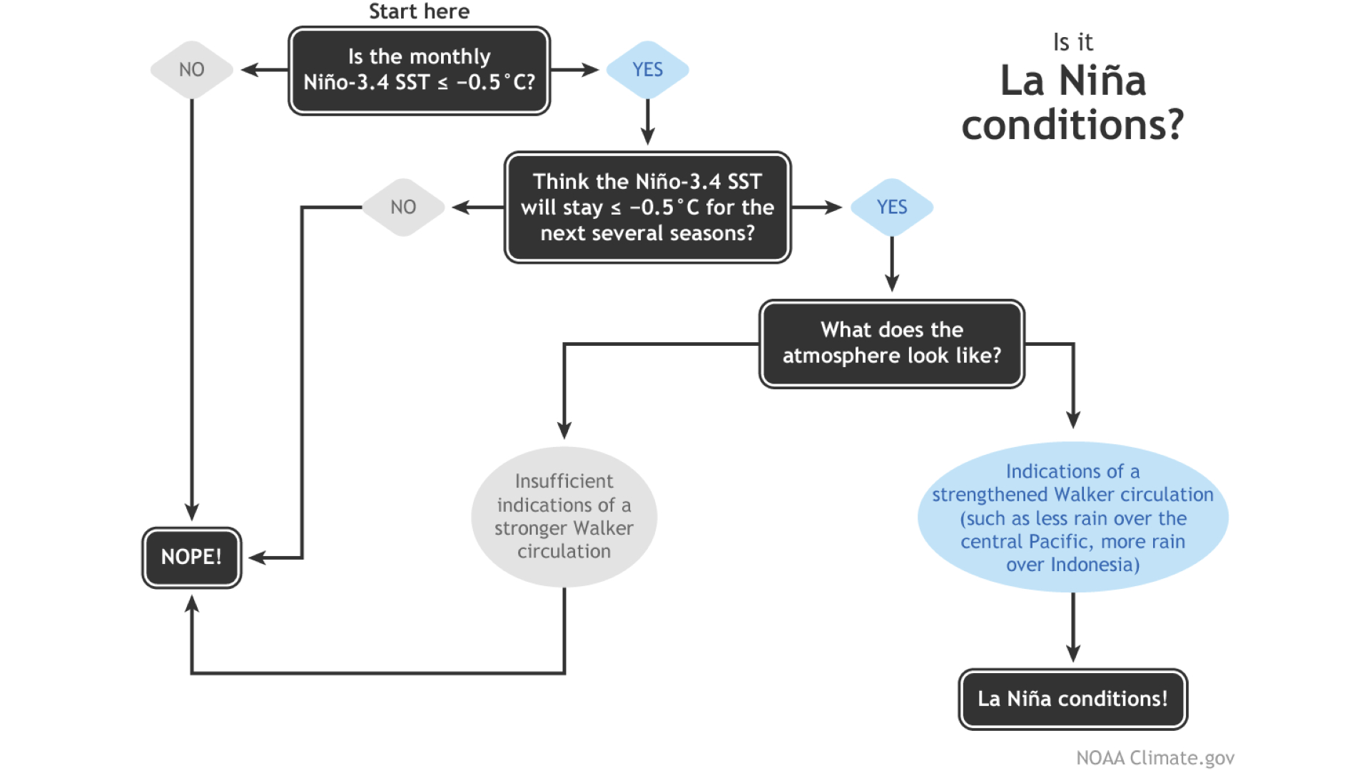
The phases are defined by changes in the sea surface temperature of the Niño region of the east-central Pacific and a shift in atmospheric conditions, which impact the Pacific jet stream. El Niño conditions occur when the sea surface temperature is 0.9 degrees Fahrenheit (0.5 degrees Celsius) higher than the long-term average, while La Niña conditions happen when the sea surface temperature falls 0.9 F below the long-term average.
We were due to enter a La Niña last summer, but the conditions didn't develop until December. That delayed start meant that La Niña didn't have time to gain strength before the onset of winter.

NOAA has a flowchart for declaring La Niña.
Last year's warmer-than-average ocean temperatures might have played a role in the delay. Earth was in an El Niño between May 2023 and March 2024, which contributed to record-breaking heat during that period. However, the planet has continued to warm with climate change, regardless of what ENSO is doing.
RELATED STORIES
Last winter's La Niña spell didn't make it into the record books because the temperature didn't remain below the 0.9 F threshold for at least five consecutive overlapping seasons — periods of three months. The latest data suggest that La Niña conditions are more likely than not in just three of these upcoming periods across the fall and winter, and thus any spell is unlikely to be an official La Niña.
"It's very possible we'll end up with another winter like 2024-25, with a few months of La Niña conditions, not quite enough to qualify as a La Niña event in our historic record," Becker said. "However, last winter's impacts ended up looking like those we'd expect during a moderately strong La Niña."

Patrick Pester is the trending news writer at Live Science. His work has appeared on other science websites, such as BBC Science Focus and Scientific American. Patrick retrained as a journalist after spending his early career working in zoos and wildlife conservation. He was awarded the Master's Excellence Scholarship to study at Cardiff University where he completed a master's degree in international journalism. He also has a second master's degree in biodiversity, evolution and conservation in action from Middlesex University London. When he isn't writing news, Patrick investigates the sale of human remains.
You must confirm your public display name before commenting
Please logout and then login again, you will then be prompted to enter your display name.

 Live Science Plus


