


Ancient Scratched Stones: World's Earliest Maps or Magic Artifacts?
A set of broken stones covered with etchings of lines and squares, discovered at a 5,000-year-old sacred site in Denmark, may be some of humankind’s earliest maps, according to archaeologists.
The researchers think the inscribed stones are symbolic maps of local landscapes, and were perhaps used in rituals by Stone Age farmers who hoped to magically influence the sun and the fertility of their farmlands.
Fragments of 10 of the "map stones" or "landscape stones" were found in June, during excavations of a round, earth-walled enclosure at the Vasagard archaeological site on Bornholm, a Danish island in the Baltic Sea. [See Photos of the Scratched "Map Stones" Found in Denmark]
Excavations of the enclosure since the 1990s have found hundreds of broken flat stones inscribed with patterns of radiating straight lines, called "sun stones" or "solar stones" ("solsten"in Danish). Archaeologists have said these artifacts are likely from the rituals of a Neolithic sun-worshipping religion that existed about 5,000 years ago.
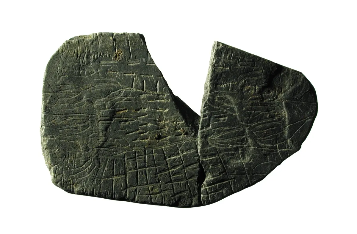
But the map stones are inscribed with squares and lines that look like fields, fences and plants, said archaeologist Flemming Kaul, the curator and senior researcher in prehistory at the National Museum of Denmark.
"There was one particular stone that seems to be rather complicated, and we all agree that it looks like some sort of a map — not a map in our modern sense, but a stylized map," Kaul told Live Science. "And I could see some similarities with rock carvings from the Alps in northern Italy, dated to the same period of time, which are interpreted as symbolic landscapes — and that is what I believe we have found now."

Sacred territory
The most detailed of the newly discovered map stones went on display in October at the Moesgaard Museum in Aarhus, Denmark. It measures about 2 inches (5 centimeters) across, and has been broken into three pieces. One triangular piece has not yet been found, the researchers said.
Get the world’s most fascinating discoveries delivered straight to your inbox.
"That is one that seems to be very complex, with different sorts of fields, and something which looks like plants, which could be a symbol for a crop like barley, and other details that look like fences," Kaul said. "And it's fascinating that even though it's so small, you can certainly see that these patterns have been very deliberately made."
Kaul said the stone was probably crushed during an ancient ritual, like what the researchers saw with many sun stones also found at the site. The pieces were then deposited in the rings of ditches that surround the sacred enclosure sometime between 2900 B.C. and 2700 B.C., according to the archaeologists.
"Often when ritual objects have had a certain life cycle, then they are deposited at a sacred place, perhaps also to enhance the magic of the ritual which has just been performed with them," Kaul said. "And of course, when they are broken, then they are not working more in the human world — but they are still working in another [spirit] world, by being placed in the ditches of these sacred sites."
Kaul thinks the map stones and sun stones from Bornholm were used together in ceremonies to influence the effects of the sun on the fertility of a particular piece of land.
"[T]hey could have passed the sun images over the small field images in order to enhance some magic, which could give the sun more light, for example, such as in the spring, when the sun should give more light so that crops can grow," he added.
Here comes the sun
Kaul sees a link between the evidence for solar rituals at Bornholm and evidence of similar beliefs elsewhere in Neolithic Europe, a time of transition from nomadic hunter-gatherer groups to settled farming communities.
"Sun images must have something to do with a solar cult — and we have many other European indications of that, such as Stonehenge in England from about the same time, and passage graves in Ireland that are oriented towards the midwinter sunrise. And now we have these early pictures of the sun in Denmark," he said.
He also noted the similarities between the map stones from Denmark and rock carvings in the Val Camonica and other Alpine regions of northern Italy and France, which have been interpreted by archaeologists as symbolic farm landscapes used in Neolithic rituals.
"The Italian archaeologists give these square features that they interpret as fields the name of 'topographical elements' — so it is not a map in our modern sense, but it is somehow a rendering of fields and field systems," Kaul said. "And so it is very interesting to find these topographical elements here in Scandinavia, and in this minute form."
The similarities are not evidence of direct contact throughout Europe 5,000 years ago, but they could reflect common ideas among Neolithic farming peoples about the sun and the fertility of their lands, he said.
"When you also look at the Italian material, then it gives you a feeling that these map stones are not just isolated phenomenon — but that we are looking at a trend of a general European development here, and also in a religious or spiritual sense," Kaul added.
An article about the map stones from the Vasagaard enclosure on Bornholm, written by archaeologists Jens Andresen of Aarhus University and Michael Thorsen of the Bornholm Museum, was published in October in the Danish archaeological magazine Skalk.
Kaul accepts that the interpretation of the map stones could be controversial: "About 20 years ago, after the first solar stones were found, I wrote about it for Skalk – and even the editor of the magazine didn't believe it," he said. "And now, after 20 years, we have found more than 200 solar stones, and they are one the most important things from Bornholm … so let's wait a couple of years to see if there are more map stones to come."
Original article on Live Science.
Tom Metcalfe is a freelance journalist and regular Live Science contributor who is based in London in the United Kingdom. Tom writes mainly about science, space, archaeology, the Earth and the oceans. He has also written for the BBC, NBC News, National Geographic, Scientific American, Air & Space, and many others.