


Photos: 5,000-Year-Old Scratched Stones Could Be Ancient Maps
History

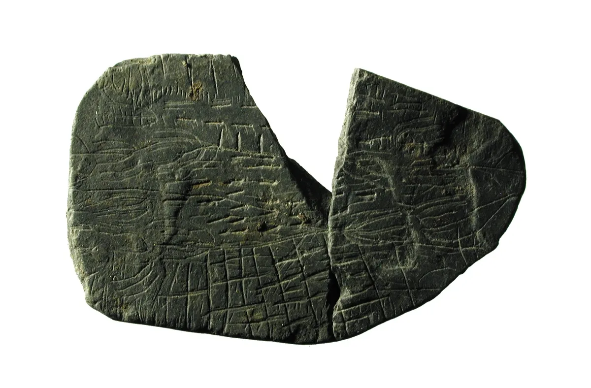
Is this one of the world's oldest maps?
The lines scratched on this 5,000-year-old stone fragment from the Vasagard archaeological site, on the island of Bornholm in Denmark, may be one of the earliest symbolic representations of fields and farmland, archaeologists said. In addition to these "map" stones, archaeologists have found spider stones, inscribed with patterns that resemble a spider web. [Read full story about the scratched stones and the more recently discovered spider stones]
Map stones

Archaeologists and students from Denmark and Poland discovered 10 of the map stones or "landscape stones" during excavations at Vasagard in June. [Read full story about the scratched stones]

Ancient stones

The map stones were excavated from the circular ditches that surround a 5,000-year-old, earth-walled enclosure at the Vasagard archaeological site.
The stones have been dated to between 2900 B.C. and 2700 B.C., during the late Stone Age period in Europe.
Sun stones

Excavations at Vasagard since the 1990s have uncovered hundreds of broken stones inscribed with patterns of radiating lines, called solsten in Danish, which means "sun stones" or "solar stones."
Archaeologists think the site was a sacred enclosure for a Neolithic sun-worshipping religion or "solar cult."
Get the world’s most fascinating discoveries delivered straight to your inbox.
Superstition

Most of the sun stones from Vasagard have also been broken, probably after they were used to symbolize the sun in magical rituals designed to ensure the fertility of local farmlands, the researchers said.
Local area

Archaeologists think the so-called map stones found at Vasagard could represent areas of local farmland, such as the fields farmed by a particular clan or community.
Some of the stones are marked with what appear to be symbols of plants. This one may show barley or einkorn wheat, which were grown in the area during the Neolithic period.
Ancient rituals
The researchers think the map stones and sun stones from Vasagard were ritually broken and deposited at the sacred enclosure after they were used together in rituals.
As well as an appeal to the sun to fertilize their farmlands, the rituals may have been seen as a sacred guarantee of the right of a community to a farm in a particular area.
Finding history

The map stones were found by archaeology students from Aarhus University in Denmark and Warsaw University in Poland, under supervision by archaeologists from the Bornholms Museum, the Moesgaad Museum at Aarhus, and the National Museum of Denmark.
This image shows some of the students with Aarhus University archaeologist Jens Andresen, at right.
Weapons, too

As well as the Neolithic map stones and several more sun stones, the archaeology students from Aarhus and Warsaw found this polished stone axe or war hammer during the excavations at the Vasagard site in June.
Similarities

Archaeologists say the map stones found at Vasagaard are similar to some rock carvings in the alpine Val Camonica region of northern Italy, which have also been interpreted as symbolic landscapes that were used in Neolithic rituals. [Read full story about the scratched stones]
Earthen enclosure

The archaeological site at Vasagard on the Danish island of Bornholm features a round, earthen-walled enclosure that researchers think was a ceremonial center for Neolithic sun worshippers about 5,000 years ago. It includes two main excavation areas on each side of a stream valley, known as Vasagard West and Vasagard East.
Tom Metcalfe is a freelance journalist and regular Live Science contributor who is based in London in the United Kingdom. Tom writes mainly about science, space, archaeology, the Earth and the oceans. He has also written for the BBC, NBC News, National Geographic, Scientific American, Air & Space, and many others.