It's quick and easy to access Live Science Plus, simply enter your email below. We'll send you a confirmation and sign you up for our daily newsletter, keeping you up to date with the latest science news.
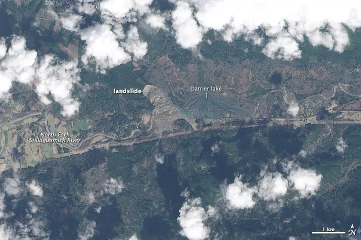
The Operational Land Imager (OLI) aboard Landsat 8 acquired this image on March 23, 2014, showing the devastation from a landslide that struck near Oso, Wash.
The scar of the deadly landslide that devastated a small community near Oso, Wash., over the weekend can be seen from space.
This satellite image was snapped by the Operational Land Imager (OLI) aboard Landsat 8 on Sunday (March 23), a day after the 1-square-mile (2.5 square kilometers) landslide left a trail of debris and destruction. For comparison, NASA's Earth Observatory also released an image showing the same area taken earlier this year, on January 18.
This satellite image shows the area near Oso, Wash., on Jan. 18, 2014, two months before the landslide.
(Image credit: NASA Earth Observatory)
An unstable, rain-soaked hillside collapsed on the bank of the Stillaguamish River about 50 miles (80 km) north of Seattle on Saturday (March 22), unleashing about three times the volume of mud as there is concrete in Hoover Dam, The New York Times reported.
Nearly 50 homes were buried in the so-called Steelhead Drive neighborhood and at least 16 people were confirmed dead by Snohomish County officials. But the death toll may rise, as search efforts for the dozens more reported missing turn bleak. [See Photos of the Landslide's Destruction]
The hillside had a history of landslides, including one in 2006 that blocked the Stillaguamish River. Fifteen years ago, the U.S. Army Corps of Engineers issued a report that warned of "the potential for a large catastrophic failure," the Yakima Herald reported.
Landsat 8, which launched into space a year ago, is the latest in a series of satellites that have been monitoring the changing face of Earth for more than 40 years. The Landsat program is a collaboration by NASA and the U.S. Geological Survey. It started in 1972 and its satellites have documented countless long- and short-term events, including the expansion of urban sprawl around Las Vegas, the loss of rainforests around Brazil and smoke rising from Lower Manhattan after the 9/11 terror attacks.
Megan has been writing for Live Science and Space.com since 2012. Her interests range from archaeology to space exploration, and she has a bachelor's degree in English and art history from New York University. Megan spent two years as a reporter on the national desk at NewsCore. She has watched dinosaur auctions, witnessed rocket launches, licked ancient pottery sherds in Cyprus and flown in zero gravity. Follow her on Twitter and Google+.