It's quick and easy to access Live Science Plus, simply enter your email below. We'll send you a confirmation and sign you up for our daily newsletter, keeping you up to date with the latest science news.
The way radio signals from GPS satellites bounce around during storms can now help scientists deduce wind speeds in hurricanes, insights that could help better predict the severity of the storms and where they might be headed.
Orbiting thousands of miles above Earth, global positioning satellite (GPS) networks constantly beam radio signals at the ground that reveal both where each satellite is and when the message was sent. These satellites thus serve as points that GPS receivers can refer to in order to calculate their own position.
Radio waves can bounce off surfaces much like how visible light reflects off mirrors. Approximately 60 percent of the radio signals from GPS satellites reflect off bodies of water such as the ocean and back at the sky. However, unlike mirrors, the surface of the ocean is rarely calm and flat — wind blowing over bodies of water generates waves.
"Imagine you blow on a hot bowl of soup," said researcher Stephen Katzberg, a research engineer at NASA Langley Research Center in Hampton, Va. "The harder you blow, the bigger the waves are in the bowl."
When GPS signals ricochet off a wave, the rough surface of the water distorts the reflection by scattering the signals in a variety of directions. By analyzing this distortion, Katzberg and his fellow researchers can reason how rough the water is and thus how strong the wind is blowing.
"The GPS system for navigation contains all the elements of remote sensing. You just need to look at it the right way," Katzberg told LiveScience.
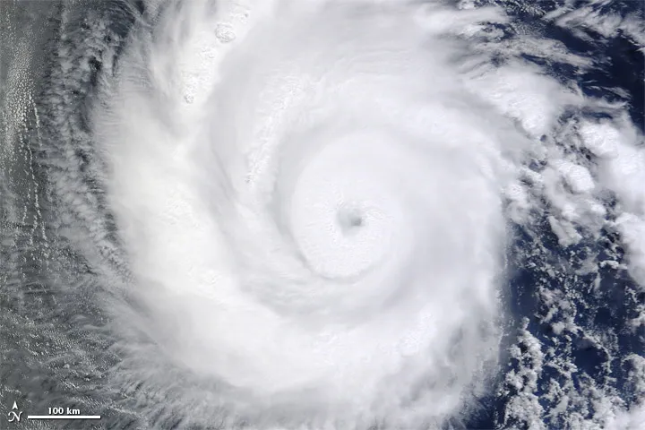
The eye of Hurricane Earl was clearly visible during a NASA hurricane hunter flight through the storm in 2010.
(Image credit: NASA/Jane Peterson)
Currently, scientists measure hurricane wind speeds by dropping a tube packed with scientific instruments into storms. These packages, called dropsondes, are strapped to small parachutes, jettisoned from airplanes and gather data as they fall. Each device measures pressure, humidity and temperature in addition to wind speed.
Sign up for the Live Science daily newsletter now
Get the world’s most fascinating discoveries delivered straight to your inbox.
The storm-hunting airplanes of the National Oceanic and Atmospheric Administration (NOAA), nicknamed Hurricane Hunters, typically drop about 20 single-use dropsondes, each costing about $750, into each storm. The new GPS-based method of measuring wind speed could provide a far more extensive view of a storm's wind speeds for a much lower cost. [In Images: NASA's Hurricane Hunters]
The GPS-based system involves GPS receiver chips located in aircraft. A computer compares radio waves coming directly from satellites above with reflected signals from the sea below and calculates an approximate wind speed with accuracy that's within 11 mph (18 km/h). For comparison, the wind speed of a midrange, Category 3 hurricane is about 123 mph (200 km/h).
Since the dropsondes are expensive, they are released in a spread-out pattern, and meteorologists need to use some guesswork to fill in the gaps. In comparison, the GPS-based method can constantly gather data about the wind below.
"You were already going to have these GPS systems onboard, so why not get additional information about the environment around you," Katzberg said.
Complementary systems
The GPS-based technique does have drawbacks, Katzberg cautioned. For instance, dropsondes currently provide wind speed measurements that are 10 times more precise than those from GPS. In addition, since the GPS-based method requires large bodies of water to work, it cannot be used over land. Moreover, in cases where the ocean's surface is choppy without any wind, such as the eye of a stormhurricane, Katzberg said other tools are needed to get an accurate wind speed measurement.
"The GPS technique, while useful as it has been shown to be, has practical limits as well," Katzberg said.
The ultimate goal of this GPS-based method is not to replace dropsondes, but to add a much broader view of wind speeds to the data the dropsondes provide. As GPS satellites improve, "wind speed detection by GPS can ultimately approach dropsonde accuracy, but the two measure mostly different things," Katzberg said.
The new system is currently getting tested during flights on Hurricane Hunters. It may also be implemented on satellites in the future, Katzberg said — in 2016, NASA plans to launch a system of small satellites called the Cyclone Global Navigation Satellite System (CYGNSS) to measure reflected GPS satellite signals from low orbit to monitor storm wind speeds from space.
Radio waves from other kinds of satellites might help too, Katzberg said, including reflections of powerful satellite broadcasts from DirecTV and Sirius XM Radio.
"Those signals are extremely powerful and easy to detect," Katzberg said. "These satellites cost hundreds of millions or even billions of dollars, but our system only costs a few hundred. We're taking advantage of the expensive infrastructure that's already there."
Katzberg and his colleagues Jason Dunion and George Ganoe detailed their findings online June 1 in the journal Radio Science.
Charles Q. Choi is a contributing writer for Live Science and Space.com. He covers all things human origins and astronomy as well as physics, animals and general science topics. Charles has a Master of Arts degree from the University of Missouri-Columbia, School of Journalism and a Bachelor of Arts degree from the University of South Florida. Charles has visited every continent on Earth, drinking rancid yak butter tea in Lhasa, snorkeling with sea lions in the Galapagos and even climbing an iceberg in Antarctica.

 Live Science Plus