
 Live Science Plus


Why Do We Care So Much About El Niño?

Every month since March, when the first El Niño Watch was issued, forecasters, government officials around the world, and yes, even those in the media, have been watching with bated breath to see whether various climate agencies would officially pronounce the arrival of that infamous climate phenomenon. So far, no clear-cut El Niño has been declared, but that hasn’t stopped the continual updates and dissections of the most recent seasonal forecasts and trends in ocean temperatures and winds, as if they were the latest juicy plot twist on “Scandal” or “Game of Thrones.”
If you aren’t among those obsessively tracking Kelvin waves and the Nino3.4 region — and the next “official” update is expected on Aug. 7 — you may wonder what all the fuss is about. After all, El Niño is just the warming of ocean watersin the tropical Pacific. So why the heck do we care so much about it?
We care because this seemingly isolated event is just one part of the global climate system and can actually have major influences on the weather and climate around the world, from the U.S. to Australia to eastern Africa. For example, El Niño shifts atmospheric patterns in a way that typically brings more rain to the southern U.S., but drought to Indonesia. Those changes can, in turn, have economic and health consequences, such as altering the crop yields in agricultural markets or providing a more conducive environment for the spread of malaria. Because of these impacts, groups at the U.S. National Centers for Environmental Prediction, or NCEP (which is part of the National Oceanic and Atmospheric Administration), the Australian Bureau of Meteorology, and other organizations around the world watch the changing conditions in the Pacific Ocean and make forecasts for whether and when an El Niño might develop.

How Will We Know When El Niño Finally Arrives? El Niño Expected to Limit 2014 Hurricane Season Long Wait Continues as El Niño Lagging
El Niño also leads to warmer average global temperatures, which come atop the underlying trend of rising temperatures spurred by global warming. The only year in the top 10 warmest globally that wasn’t during the 21st century was 1998, when one of the strongest El Niños on record was in force.
Not all of El Niño’s effects are negative: The atmospheric changes it spurs tend to tamp down on tropical cyclones and hurricanes in the Atlantic Ocean basin, something denizens of the Caribbean and Gulf and East coasts of the U.S. surely appreciate.
“In an El Niño year, you have winners and losers,” Walter Baethgen, a senior research scientist with the International Research Institute for Climate and Society at Columbia University’s Earth Institute, said in an IRI video.
Get the world’s most fascinating discoveries delivered straight to your inbox.
Exactly what impacts are seen and when they emerge can depend on the timing of an El Niño — the current event is expected to emerge late this summer or early in the fall. But even while one is building, it can still influence weather conditions, as this event seems to be doing. The strength that a full-blown El Niño achieves can also affect the impacts it brings — for example, the excess rains that parched California so desperately needs seem only to be a feature of a strong El Niño.
“There is a lot of variety in exactly how strong they get, exactly what month they begin, or are identified as El Niño events, as well as the exact month in which they peak,” said IRI director Lisa Goddard during a press call held by the climate communication group Climate Nexus. “So all of these differences can influence (El Niño’s) regional climate impacts.”
What Is El Niño?
El Niño is a cyclical climate phenomenon that occurs every 3 to 5 years (though that return period can be as short as 2 and as long as 7 years). It’s defining characteristic is the buildup of warmer-than-normal surface waters over the eastern and central tropical Pacific Ocean. (This warm phase is part of a larger cycle called the El Niño-Southern Oscillation that also has a neutral phase and a cold phase, called La Niña.)
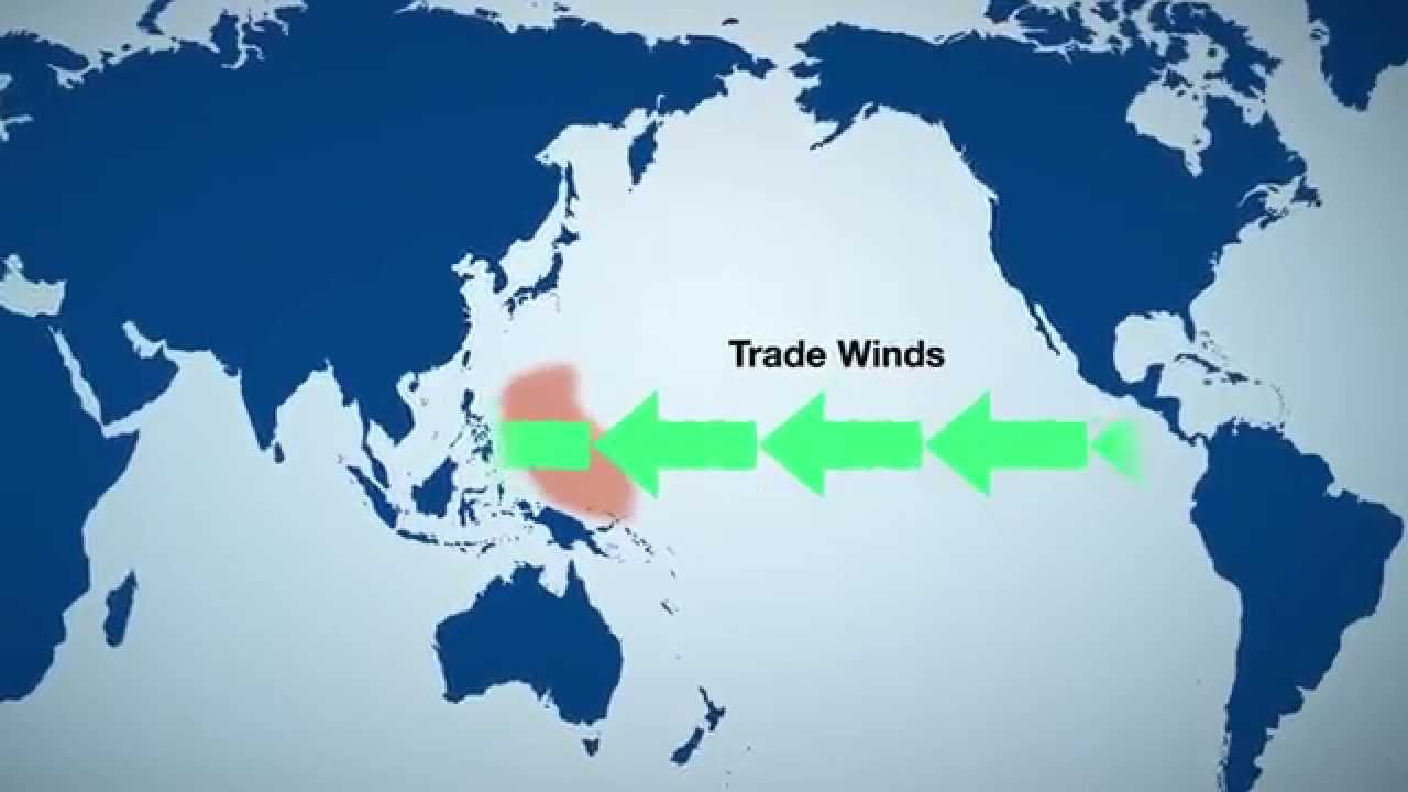
These warmer waters are linked to — or coupled with, as atmospheric scientists say — changes in the trade winds over the region. In neutral conditions, these winds blow from east to west across the basin, piling up the warm water in the western portion of the basin, near Indonesia. But during El Niño, the winds relax, and the warm water slides back east, like a ball rolling down a hill.
The warm water fuels thunderstorms in the atmosphere overhead, which in turn warms the atmosphere through a process called latent heating. The shift in where the warm water is and the increase in the heat the ocean releases cause a shift in this storminess and heating, which affects one of the main circulations of the atmosphere, the Hadley circulation. The Hadley circulation features air rising near the equator and traveling toward higher latitudes where it sinks and flows back to the equator. The increased heat from El Niño turbocharges the poleward flow, which in turn causes further changes in atmospheric flow, including to the jet stream over the Pacific.

“The phenomenon itself is specific to the tropical Pacific, even though it does have worldwide impacts,” Goddard said during the press call.
While the atmospheric conditions with the current anticipated event haven’t yet shaped up to the point that NCEP and IRI forecasters are willing to officially declare an El Niño, they still place an 80 percent chance on one happening by late fall.
“It’s fairly confident, but it’s not a slam dunk,” Anthony Barnston, IRI’s chief forecaster, told Climate Central.
Teleconnections
Not every place in the world is affected by El Niño, and not every El Niño produces the same effects as previous ones. But “there are places that have fairly reliable” climate effects, orteleconnections, Barnston said.
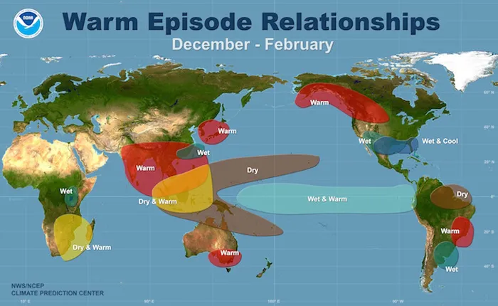
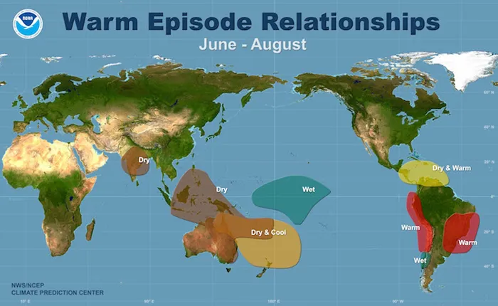
The most robust effects are precipitation-related. Both Indonesia and northern South America typically see below-normal rains that can lead to drought, while more rain is typically seen over southeastern South America, eastern equatorial Africa and the southern U.S.
The above-average rainfall in the southern U.S. is linked to the changes in the jet stream, as it tends to funnel more storms over the region.
There is interestingly one tiny area of northern South America, along the coasts of Ecuador and Peru, that actually sees increased rainfall. The rains are driven by the warmer waters just off the coast as they fuel storm activity. Such rains were actually seen earlier this spring when a particularly warm blob of water worked its way over to the eastern Pacific and fueled storms.
Not all of the changes linked to El Niño always occur: El Niño is linked to a less active monsoon over India, leading to drought conditions there, but this effect was missing during the 1997-1998 El Niño, one of the strongest on record. (The monsoon has been lackluster so far this year, but it’s unclear whether or not that’s related to the burgeoning El Niño, Barnston said.)
“So there is an expectation of certain ENSO impacts, but there’s not a guarantee, and so that’s where seasonal forecasts become very important,” he said.
El Niño can also lead to temperature changes, with the northern tier of the U.S. tending to be warmer than normal and the southern tier cooler. The latter effect is related to the increased precipitation, which tends to moderate temperatures, while the former is linked to the stronger jet stream (and is the more robust of the two connections). The more intense flow tends to fence off cold Arctic air, keeping incursions like last winter’s Polar Vortex episodesfrom impacting the northern parts of the country.
The temperature effects of El Niño go beyond trends in particular regions. The heat released from the oceans bumps up the planet’s average temperature, in addition to the warming caused by the heat trapped by accumulating greenhouse gases in the Earth’s atmosphere. (The tendency toward cooler conditions in the Pacific over the past couple of decades could be the main driver of the slowdown in the rate of warming over the same time period, as such conditions cause the ocean to store more of that building heat.)
“The state of the tropical Pacific can really affect global temperatures just through the fact that you’re getting all this ocean heat either absorbed or released,” Gerald Meehl, a senior scientist with the National Center for Atmospheric Research in Boulder, Colo., said during the same press call as Goddard.
Even a moderate El Niño, like the one that arose in 2010, can raise global temperatures — 2010 was, in fact, the warmest year on record. If the current El Niño is commensurate with the 2010 one, global temperatures will likely top those in 2010 because they will add a similar amount of heat on top of the already warmer background created by global warming, Goddard said.
All in the timing
The biggest impact to global temperatures tends to come about two to four months after an El Niño peaks, which typically happens during the Northern Hemisphere winter. (An El Niño event usually peters out by March of the year after it develops.) That background seasonal climate helps determine what the impacts of the El Niño are.
“The seasonality -- what the weather and the climate is typically at that time of year -- is important to how ENSO impacts it,” Goddard said. So knowing when El Niño will kick in is key to anticipating economic and societal impacts.
In general, most of the impacts of El Niño come during its winter peak, particularly for the U.S. That’s because the Pacific jet stream is weaker in the summer, so any changes to it make less of a difference than for the stronger winter jet stream, said NCEP forecaster Michelle L’Heureux.
Californians are hoping that the El Niño will bring enhanced winter rains, to make up for the disappointing rainy seasons of the past 3 years, which has left the entire state in high levels of drought. But the El Niño rains in Southern California are best correlated with strong El Niños. Right now it is not expected that this one will be strong, but even a moderate El Niño could mean that the area sees something closer to a normal rainy season, Barnston said.
Some places do see their biggest impacts outside of the Northern Hemisphere winter: Dryness that can affect Africa’s Sahel and damage agriculture there tends to occur from July to September (meaning the area could avoid much of this impact if the El Niño doesn’t fully develop soon).
In general, the Southern Hemisphere tends to see more year-round effects than the Northern Hemisphere, L’Heureux said, because El Niño peaks during their summer, though their strongest effects also come during their winter.
The impacts in Southern Hemisphere locales like Australia and Indonesia are also more instantaneous than those in the U.S. because of their proximity to the region where El Niño originates. They also see stronger, more robust impacts.
The drier conditions typically seen in both of those spots can increase the odds of damaging wildfires, which come along with economic costs, as well as impacting crop yields. If, for example, drought reduces the Australian wheat crop, that can affect the availability of wheat in food markets as well as food prices, Baethgen said in the IRI video (though wheat from areas that see more rain could offset this). Countries like the U.S. are more resilient in the face of such effects than places like Mozambique, whose agriculture is sensitive to El Niño’s Southern Hemisphere summer effects, Barnston said. Forecasting can help such vulnerable societies prepare for these impacts.
Places that see more rain could see negative as well as positive impacts. A little rain can be helpful in places like southeastern South America, but too much can expose crops to disease. Excessive rains can also have health impacts: In Kenya during the 1998 El Niño, rains caused catastrophic flooding that seriously damaged health infrastructure and spread malaria and Rift Valley fever.
Those impacts are why forecasters like Barnston, Goddard, and L’Heureux are working to better predict El Niños and understand the climate impacts they have. It is also why places like the IRI and the World Meteorological Organization are working to disseminate what we do know about El Niño and improve communication and coordination between meteorologists and government agencies and officials who would need to prepare for potential impacts.
“There have been major improvements in the understanding of El Niño, its climate effects and associated impacts over the past several decades within and, importantly, outside the scientific community,” said Maxx Dilley, director of the WMO’s Climate Prediction and Adaptation Branch.
An IRI study conducted earlier this year and found, for example, that agricultural interests are increasingly using El Niño forecasts to prepare for future seasons.
There’s still a lot of work to do to be able to predict El Niños further out and understand why some effects only show up sometimes, but if forecasters could take what they know and create better awareness of and preparedness for the impacts that are known, “the El Niño years have a potential to be the least costly to society,” Goddard said.
You May Also Like Driven by Ocean Heat, World Sets Mark for Hottest June U.S. Gets Lackluster Energy Efficiency Ranking Star Wars Meets the IPCC Report Shifting Cities: 1,001 Blistering Future Summers
Follow the author on Twitter @AndreaTWeather or @ClimateCentral. We're also on Facebook & other social networks. Original article on Climate Central.

Andrea Thompson is an associate editor at Scientific American, where she covers sustainability, energy and the environment. Prior to that, she was a senior writer covering climate science at Climate Central and a reporter and editor at Live Science, where she primarily covered Earth science and the environment. She holds a graduate degree in science health and environmental reporting from New York University, as well as a bachelor of science and and masters of science in atmospheric chemistry from the Georgia Institute of Technology.