Stunning 'Cloud Streets' Spotted Around Greenland

Get the world’s most fascinating discoveries delivered straight to your inbox.
You are now subscribed
Your newsletter sign-up was successful
Want to add more newsletters?
Join the club
Get full access to premium articles, exclusive features and a growing list of member rewards.
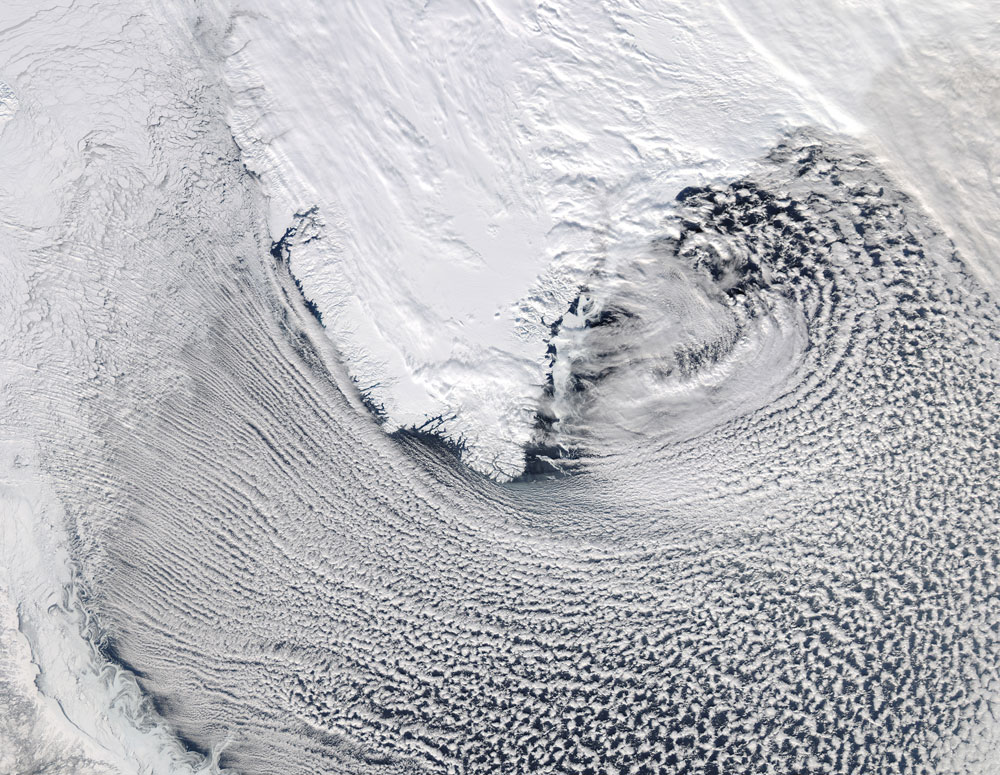
A mesmerizing pattern of clouds surrounding southern Greenland was spotted by a NASA satellite in orbit around Earth.
The agency's Aqua satellite snapped this stunning image of cloud streetsaround Greenland's southern tip on March 6.
Cloud streets are bands of cumulus clouds that form parallel to the low-level wind direction when conditions are right, scientists from NASA's Goddard Space Flight Center in Greenbelt, Md. said in a statement.
Article continues belowThese clouds form by convection, which is the process in which lower density warm air rises as cold air sinks. As the sun shines and heats the moist air at ground level, it begins to rise. As this air rises, it begins to cool. When it reaches a certain temperature, the water in the air condenses onto tiny particles that are suspended in the atmosphere to form clouds.
Cloud streets form in the lowest part of the atmosphere, called the planetary boundary layer. These long rolls of air develop roughly parallel with the ground and can form over water or land.
This natural phenomenon creates fascinating views from below, but when these cloud patterns stretch across hundreds of kilometers, the spectacle is more dramatic as seen from above, NASA scientists said.
This true-color image was captured by the Moderate Resolution Imaging Spectroradiometer instrument aboard NASA's Earth-watching Aqua satellite.
Get the world’s most fascinating discoveries delivered straight to your inbox.
Aqua flies roughly 438 miles (705 kilometers) above sea level, and is designed to collect a variety of observations and images of the planet from this orbital perch. The satellite's MODIS instrument scans the entire surface of the planet every one to two days, providing scientists with data on global processes on land, in the oceans and in the lower atmosphere.
Aqua was launched on May 4, 2002, and carries six onboard instruments that constantly monitor Earth's water cycle, including evaporation from oceans, clouds, water vapor in the atmosphere, precipitation, sea ice and snow cover.
Follow OurAmazingPlanet for the latest in Earth science and exploration news on Twitter @OAPlanet and on Facebook.
 Live Science Plus


