Tropical Cyclone Giovanna has left its mark on Madagascar and is now moving toward mainland Africa, as a new NASA satellite image shows.
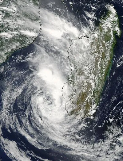
Giovanna crossed over the island of Madagascar on Feb. 13 where it caused flooding and severe damage. The storm has now entered the Mozambique Channel. NASA's Aqua satellite captured an image that showed a ragged eye still exists, and the storm is regaining strength in the warm channel waters.
The storm was at one time as strong as a Category 4 hurricane. In the Atlantic basin, tropical cyclones are called tropical storms and hurricanes depending on their strength.
Latest Videos From
Once Giovanna hit Madagascar and entered the Mozambique Channel, the body of water between Madagascar and Mozambique on the African mainland, NASA's Aqua satellite passed overhead and captured a visible image with the Moderate Resolution Imaging Spectroradiometer (MODIS) instrument.
MODIS captured the image at 5:45 a.m. EST on Feb. 15. The image shows that convection (rising air that forms the thunderstorms that make up the storm) had diminished greatly in the northwestern quadrant of the storm. The MODIS image also showed that thunderstorms were now building around the rest of the tropical storm as a result of moving into the warm waters of the Mozambique Channel. Warm sea surface temperatures of at least 80 degrees Fahrenheit (26.6 degrees Celsius) are needed to maintain a tropical cyclone, and temperatures in the channel are as warm as 88 F (31 C).
On Feb. 15, Giovanna's maximum sustained winds were near 46 mph (74 kph) and the storm's center was some 250 nautical miles west-southwest of Antananarivo, Madagascar. The storm is moving to the west-southwest at 15 mph (24 kph).
At least two people died during the storm, and the town Vatomandry, south of where Giovanna made landfall in east-central Madagascar, has experienced a lot of damage, according to news reports. Trees, phone and power lines have been downed, especially in eastern areas, as recovery efforts continue.
The Joint Typhoon Warning Center uses satellite data and forecast computer models to create forecasts. The current forecast for Giovanna now takes it on a westerly track toward Mozambique by the week's end. The forecast also indicates that wind shear will increase, which will prevent the storm from strengthening further. Residents along the southeastern coast of Mozambique should monitor the path of this tropical storm, according to the warning center.
Follow OurAmazingPlanet for the latest in Earth science and exploration news on Twitter @OAPlanet and on Facebook.