El Niño is ending and it's colder cousin La Niña is set to start, NASA observations indicate.
A La Niña is essentially the opposite of an El Niño. During a La Niña, trade winds in the western equatorial Pacific are stronger than normal, and the cold water that normally exists along the coast of South America extends to the central equatorial Pacific.
La Niñas change global weather patterns and are associated with less moisture in the air, resulting in less rain along the coasts of North and South America. They also tend to increase the formation of tropical storms in the Atlantic.
Latest Videos From
"For the American Southwest, La Niñas usually bring a dry winter, not good news for a region that has experienced normal rain and snowpack only once in the past five winters," said Bill Patzert, an oceanographer and climatologist at NASA's Jet Propulsion Laboratory in Pasadena, Calif.
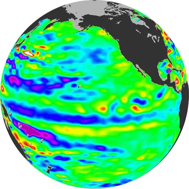
The latest image of Pacific Ocean sea surface heights from the NASA/European Ocean Surface Topography Mission/Jason-2 oceanography satellite, dated June 11, 2010, shows that the tropical Pacific has switched from warm to cold during the last few months.
In the image, the blue area in the center of the image depicts the recent appearance of cold water hugging the equator, which the satellite measures as a region of lower-than-normal sea level.
Remnants of the El Niño warm water pool still linger north and south of the equator, the observations show.
The satellite image showed that sea surface heights were about 4 inches (10 cm) above normal in warmer regions (these appear red in the image), while the regions where cooler water prevails are 6 to 7 inches (14 to 18 cm) below normal (these appear purple).
Sea surface heights are influenced by ocean temperatures and winds, and so in turn reflect the overarching conditions of ocean regions, including patterns like El Niño and La Niña.
Changes in the ocean impact the atmosphere and climate patterns around the globe. In turn, changes in the atmosphere impact the ocean temperatures and currents. This system oscillates between warm (El Niño) to neutral (or cold La Niña) conditions on average every three to four years. La Niña conditions typically last around nine to 12 months, according to the National Oceanic and Atmospheric Administration (NOAA), though some can persist for as long as two years.
"The central equatorial Pacific Ocean could stay colder than normal into summer and beyond. That's because sea level is already about 4 inches (10 cm) below normal, creating a significant deficit of the heat stored in the upper ocean," Patzert said. "The next few months will reveal if the current cooling trend will eventually evolve into a long-lasting La Niña situation."

 Live Science Plus