It's quick and easy to access Live Science Plus, simply enter your email below. We'll send you a confirmation and sign you up for our daily newsletter, keeping you up to date with the latest science news.
A powerful 8.2-magnitude earthquake that rocked Chile Tuesday night (April 1) originated in a seismic hotspot that has produced some of the world's strongest tremors in history.
Given the size and strength of the jolt, the current death toll of six seems rather modest. The tsunami it generated was relatively localized, too. One of the worst-hit areas, Iquique, a port city in northern Chile, about 60 miles (96 kilometers) from the earthquake's epicenter, was hit by a tsunami wave of nearly 7 feet (2.1 meters). For comparison, the 9.0-magnitude earthquake that struck Japan in March 2011 caused a massive tsunami wave that reached heights of up to 133 feet (40.5 m).
Even when they don't cause widespread damage, tsunami waves can travel far. Through a network of sensors at the bottom of the ocean and sophisticated computer models, scientists can measure the ripples of these huge waves thousands of miles from their origin. [The 10 Biggest Earthquakes in History]
Tuesday's earthquake occurred along a so-called subduction zone, where one tectonic plate plows beneath another. Off the Pacific coast of South America, the Nazca Plate is squeezing under the South America plate.
While some earthquakes originate from side-to-side sliding along a crack like the San Andreas Fault in California, subduction zone tremors are associated with vertical plate movement. And when one plate sinks, water is displaced and a deep ocean wave is generated, said Michael Angove, the National Oceanic and Atmospheric Administration's (NOAA) tsunami program manager.
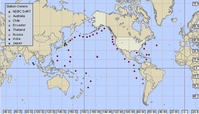
Each DART sensor on the seafloor measures water column pressure to track the size of potential tsunami waves.
(Image credit: NOAA)
What sets a tsunami apart from others waves is the way it hits the bottom of the ocean, Angove said.
Sign up for the Live Science daily newsletter now
Get the world’s most fascinating discoveries delivered straight to your inbox.
"Its wavelength goes through the whole length of the ocean," Angove told Live Science.
To track these big waves, NOAA manages a network of 39 sensors anchored to the seafloor at a depth of 13,000 feet to nearly 20,00 feet (4,000 to 6,000 meters). These devices are linked to a surface platform that acts as a receiver and transmitter, beaming data to satellites overhead.
These so-called DART stations (short for deep-ocean assessment and reporting of tsunami) line the Pacific "Ring of Fire," where most of the world's earthquakes and volcanic eruptions occur. While most sensors in this network are operated by the United States, other countries — including Australia, Ecuador, Japan and Russia — have contributed their own stations.
In the last two years, the Chilean government added two of its own stations off the country's northern coast, Angove said, and this is the first seismic event in which those new trackers were really put to use.
Effects of the tsunami
The earthquake that shook Chile Tuesday didn't produce enough energy to trigger a severely threatening tsunami outside of the Pacific coast of South America, Angove said. Nonetheless, a tsunami advisory was in place for Hawaii, where strong currents could pose risks for swimmers, boaters and surfers.
"In Hawaii, oftentimes we'll see surfers who think this is like Christmas," said Susan Buchanan, a NOAA spokeswoman. "They often underestimate the power of the current, but it's very dangerous for them to be the water."
Indeed, Angove noted that the currents could be as strong as 3 to 4 knots.
But for a truly damaging tsunami originating from Chile to hit Hawaii and the western coast of the United States, the earthquake might have to be at least 8.5 in magnitude, Angove said.
That's not to say that an earthquake of smaller magnitude couldn't produce a devastating tsunami. There are earthquakes that scientists call "tsunami earthquakes" that shake out much more slowly than a normal earthquake. They tend to occur in the shallowest portion of a subduction zone, and they produce waves much bigger than their magnitude would suggest, said Georgia Institute of Technology earthquake researcher Andrew Newman.
"Tsunami earthquakes are a third as fast — they take three times as long to rupture," Newman told Live Science. "They still do just as good of a job at moving that mass that's creating the tsunami wave."
Megan has been writing for Live Science and Space.com since 2012. Her interests range from archaeology to space exploration, and she has a bachelor's degree in English and art history from New York University. Megan spent two years as a reporter on the national desk at NewsCore. She has watched dinosaur auctions, witnessed rocket launches, licked ancient pottery sherds in Cyprus and flown in zero gravity. Follow her on Twitter and Google+.