
Sandy to Take Aim at New England, Mid-Atlantic
This article was provided by AccuWeather.com.
Sandy, currently a Category 2 hurricane near the Bahamas, is forecast to take a turn toward the Atlantic Coast and make landfall early next week between Virginia and Nova Scotia.
Article continues belowRELATED:
AccuWeather.com Hurricane Center
Remembering "The Perfect Storm" of 1991
Sandy's Eye Plows Across Jamaica, Cuba
Will the Elections be Impacted by the Storm?
While the dangerous storm is still days away, the probability of the feared left hook has increased and will take place during a big atmospheric fight from the mid-Atlantic to New England and neighboring Canada. The result could be a knockout blow to some areas and not only along the immediate coast.
Tens of millions of people and thousands of communities could be impacted by the storm.
Exactly where this change of direction takes place is critical for the worst impacts, which have the potential to be very disruptive, if not very damaging and in some cases life-threatening. Odds are a few major metropolitan areas within the swath from Norfolk, Va., to New York City to Bangor, Maine, will be hit the hardest.
Impacts
Some areas will be hit with damaging winds, power outages, flooding rainfall, battering surf and storm surge. Windswept rain will slow travel in general. Some roads may be blocked by high water and downed trees. Air travel disruptions could radiate outward from the epicenter.
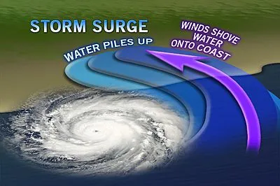
Anywhere near the storm center to 100 miles or more to the northeast of the center during landfall, there is an elevated risk of coastal flooding due to storm surge.
The storm will be making landfall around the same date as the full moon, a time when higher tides occur relative to the balance of the month. There is the potential for a storm surge of five feet or more in some areas, depending on point of landfall and shape of the local coastline.
Trees and power lines will come down. The strongest winds would also occur near and northeast of the storm center to within a few hours during landfall. Gusts to hurricane force (74 mph) are possible. However, gusts (40 to 60 mph) can occur for a time around much of the storm's circulation out to at least 100 miles and perhaps more.

Drenching rain and the greatest risk of flash and urban flooding would occur to the west, northwest and north of the center moving inland from the Atlantic. Some areas could receive a half a foot of rain. The Appalachians would enhance the risk of flash and small stream flooding. Fallen leaves causing blocked storm drains will increase the risk of urban flooding.
AccuWeather.com meteorologists feel that as long as heavy rain does not linger for more than a day or two most major rivers will handle the runoff without major flooding. Rivers are generally at a very low state during this point in the season. However, some rises on these rivers are to be expected. The rain could be more of a beneficial aspect in some areas, say in abnormally dry portions of northern and western New York state.
South and southwest of where the storm makes landfall, away from the center of the storm, the effects would be much less dramatic. A sweep of dry air typically occurs in this zone. However, it can get very windy for a time, until the storm strength diminishes.
Well west of the center of the storm snow could fall, even past the peak of the mayhem farther east. This is possible over portions of the Great Lakes and perhaps into the high ground of the central Appalachians.
Caution Against Dismissing This Storm
While there is the potential for Sandy to be declassified as a non-tropical storm upon entering the cooler waters of the North Atlantic, prior to landfall, it is hardly likely to be a weakening storm.
According to Expert Senior Meteorologist Dan Kottlowski, head of AccuWeather.com's Hurricane Center, "We are concerned that some people may dismiss the storm because of a downgrade or an initial path well out to sea. The sudden left turn and strength of the system may catch some people off guard."
According to AccuWeather.com Chief Meteorologist Elliot Abrams, "The details of exactly where landfall occurs will not be apparent perhaps until the left turn actually begins this weekend. However, the zone likely to experience the most damaging and disruptive effects will be narrowed down as more information become available."
The opportunity to protect property will end quickly in this situation. If you want to take precautionary measures, waiting until Sunday evening to do so may be too late. Don't put yourself in harm's way during the storm later Sunday into Tuesday.
AccuWeather.com. All rights reserved. More from AccuWeather.com.
The only sure thing about weather forecasts is that they’re wildly different all over the planet. Test your knowledge on the wild ranges in temperature, precipitation and more.
Extreme Weather Facts: Quiz Yourself
