Stunning 'sunglint' turns the sea's surface into a swirling silver mirror
An astronaut captured the breathtaking scene from the International Space Station.

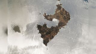
An astronaut on the International Space Station (ISS) recently snapped a stunning photograph of a "sunglint" that transformed the sea’s surface into a swirling, silver mirror surrounding a pair of Greek islands. The color-changing phenomenon, caused by the sun's light reflecting off the still sea directly into the astronaut's camera, highlights interesting oceanographic effects on and below the water’s surface.
An unidentified member of the Expedition 67 crew captured the image on June 25 using a digital camera pointed out of an ISS window. The larger landmass at the heart of the photo is Milos, a 58 square-mile (151 square kilometers) Greek volcanic island, and its diminutive, uninhabited partner to the west is Antimilos, which is around 3 square miles (8 square km) in size. The silvery seas surrounding the islands are the Myrtoan Sea to the northwest of Milos and the Sea of Crete to the southwest, both of which are part of the larger Mediterranean Sea. The image was released online Sept. 12 by NASA's Earth Observatory.
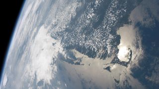
Sunglints can be seen by observers in space as sunlight reflects off particularly calm seas, or other flat bodies of water with little to no wave action. It is similar to how the light reflects off a still sea during a sunrise or sunset when viewed from Earth, which causes a shiny streak across the surface; but from space, the streak looks like a massive silvery patch, often covering several hundred square miles, and appears to move across the ocean as Earth rotates.
The wavy lines and swirls in the image, which cut across the sea's silver surface like scratches on a mirror, are caused by wind-driven surface currents and deeper sea currents below the surface, as well as rarer phenomena, such as internal waves moving below the water’s surface, and gyres — large systems of rotating ocean currents. Most of these features would normally go unnoticed from space, but because they scatter some of the sun's light, the features become glaringly obvious during a sunglint.
Related: Landsat satellites: 12 amazing images of Earth from space
One of the most striking oceanographic features in the image is a vortex-like gyre located to the east of Milos, which looks almost like an enormous whirlpool from above. However, rather than pulling stuff down like a whirlpool, these patches of swirling water play an important role in sustaining nearby currents that cycle nutrients through the ocean, according to the National Oceanic and Atmospheric Administration (NOAA).
Another noteworthy feature is the long, straight line in the bottom left of the picture, which is most likely the wake from a ship that was moving at speed across the surface, according to NASA's Earth Observatory.
Sign up for the Live Science daily newsletter now
Get the world’s most fascinating discoveries delivered straight to your inbox.
But the most interesting feature in the photo is arguably the rather innocuous-looking set of parallel lines off the northeast coast of Antimilos. These lines, which are mostly obscured by the cloud surrounding the island, are "internal waves" — massive vertical waves that pass through the water beneath the surface. Unlike surface waves, which are mainly driven by ocean currents or strong winds, internal waves are the result of gravity waves (not to be confused with gravitational waves in space-time).
Gravity waves pass across the interface, or meeting points, of two fluid mediums after gravity disrupts the equilibrium between the two, which in this case is caused by Earth's tides. The seas are stratified, meaning they are made up of layers of water with different densities due to variations in temperature and salinity. Gravity waves can, therefore, form where these layers meet, creating internal waves within the ocean, according to The Conversation.

Normally, internal waves pass through the water without a visible trace. But sunglints provide the necessary contrast to illuminate the hidden waves beneath the surface. Other sunglint images captured by astronauts and satellites can also highlight atmospheric gravity waves that occasionally form where the atmosphere and ocean surface meet, creating massive ripples. As a result, scientists commonly use sunglints to study gravity waves above and below the surface, according to The Conversation.
Researchers also use images of sunglints to track oil spills, because oil slicks on the surface of the ocean reflect less light than water, according to NOAA.
However, for other marine scientists who depend on satellite images to track algal blooms or monitor the color of the ocean, sunglints can be a nuisance. As a result, these scientists often have to edit out the sunglints from their satellite images, according to NOAA.
Originally published on Live Science.

Harry is a U.K.-based senior staff writer at Live Science. He studied marine biology at the University of Exeter before training to become a journalist. He covers a wide range of topics including space exploration, planetary science, space weather, climate change, animal behavior, evolution and paleontology. His feature on the upcoming solar maximum was shortlisted in the "top scoop" category at the National Council for the Training of Journalists (NCTJ) Awards for Excellence in 2023.
