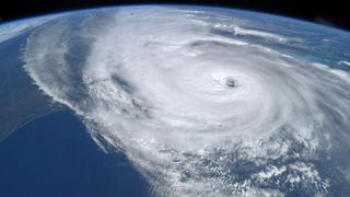
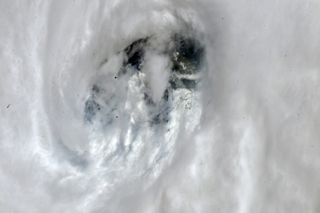
Peer into Hurricane Ian’s 'eye' in this photo that an astronaut snapped from space
'Reintensification' is likely as Ian churns toward the Carolinas on Friday, forecasters warn.

Astronauts watched from orbit as powerful Hurricane Ian slammed into Florida on Wednesday (Sept. 28).
Expedition 68 astronaut Bob Hines of NASA captured footage of the weakening, yet still forceful, hurricane from the International Space Station (ISS).
"This storm is HUGE! That’s the Mississippi River and New Orleans on the left. It covers the entire Florida peninsula! We could see through the eye just as it was making landfall. Praying for the safety of everyone dealing with #HurricaneIan," Hines tweeted Wednesday.
Hurricane Ian weakened to a tropical storm as it crossed Florida on Thursday (Sept. 29). But it still brought strong winds and heavy winds to the Space Coast, forcing the delay of several launches. For example, earlier this week, NASA pulled its Artemis 1 moon rocket off Launch Pad 39B at NASA's Kennedy Space Center (KSC) to shelter at the cavernous Vehicle Assembly Building. NASA had been targeting a Sept. 27 launch for the mission.
KSC is closed for normal operations while a small "rideout crew" remains to help keep the center safe through the storm.
Related: 'Extremely dangerous' Hurricane Ian makes landfall in Florida (video)

NASA and SpaceX also postponed the company's Crew-5 astronaut mission to Oct. 5, at least two days past its original scheduled launch opportunity on Oct. 3. SpaceX and United Launch Alliance also chose to push other planned Space Coast launches from Friday (Sept. 30) into next week at the earliest.
Sign up for the Live Science daily newsletter now
Get the world’s most fascinating discoveries delivered straight to your inbox.
Ian was classified as a Category 4 hurricane when it hit southwest Florida on Wednesday (Sept. 28), but it later weakened to a tropical storm. The ISS forms part of a network of observations tracking the storm in real time from orbit, although forecasts rely upon a set of satellites managed by NASA and the U.S. National Oceanic and Atmospheric Administration (NOAA), among other entities.
This storm is HUGE! That’s the Mississippi River and New Orleans on the left. It covers the entire Florida peninsula! We could see through the eye just as it was making landfall. Praying for the safety of everyone dealing with #HurricaneIan. 🙏 pic.twitter.com/sZZE9gugeaSeptember 28, 2022
NOAA's advisory at 8 a.m. EDT (1200 GMT) on Thursday (Sept. 29) includes numerous warnings of life-threatening flooding, storm surges, and winds, stretching across Florida, Georgia, and the Carolinas.
"The center of Ian is expected to move off the east-central coast of Florida soon and then approach the coast of South Carolina on Friday. The center will move farther inland across the Carolinas Friday night and Saturday," NOAA officials said in the forecast.
"Maximum sustained winds remain near 65 mph (100 km/h) with higher gusts," the agency added, but warned "reintensification" may occur as the hurricane approaches the coast of South Carolina Friday. "Weakening is expected Friday night and Saturday after Ian moves inland," NOAA officials said.
Daytona Beach International Airport, just an hour north of KSC, recently reported sustained winds of 60 mph (97 km/h) and a gust to 70 mph (113 km/h), NOAA said.
Originally published on Space.com.


