Earth Has Its Picture Taken on 12/12/12
Get the world’s most fascinating discoveries delivered straight to your inbox.
You are now subscribed
Your newsletter sign-up was successful
Want to add more newsletters?
Delivered Daily
Daily Newsletter
Sign up for the latest discoveries, groundbreaking research and fascinating breakthroughs that impact you and the wider world direct to your inbox.
Once a week
Life's Little Mysteries
Feed your curiosity with an exclusive mystery every week, solved with science and delivered direct to your inbox before it's seen anywhere else.
Once a week
How It Works
Sign up to our free science & technology newsletter for your weekly fix of fascinating articles, quick quizzes, amazing images, and more
Delivered daily
Space.com Newsletter
Breaking space news, the latest updates on rocket launches, skywatching events and more!
Once a month
Watch This Space
Sign up to our monthly entertainment newsletter to keep up with all our coverage of the latest sci-fi and space movies, tv shows, games and books.
Once a week
Night Sky This Week
Discover this week's must-see night sky events, moon phases, and stunning astrophotos. Sign up for our skywatching newsletter and explore the universe with us!
Join the club
Get full access to premium articles, exclusive features and a growing list of member rewards.
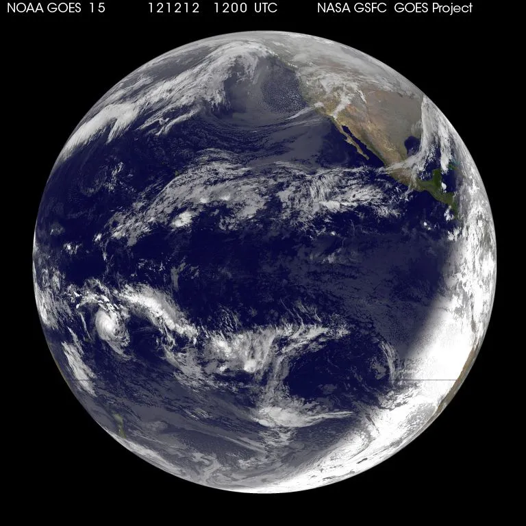
As you probably know, today is 12/12/12, the last time a date in this particular structure will have all three numbers the same until the year 2112.
On this auspicious date (or perfectly ordinary date, depending on how into numerology you are), the National Oceanic and Atmospheric Administration's (NOAA) GOES-15 snapped an image of Earth at 1200 UTC (7:00 a.m. ET).
Visible in the image is system that would soon become Tropical Storm Evan, which formed over the Pacific Ocean earlier today, according to a NOAA statement. It is the swirl-like area of clouds at the bottom left of the Earth's disk. The storm is currently 145 nautical miles (233 kilometers) west of Pago Pago, the capital of American Samoa.
Another satellite, the Suomi NPP, recently got another set of stunning images of our home planet, which are being called the "Black Marble" because they are all nighttime views of the Earth. There is even a zoomable Gigapan image of the Black Marble set, where viewers can focus in on different parts of the globe and see the Earth's lights at night.
The Black Marble appellation is a play on the famous "Blue Marble" image of the Earth taken by the Apollo 17 astronauts and thought to be one of the most famous and widely distributed images of Earth ever.
This story was provided by OurAmazingPlanet, a sister site to LiveScience.
Get the world’s most fascinating discoveries delivered straight to your inbox.

Andrea Thompson is an associate editor at Scientific American, where she covers sustainability, energy and the environment. Prior to that, she was a senior writer covering climate science at Climate Central and a reporter and editor at Live Science, where she primarily covered Earth science and the environment. She holds a graduate degree in science health and environmental reporting from New York University, as well as a bachelor of science and and masters of science in atmospheric chemistry from the Georgia Institute of Technology.