While Hurricane Isaac bore down on the Gulf Coast last night (Aug. 28), another storm was born out in the Atlantic: Tropical Storm Kirk.
Kirk is the 11th named storm of the 2012 Atlantic hurricane season. It currently has maximum sustained winds of 45 mph (75 kph) and is 1,135 miles (1,825 kilometers) east-northeast of the northern Leeward Islands according to the latest update from the National Hurricane Center (NHC).
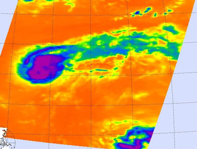
Infrared instruments on NASA's Aqua satellite imaged Kirk at 12:29 a.m. EDT today, revealing powerful thunderstorms around the center of circulation that indicate the storm is continuing to strengthen.
Latest Videos From
Cloud top temperatures were colder than minus 63 degrees Fahrenheit (minus 52 degrees Celsius) around the center of circulation and west of the center. That's where the strongest storms and heaviest rainfall were occurring, according to a NASA statement.
Wind shear — when winds at different levels of the atmosphere are moving in different directions — have been affecting Kirk from the southwest. Those winds were pushing clouds and showers associated with Kirk to the northeast giving Kirk the appearance of a "comet tail" in infrared imagery, NASA said.
Wind shear can hamper a storm's development, and in Kirk's case, that and dry air will slow its intensification.
Kirk is expected to become a hurricane over the weekend, but will remain far out at sea and won't be a threat to land. It would be the fifth hurricane of the 2012 season.
Meanwhile, NHC forecasters are keeping their eye on a low pressure system about 900 miles west of the Cape Verde Islands that they give a 60 percent chance of developing into a tropical cyclone. If it becomes one, it will be named Leslie.
Leslie would be the 12th named storm of the 2012 Atlantic hurricane season, which the National Oceanic and Atmospheric Administration has said will likely have between 12 and 17 named storms, of which forecasters expect give to eight will become hurricanes.
This story was provided by OurAmazingPlanet, a sister site to LiveScience.

 Live Science Plus