A windstorm that swept across Kansas, Missouri and Illinois in May 2009 was so fierce that it has earned a brand-new name: super derecho.
A derecho (from the Spanish adverb for "straight") is a long-lived windstorm that forms in a straight line — unlike the swirling winds of a tornado — and is associated with what's known as a bow echo, a line of severe thunderstorms. The term "derecho" was first used over a century ago to describe a storm in Iowa. Across the United States there are generally one to three derecho events each year.
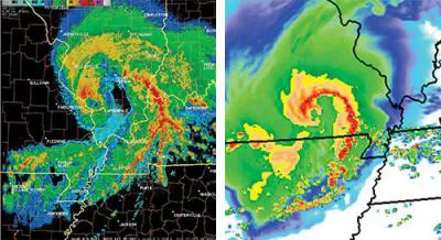
The May 8, 2009, derecho, however, was in a league of its own. An intense vortex and eye-like structure similar to what forms at the center of tropical cyclones (the generic name for tropical storms and hurricanes) appeared in the bow echo, said study team member Clark Evans of the National Center for Atmospheric Research, in Boulder, Colo.
Latest Videos From
The storm gained strength as it moved across Kansas in the early morning, spinning off 18 tornadoes and packing wind speeds from 70 to 90 mph (115 to 145 kph) when it hit Springfield, Mo. The super derecho plowed a path of destruction through the state about 100 miles (62 kilometers) wide, crossed the Mississippi River with 90 to 100 mph (145 to 160 kph) wind gusts and blew through Illinois before dissipating at that state's eastern border.
Twenty-four hours in advance, scientists were able to predict what the storm would look like, producing the highest-resolution, most accurate real-time forecast to date of such an event. The data from the forecast are now helping storm-studying scientists understand how and why the derecho became so intense.
"We are currently in the process of determining how the super derecho developed and evolved, seeking to understand how and why it became so strong as compared to other derecho events," Evans said. "We also want to know how and why the eye-like structure and associated intense area of low pressure developed, especially given the exceedingly rare nature of these features."
This article was provided by OurAmazingPlanet, a sister site to LiveScience.