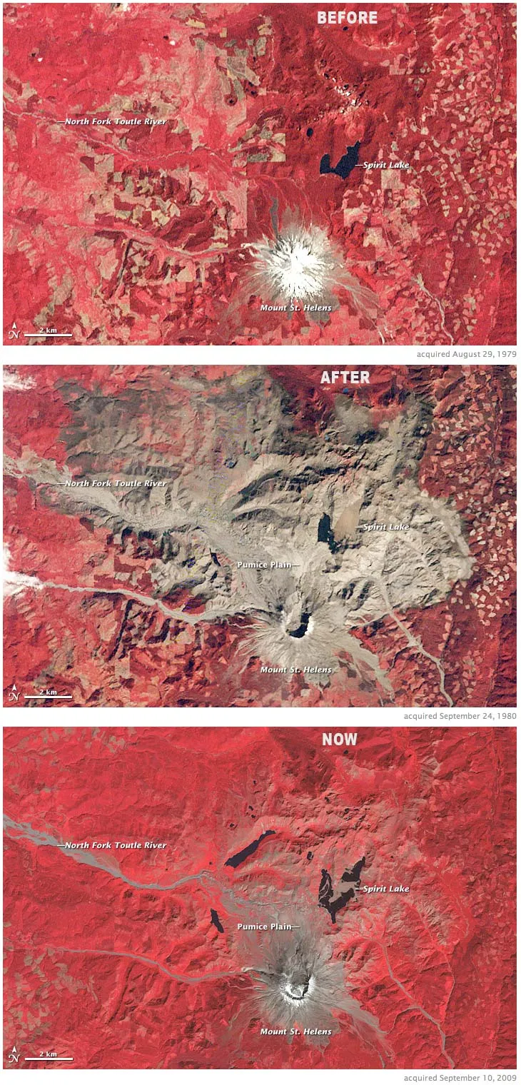
A newly released trio of false-color images from NASA's Landsat satellite documents the destruction and recovery at Mount St. Helens. Vegetation is red, bare rock and volcanic debris are gray, and clear water is dark blue.
A newly released trio of false-color images from NASA's Landsat satellite documents the destruction and recovery at Mount St. Helens. Vegetation is red, bare rock and volcanic debris are gray, and clear water is dark blue. In the middle image, a huge gray scare reveals the destruction caused by the huge volcanic eruption May 18, 1980. More about the image below.
The 1979 view (top) shows the snow-covered summit of the perfectly shaped stratovolcano, and the mixture of protected forest (darkest red, north of the volcano), agricultural land (lighter reds), and logging clear cuts (patchwork of squares at image right) that surrounded the mountain, researchers at NASA's Earth Observatory explained.
The image from Sept. 24, 1980 (middle), shows the devastation of the eruption. The northern flank of the mountain collapsed, producing the largest landslide in recorded history. The avalanche buried 14 miles (23 kilometers) of the North Fork Toutle River with an average of 150 feet (46 meters) — but in places up to 600 feet (180 meters) — of rocks, dirt, and trees. The blast spread rock and ash (gray in the images) over 230 square miles (600 square kilometers). A raft of dead trees floats across Spirit Lake. Volcanic mudflows (lahars) poured down rivers and gullies around the intact flanks.
Three decades later, the bottom image (from Sept. 10, 2009) shows the recovery in the blast zone. Most of the landscape within the blast zone has at least a tinge of red, meaning vegetation has recolonized the ground. The flanks of the volcano itself are still bare, as is a broad expanse north of the volcano called the Pumice Plain.
Directly in the path of the landslide and several pyroclastic flows, this area has been slowest to recover. Ground surveys, however, have found even this seemingly barren area is coming back to life: the first plant to re-appear was a prairie lupine, which can take nitrogen—a critical plant nutrient—straight from the air rather than from the soil. These small wildflowers begin the crucial task of rebuilding the soil and attracting insects and herbivores. This process is underway on the Pumice Plain, even though it is not yet visible from space, scientists said.
Gallery: The Incredible Eruption of Mount St. Helens
For the science geek in everyone, Live Science offers a fascinating window into the natural and technological world, delivering comprehensive and compelling news and analysis on everything from dinosaur discoveries, archaeological finds and amazing animals to health, innovation and wearable technology. We aim to empower and inspire our readers with the tools needed to understand the world and appreciate its everyday awe.