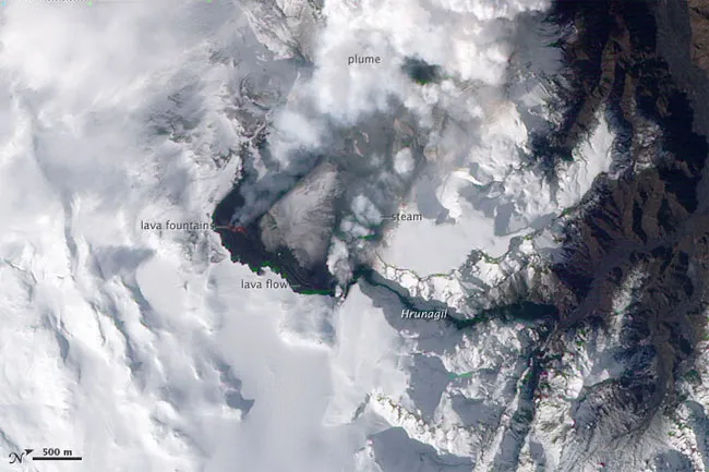
A new satellite image reveals in natural color the lava fountains and flows, along with other features
Iceland's Eyjafjallajökull Volcano burst into life for the first time in 190 years on March 20, 2010. Now a new image taken from space reveals the resulting lava fountains and flows, along with steam from vaporized snow.
The Eyjafjallajokull (AYA-feeyapla-yurkul) volcano is part of the volcanic complex that originally formed Iceland. While the eruption was not been a major one, it did cause residents in the surrounding areas to evacuate.
Latest Videos From
Acquired on March 24, 2010, by the Advanced Land Imager (ALI) aboard NASA's Earth Observing-1 satellite, the new image reveals orange-red lava fountains, barely visible at the 33-foot (10-meter) resolution of the satellite. The fountains quickly built several hills of bubble-filled lava rocks called scoria, which surround the fissure and are black, as is the lava flow extending to the northeast.
The image also shows white volcanic gases that escaped from both the vent and erupting lava, along with a steam plume ising where the hot lava meets snow.
The eruption of Eyjafjallajökull was presaged by a series of earthquakes starting in early March. Over time, the earthquakes rose toward the surface, and land near the volcano rose at least 2 inches (40 millimeters) — both indications that magma was moving underneath the volcano. The eruption continued through at least March 26, and could continue for several more months.
Previous eruptions in the area have caused flooding due to the melting of glacial ice (called a Jökulhlaup), but the current eruption is in an area covered by winter snow, not permanent ice. Although some past eruptions of Eyjafjallajökull were followed by larger, explosive eruptions at nearby Katla Volcano, there is currently no sign of activity at Katla.