Satellite Spies Flooding After Levee Blast
Get the world’s most fascinating discoveries delivered straight to your inbox.
You are now subscribed
Your newsletter sign-up was successful
Want to add more newsletters?
Delivered Daily
Daily Newsletter
Sign up for the latest discoveries, groundbreaking research and fascinating breakthroughs that impact you and the wider world direct to your inbox.
Once a week
Life's Little Mysteries
Feed your curiosity with an exclusive mystery every week, solved with science and delivered direct to your inbox before it's seen anywhere else.
Once a week
How It Works
Sign up to our free science & technology newsletter for your weekly fix of fascinating articles, quick quizzes, amazing images, and more
Delivered daily
Space.com Newsletter
Breaking space news, the latest updates on rocket launches, skywatching events and more!
Once a month
Watch This Space
Sign up to our monthly entertainment newsletter to keep up with all our coverage of the latest sci-fi and space movies, tv shows, games and books.
Once a week
Night Sky This Week
Discover this week's must-see night sky events, moon phases, and stunning astrophotos. Sign up for our skywatching newsletter and explore the universe with us!
Join the club
Get full access to premium articles, exclusive features and a growing list of member rewards.
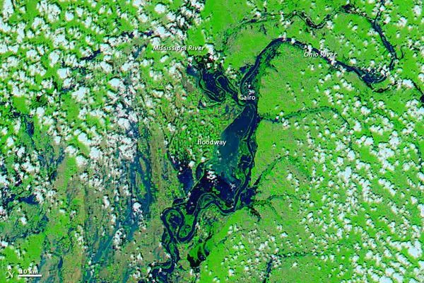
Late on May 2, 2011, in an effort to spare Cairo, Illinois, the U.S. Army Corps of Engineers used explosives to breach a protective levee near the confluence of the Ohio and Mississippi Rivers, according to a NASA statement. As predicted, the two-mile hole in the levee flooded 130,000 acres of nearby farmland in what is known as the Birds Point-New Madrid Floodway.
The Moderate Resolution Imaging Spectroradiometer (MODIS) on NASA's Aqua satellite captured these images of the area on May 3, 2011 (top), and April 29, 2011 (bottom). Both images use a combination of visible and infrared light to increase constrast between water and land. Water ranges in color from electric blue to navy. Vegetation is green. Clouds are pale blue-green and cast shadows onto the land surface below.
Tiny squares of green in the April 29 image show that the floodway consists of farmland. The image from April 29 also shows flooded conditions along the Ohio and Mississippi Rivers. In the image acquired on May 3, the floodway downstream of Cairo is submerged. The same day that MODIS acquired the image, the Advanced Hydrological Prediction Service of the U.S. National Weather Service reported that the water level for the Ohio River at Cairo had dropped, although it still remained at major flood stage.
Get the world’s most fascinating discoveries delivered straight to your inbox.

