


Snowstorm to Hit New England Again on the Weekend
This article was provided by AccuWeather.com.
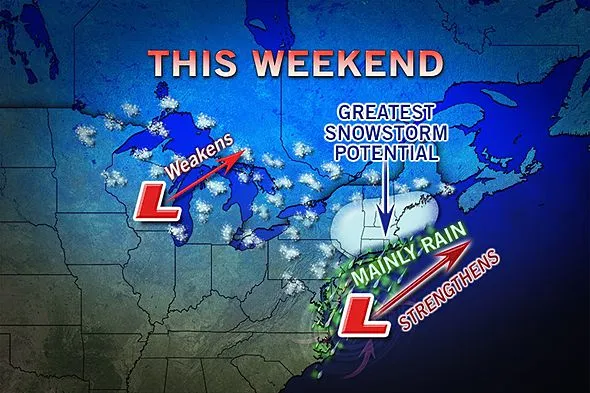
A storm bringing up to a couple of feet of snow over the Plains will reorganize on the East Coast this weekend and will deliver heavy snow to part of New England by Sunday.
It will be the third weekend in a row that a snowstorm will impact parts of the region.

Heavy snow is also a possibility from northern Connecticut and northwestern Rhode Island to southern Maine. Boston has a chance at breaking a February snowfall record with this storm. So far 32.0 inches of snow has fallen this month. The February record is 41.6 inches.
Other cities that have the potential for 6 inches of snow or more include Worcester, Mass., Portsmouth, N.H., and Portland, Maine.
Marginal temperatures will cause the snow to be wet in much of southern and central New England. In these areas, the first part of the storm will be rain Saturday.
However, colder air will invade the storm while it strengthens near Cape Cod late Saturday night and Sunday. Snowfall accumulation rates could increase to 1-2 inches per hour in some locations, and road conditions will quickly turn from wet to slushy to snow-covered.
Get the world’s most fascinating discoveries delivered straight to your inbox.
As the storm strengthens later Saturday night into Sunday, winds will pick up in central and southeastern New England causing a plastering effect in some areas and blowing and drifting snow in colder locations.
RELATED: February 2013 Could Finish Snowiest on Record in Boston Big Snow from Kansas to Nebraska; Snow to Reach Chicago Storm Potential on East Coast Starting This Weekend: Omega Block
Accumulating snow is likely to extend westward into the Hudson Valley region of New York and northward into central portions of Vermont, New Hampshire and Maine. Some snow could reach as far southwest as the Poconos in northeastern Pennsylvania and as far north as northern Maine.
Odds favor mostly rain in New York City, Long Island and along the South Coast of New England Saturday with a wintry mix possible at the tail end Sunday. However, if the storm were to greatly strengthen, heavy accumulating snow could be pulled this far south.
The storm will bring primarily rain in the swath from Philadelphia to Washington, D.C., Friday night and Saturday. A few wet snowflakes could mix in at the tail end late Saturday night.
As we get to within 48 hours of the accumulating snow, AccuWeather.com will issue a snowfall prediction map.

Another storm aiming for the Plains late this weekend has the potential to bring coastal rain and inland snow to the mid-Atlantic Tuesday and New England Tuesday night into Wednesday. Details will follow in the coming days on AccuWeather.com.
This story was originally published at 10:00 a.m. EST, Thurs., Feb. 21, 2013.
© AccuWeather.com. All rights reserved. More from AccuWeather.com.
The only sure thing about weather forecasts is that they’re wildly different all over the planet. Test your knowledge on the wild ranges in temperature, precipitation and more.
Extreme Weather Facts: Quiz Yourself
