It's quick and easy to access Live Science Plus, simply enter your email below. We'll send you a confirmation and sign you up for our daily newsletter, keeping you up to date with the latest science news.
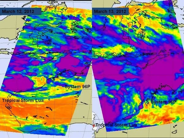
When NASA's Aqua satellite passed over northern Australia on March 12 at 1711 UTC and March 13 at 0539 UTC it captured two tropical disturbances close enough to appear on one image. Tropical Cyclone Lau in on the left side of the image and is in the Southern Indian Ocean, while System 96P is pictured right, and is in the Southern Pacific Ocean.
Two tropical storm systems are threatening Northern Australia today, and are so close to each other they were caught in the same satellite view.
One has gathered enough strength to be given an official name, Tropical Cyclone Lua, while the other is still getting organized and remains unnamed. The unnamed storm is currently the more immediate threat though, as it is close enough to the coast to warrant warnings of high seas.
NASA's Aqua satellite passed over the area at 0539 UTC yesterday (March 13) and was able to see both storms in a single image. Lua appears on the left in the image in the Southern Indian Ocean, with System 96P on the right, above the Southern Pacific Ocean.
Lua formed off the northern coast of Western Australia and as of yesterday it had maximum winds of about 40 mph (65 kph) and was located about 240 miles (386 kilometers) west-northwest of Port Hedland, Australia. (In the Atlantic basin, Lua would be a tropical storm.)
On March 13, 2012 at 0245 UTC, the MODIS instrument on NASA's Terra satellite captured this visible image of Tropical Cyclone Lua (17S) over Western Australia. The highest, strongest thunderstorms appear to be on the southern side of the circulation, as the higher storms are casting shadows on the lower surrounding clouds.
(Image credit: NASA Goddard MODIS Rapid Response Team)
Forecasters at the Joint Typhoon Warning Center (JTWC) expect the storm to meander for a couple of days before strengthening and then making landfall in the Pilbara region of Western Australia on March 16.
System 96P is located about 170 nautical miles west of Darwin and 115 nautical miles northwest of Port Keats and was moving to the south.
The Atmospheric Infrared Sounder (AIRS) instrument aboard the Aqua satellite showed that deep convection (rising air that forms the thunderstorms that make up the tropical cyclone) is growing in size around the circulation center. There are also bands of thunderstorms spiraling into the low's center.
Sign up for the Live Science daily newsletter now
Get the world’s most fascinating discoveries delivered straight to your inbox.
Because the system is over an area of warm water, it is becoming more organized, the JTWC said. They anticipate that it will become a tropical depression before curving towards the southeast for a landfall south of Port Keats late on March 14, or early on March 15. Local residents are advised to monitor the storm and take caution.
This story was provided by OurAmazingPlanet, a sister site to LiveScience.
For the science geek in everyone, Live Science offers a fascinating window into the natural and technological world, delivering comprehensive and compelling news and analysis on everything from dinosaur discoveries, archaeological finds and amazing animals to health, innovation and wearable technology. We aim to empower and inspire our readers with the tools needed to understand the world and appreciate its everyday awe.