It's quick and easy to access Live Science Plus, simply enter your email below. We'll send you a confirmation and sign you up for our daily newsletter, keeping you up to date with the latest science news.
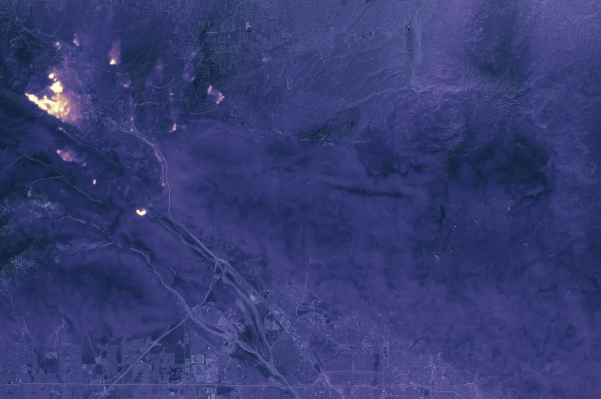
The Thermal Infrared Sensor (TIRS) on the Landsat 8 satellite captured this image of California's Blue Cut wildfire at 10:36 p.m. local time on Aug. 17, 2016.
The Blue Cut fire in California is hot. That heat allowed thermal sensors aboard the Landsat 8 satellite to capture a glowing image of the blaze at night.
The satellite image shows the active flames north of San Bernardino County, California, on Aug. 17, at 10:36 p.m. PDT (1:35 a.m. EDT). The fire continues to move north, northwest and northeast, according to the California Department of Forestry and Fire Protection (CalFire). [Earth from Above: 101 Stunning Images from Orbit]
The Blue Cut Fire started the morning of Aug. 16 in the Cajon Pass, west of Interstate 15; As of Aug. 18, the blaze had ballooned to about 35,969 acres, with 22 percent of that contained, according to CalFire.
The amount of damage from the erratic fire has been difficult to estimate, though authorities have said "numerous" buildings have been destroyed, according to the Los Angeles Times. No estimates have come out yet for the number of decimated homes, the LA Times reported.
The Blue Cut wildfire, seen in this Landsat 8 satellite image on Aug. 17, 2016, has forced tens of thousands of evaculations in San Bernardino County, California.
(Image credit: NASA Earth Observatory)
To create the newly released image, NASA overlaid the thermal data on a daytime image to show the fire's location, with warmer areas showing up as bright spots and cooler areas appearing dark, according to NASA's Earth Observatory.
Landsat 8 isn't the only satellite keeping its eye on California's fires. On Aug. 17, at 11:50 a.m. local time, NASA's Terra satellite got a glimpse of the fire's smoke plumes rising and spreading across the skies. The satellite's Multi-angle Imaging SpectroRadiometer (MISR) captured the fire in natural colors. A day earlier, on Aug. 16, just 3 hours after the fire was first reported, NASA's Aqua satellite provided a view showing smoke rising north of San Bernardino County.
Fires like this one could become more frequent with climate change, according to research. For instance, a study published in 2014 in the journal Geophysical Research Letters, revealed that in the past 30 years, wildfires across the western United States have grown bigger and more frequent. Since 1984, the study researchers found, the number of wildfires increased by seven per year, burning an additional 90,000 acres (36,000 hectares) each year.
Sign up for the Live Science daily newsletter now
Get the world’s most fascinating discoveries delivered straight to your inbox.
Jeanna Bryner is managing editor of Scientific American. Previously she was editor in chief of Live Science and, prior to that, an editor at Scholastic's Science World magazine. Bryner has an English degree from Salisbury University, a master's degree in biogeochemistry and environmental sciences from the University of Maryland and a graduate science journalism degree from New York University. She has worked as a biologist in Florida, where she monitored wetlands and did field surveys for endangered species, including the gorgeous Florida Scrub Jay. She also received an ocean sciences journalism fellowship from the Woods Hole Oceanographic Institution. She is a firm believer that science is for everyone and that just about everything can be viewed through the lens of science.

 Live Science Plus