It's now possible to scale the brilliant, snowcapped peaks of Mont Blanc, one of Europe's tallest mountains, from the comfort of your couch.
A new Google project lets Alpine enthusiasts see close-up, 360-degree views of Mont Blanc on any device that supports Google Street View.
The company mapped Mont Blanc, dubbed the "monarch of mountains" by poet Lord Byron, through several partnerships with renowned mountain photographers, skiers, mountaineers, climbers and runners, who gathered images of the Alp's tallest peak, Google announced Jan. 21 in a blog post.
Latest Videos From
For instance, Alpine runner Kilian Jornet Burgada — who ascended and descended Mont Blanc in only 4 hours and 57 minutes, a world record — helped with the project. So did Ueli Steck, a mountain climber who scales Mont Blanc's blocks of glacial ice (called seracs), and Patrick Gabarrou, a famous guide who leads mountaineers up Mount Blanc's snowy slopes. [13 Strangest Sights on Google Earth]
Laetitia Roux, a 14-time ski-mountaineering champion, pitched in, too, Google said.
Each athlete filmed a different part of the mountain. For instance, French climbing legend Catherine Destivellecan be seen on the 12,605-foot-tall (3,842 meters) Aiguille du Midipeak near Mont Blanc. And Candide Thovex, a filmmaker and free skier, flies through the air as he explores the mountain.
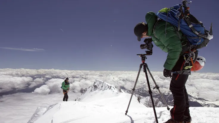
Elite guide Korra Pesce leads Google Street viewers to the top of Mont Blanc by carrying the Street View trekker up and down the Goûter Route, giving fans a first-person perspective with each step.
That view could change in the future, however, as it's unclear how Mont Blanc's ecology will shift with climate change. The mountain's glaciers are already receding as temperatures rise, and the newly captured Street View may serve as a time capsule for how the mountain looks now, Sandy Russell, Project Lead for Google's Mont Blanc Street View, wrote in the blog post.
"You can learn more about how the rising temperatures are directly affecting the mountain from legendary guide Patrick Gabarrou, who describes the glacial melt on the Mer de Glace," Russell said.
This is one of many projects Google Street View has tackled at extreme sites. Last year, Google created the first-ever vertical imagery collected of El Capitan in California's Yosemite National Park. In past years, the company has catalogued coral reefs, the base camp at Mount Everest and a float trip down Colorado's Yampa River.
Follow Laura Geggel on Twitter @LauraGeggel. Follow Live Science @livescience, Facebook & Google+. Original article on Live Science.