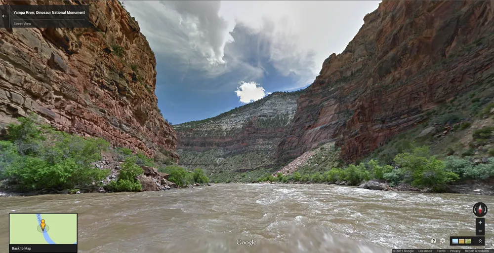
The deskbound can now explore one of the West's last wild rivers without leaving their chairs, thanks to a new project that uses Google Street View technology on a float trip down Colorado's Yampa River.
The virtual river trip, organized by nonprofit conservation organization American Rivers, travels through Dinosaur National Monument in Colorado and Utah, showcasing dramatic canyon walls with sedimentary rocks layered like a birthday cake and twisted by tectonic forces. The American Rivers team even strapped Google's cameras to their backs to capture side hikes up the canyons, ending at breathtaking overlooks.
The goals are to promote the conservation of the Yampa and to highlight a waterway that has been left largely as nature created it, with only two minor dams in its headwaters. The river runs 250 miles (402 kilometers) from the mountains of Colorado through Dinosaur National Monument, where it flows into the Green River. [Gallery: Take a Trip Down the Wild Yampa River]
Latest Videos From
"The wild Yampa is important because it shows that we can sustain vibrant agriculture while conserving endangered fish and supporting recreation," American Rivers' Matt Rice, director of the Colorado River Basin Programs, said in a statement.
Capturing the view
In 2014, American Rivers released the first "River View" project, a 286-mile-long (460 km) float down the Colorado River. The Yampa project was similar: Working with local rafting outfitter O.A.R.S., and partnering with the conservation group Friends of the Yampa, American Rivers loaded one of Google's Street View Trekker cameras onto a raft and launched on a four-day float trip from Craig, Colorado. The trip ended near Vernal, Utah, after the Yampa met the Green River.
The Google cameras snapped 360-degree panoramas every few seconds of the trip, which were then stitched together to create a simulation of the stunning scenery. As with Google Street View, computer users can drop a person-shaped pin on the river and then click through to explore.
"We are excited and hopeful that this new tool will bring increased awareness of the exceptional Yampa River, and we are positive that these 'virtual visits' to the Yampa will lead to more people wanting to help protect this magical place,” Soren Jespersen, board president of Friends of the Yampa, said in a statement.
Conserving the Yampa
So far, the Yampa has been a model for what wild rivers could be, according to American Rivers. But that could change.
"Unfortunately, because of its abundant water, increased demand and diminishing supplies in the Colorado River basin due to climate change, the Yampa River will continue to be a target for diversion," Rice wrote in an October 2014 blog post about the river.
Colorado is currently developing a plan to tackle the question of how to manage the state's water sustainably over the coming decades. Fortunately for the Yampa, the first draft of this plan, released in December 2014, prioritized the conservation of this river. The draft plan is now open for public review, with a final version expected in December 2015. American Rivers is trying to raise awareness of the Yampa's benefits and challenges before then, to ensure that the river remains a priority in the final plan.
Users can explore the Yampa River virtual tour on American Rivers' website.
Follow Stephanie Pappas on Twitter and Google+. Follow us @livescience, Facebook & Google+. Original article on Live Science.