
 Live Science Plus


In Photos: Take a Trip Down the Wild Yampa River

The Yampa River, one of the West's last wild rivers, begins in the mountains of Colorado and travels 250 miles (402 kilometers) through Dinosaur National Monument, toward its confluence with the Green River in Utah. Now, Google Maps users can take a virtual raft trip down the Yampa with a new Google Street View treatment of the river created in partnership with the nonprofit American Rivers.
A trip to remember

Here, the Google Street View cameras capture the first raft on the float trip traversing the run's largest rapid, the Warm Springs Rapid. (Credit: American Rivers)

Designed by Mother Nature
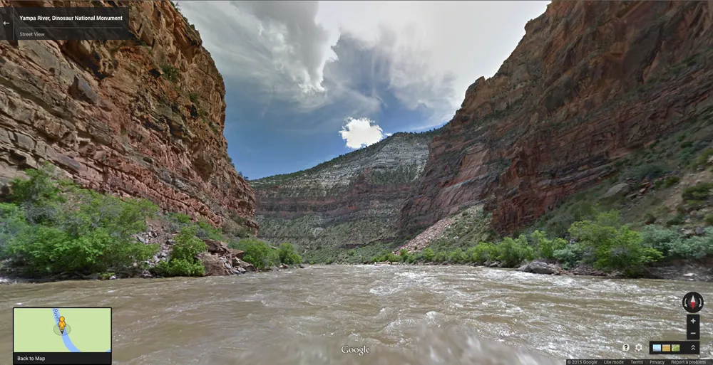
The Yampa river is a "wild" river, with only two small reservoirs near its headwaters that do not contain its spring runoff. That makes it one of the few naturally flowing rivers left in the western United States, according to American Rivers. The last 72 miles (116 km) of the river's path take it through Dinosaur National Monument's dramatic canyons, seen here. (Credit: American Rivers)
Another adventure

American Rivers first partnered with Google Maps to take the Internet giant's Street View cameras on a float trip down the Colorado River (the waterway that carved the Grand Canyon). The Yampa is the second "River View" project by the nonprofit organization, which partnered with the local conservation group Friends of the Yampa and the outfitter O.A.R.S. to complete the project. (Credit: American Rivers)
Get the world’s most fascinating discoveries delivered straight to your inbox.
Rivers for rafting

The Yampa River float trip actually ended on the Green River, another premier rafting river in the West. Here, the American Rivers team floats near Buck Island on the Green River in Utah. The Green River begins in Wyoming and travels all the way to the Colorado River in southern Utah. (Credit: American Rivers)
Keeping track of it all

Devin Dotson of American Rivers carries the Google Street View Trekker camera up a hiking trail to Harding Hole Overlook. The goal of the project was to raise awareness of the Yampa as one of the last wild rivers in the West, and to call for the protection of the river in the future. The state of Colorado is currently drafting a water plan, with a final version due by the end of 2015. The draft version of the plan, released in December 2014, prioritizes protection of the Yampa River. American Rivers hopes to secure that protection in the final plan, despite upcoming challenges from drought and climate change. (Credit: American Rivers)
A wild running river

The Harding Hole Overlook provides a view of the Yampa, framed by layer-cake canyons in Dinosaur National Monument. A steep climb from the Yampa Bench road in the park leads up to this breathtaking view — or you can save yourself the sweat and check it out on Google Maps. Devin Dotson of American Rivers poses with a Google Street View camera he used to capture panoramas of the hike. (Credit: American Rivers)
Unmeasured value

A view of the Yampa River from Harding Hole Overlook in Dinosaur National Monument. Located in northwest Colorado, the national monument protects 328 square miles (850 square km) and 105 miles (170 km) of river, according to the National Park Service (NPS).
"We hope the release of the Yampa River Google Street View will bring greater awareness to this incredible resource," Dinosaur National Monument superintendent Mark Foust said in a statement. "As the last natural flowing large tributary of the entire Colorado River system, the Yampa River preserves an amazing array of plant and animal communities along with the natural cycles they depend upon. This technology will provide people who may never get the opportunity to see the Yampa River in person to learn about the river and its ecological and wilderness values.” (Credit: Ken Neubrecker, American Rivers)
Into the Canyons

The American Rivers team is dwarfed by sheer rock walls in the canyons of Dinosaur National Monument. About 15,000 people visit the park each year, according to the NPS. Dinosaur fossils are visible embedded in quarries in the park, and petroglyphs decorate some of the cliffs, some left by the Fremont Indians who inhabited the region as long as 1,200 years ago. Ute and Shoshone later came to the area, followed by Spanish explorers. (Credit: American Rivers)
Island Park

The Green River spreads out and calms down at Island Park in Dinosaur National Monument, on the Utah side of the park. Fremont Indian petroglyphs, and an 1880s cattle ranch are among the attractions at this spot. (Credit: American Rivers)
Pucker up

Most of the Yampa River float trip offers up mild to moderate whitewater, but the Warm Springs Rapid near the end of the trip is both anticipated and feared by rafters. According to the NPS, the rapid is the result of a debris flow from the canyon that occurred in 1965. Additional rockfall in 2012 complicated the rapid, leaving lots of new boulders for river runners to navigate. Here, the American Rivers team kisses a rock formation called the Tiger Wall for luck before plunging into the rapid. (Credit: Ken Neubrecker, American Rivers)
Earning its name

The impressive Split Mountain on the Green River comes by its name honestly. Over millennia, the Green River gradually eroded a canyon right through this mountain. The 19th-century geologist and explorer John Wesley Powell gave Split Mountain its name on one of his expeditions. This spot, near Vernal, Utah, is where rafters typically take out after a Yampa River run. (Credit: Ken Neubrecker, American Rivers)
A beautiful ecosystem

A view of Split Mountain in Utah and the American Rivers team. The group's four-day float captured 72 miles (116 km) of river, starting at Deerlodge Park near Craig, Colorado, and ending here.
"We first partnered with American Rivers for the Colorado River Street View project last year. Today, we're very proud that American River has successfully collected their first Street View river collection entirely on their own as part of our Trekker Loan Program,” Karin Tuxen-Bettman, a program manager at Google Earth Outreach, said in a statement. "By making this imagery of the Yampa River in Dinosaur National Monument available online, we hope this inspires viewers from around the world to take an active interest in exploring, protecting, and participating in this beautiful intact ecosystem.” (Credit: Ken Neubrecker, American Rivers)
Where two rivers meet

The Yampa River flows into the Green River at Echo Park, marked by this standout formation called Steamboat Rock. Where the two rivers meet, the Yampa looks brown and muddy, and the Green River lives up to its name with a clear greenish hue. (Credit: Ken Neubrecker, American Rivers)
Ride the rapids

Get ready for a wild ride — the Warm Springs Rapid is the most white-knuckle whitewater on the four-day float captured for Google Maps. This is a Class IV rapid, and because it's in the middle of a multi-day trip, flipping over a raft here typically results in a wet, muddy night, according to AmericanWhitewater.org. (Credit: Ken Neubrecker, American Rivers)
Navigate the river yourself

The Trekker camera on loan from Google Maps is visible at the confluence of the Yampa and Green Rivers. Every few seconds during the four-day float trip, the camera snapped a 360-degree panorama. Now, Google Maps users can drop a pin on the river and navigate it just as they would Google Street View. (Credit: Ken Neubrecker, American Rivers)
Layers of history

An astounding 23 layers of rock are exposed in this cliffside in Dinosaur National Monument, one of the most complete rock records on display in any National Park. The record spans 1.2 billion years, according to the NPS, and captures times when the region was everything from a shallow sea to a vast desert. The Yampa River, visible in the foreground, carved the canyon that makes these rock layers visible. (Credit: American Rivers)
Follow Stephanie Pappas on Twitter and Google+. Follow us @livescience, Facebook & Google+.

Stephanie Pappas is a contributing writer for Live Science, covering topics ranging from geoscience to archaeology to the human brain and behavior. She was previously a senior writer for Live Science but is now a freelancer based in Denver, Colorado, and regularly contributes to Scientific American and The Monitor, the monthly magazine of the American Psychological Association. Stephanie received a bachelor's degree in psychology from the University of South Carolina and a graduate certificate in science communication from the University of California, Santa Cruz.