


27 weirdest things on Google Earth
Google Earth and satellite imagery has revealed some strange things, from secret military bunkers in China to phantom islands to a mysterious pentagram in Kazakhstan.

There are many, many weird things seen on Google Earth. The service, which was launched in 2005, compiles images from various sources, from satellites in geosynchronous orbit that snap low-resolution photos from tens of thousands of miles above Earth, to satellites closer to Earth that capture higher-resolution shots, and even aerial photos taken from airplanes, kites, drones and even balloons.
The imagery is available to anyone, and people across the world have taken advantage of this rich resource to find weird and wonderful places that may have otherwise remained undiscovered.
From a boneyard of military planes, to a polka-dot pattern created by ants, to mysterious structures etched into the Gobi Desert and even a strange black island in the Pacific Ocean, Google Earth — and its netizens — have helped bring these places to light. Here's a look at some of the strangest.
Swastika in Kazakhstan
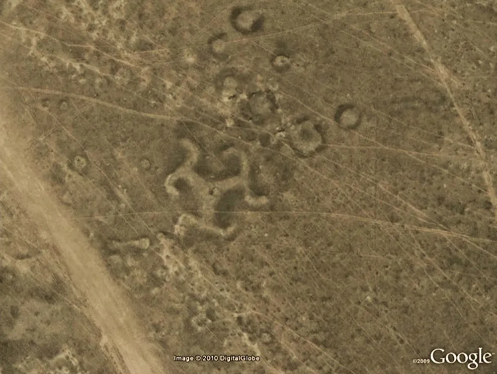
A swastika-shaped geoglyph can be seen from above Kazakhstan.
Scientists discovered more than 50 geoglyphs across northern Kazakhstan in Central Asia, including this swastika-shaped design. Though the swastika symbol was created from timber, many of the geoglyphs were made of earthen mounds. The geoglyphs seem to date back 2,000 years. At the time, swastikas were not uncommon across Europe and Asia and were not of course affiliated with any political beliefs. [Read more about the swastika geoglyphs and other Kazakhstan designs]
Island in a lake on an island in a lake on an island in Philippines

An island-in-a-lake-on-an-island-in-a-lake-on-an-island.
This Google Earth image is an eye-full and a mouthful, as it's an island-in-a-lake-on-an-island-in-a-lake-on-an-island. Yes, Google Earth captured this image showing a tiny island that resides inside a crater lake on an island called Volcano Island in a lake called Taal lake on the Philippine island of Luzon. For years apparently, this phenomenon was thought to be the largest of its kind spied by Google Earth. However, it turns out that accolade goes to a 4-acre spit of land in northern Canada where no human has likely stepped foot.
Wheel structures in Azraq Oasis in Jordan
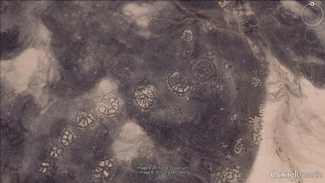
Wheel structures in the Azraq Oasis in Jordan, as seen in this Google Earth image.
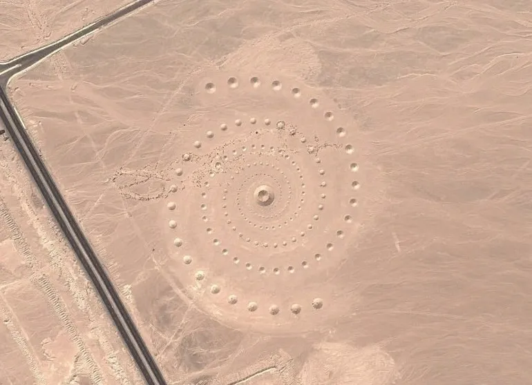
Google Earth has spied some old artistry etched into the surface of the planet, including wheel-shaped geometric structures that may date back some 8,500 years, making them older than Peru's geoglyphs called Nazca Lines. Some of these spoked designs that dot Jordan's Azraq Oasis seem to be positioned in a way that aligns with sunrise on the winter solstice. A team of scientists with the Aerial Photographic Archive for Archaeology in the Middle East (APAAME) have been investigating wheel structures (also called "works of the old men") with satellite imagery available through Google Earth.
The wheels vary in their design, with some showing spokes that radiate from the center, others with just one or two bars rather than spokes and still others not circular at all and instead shaped like squares, rectangles or triangles, the researchers have found.
Get the world’s most fascinating discoveries delivered straight to your inbox.
The wheels seen in this image are in the Azraq Oasis and have spokes with a southeast-northwest orientation, possibly aligning with the winter solstice sunrise.
Bull's eye in wheel structures in Saudi Arabia

Some of the "wheels" found in Saudi Arabia have a bull's-eye design.
One type of these "wheels" in the Middle East looks like a bull's-eye, with three triangles pointing toward the eye and small piles of stones leading from the triangles toward the bull's-eye wheel. David Kennedy, of the University of Western Australia, who co-directs the project, calls it "a central bull's-eye tomb with, in this case, three triangles each with at least a part of a connecting line of stone heaps running to the center."
Unexcavated pyramid in Egypt
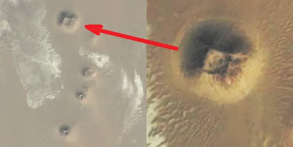
Natural or man-made?
This image from Google Earth shows an anomaly that some believe could be an unexcavated pyramid. Dozens of anomalies in Egypt have been detected using Google Earth in the past five years; however, there is a debate as to whether they represent natural features or artificial structures. More excavations are needed, but the security and economic situation in Egypt has limited the number and size of excavations.
More potential eroded pyramids in Egypt

Eroded Egyptian pyramids or geologic features?
Eroded Egyptian pyramids or geologic features?
Phantom Sandy Island near New Caledonia

The mysterious "Sandy Island"
In 2012, a group of Australian researchers "undiscovered" an island the size of Manhattan in the South Pacific. A mysterious place called Sandy Island had popped up on maps, northwest of New Caledonia. It even showed up as a black polygon on Google Earth. But when scientists sailed there in November 2012, they found open water instead of solid ground.
In an obituary for the island published in April 2013, the researchers explained why the phantom landmass had been included on some maps for more than a century, pointing to some human errors and a possible pumice raft.
Pentagram in Kazakhstan
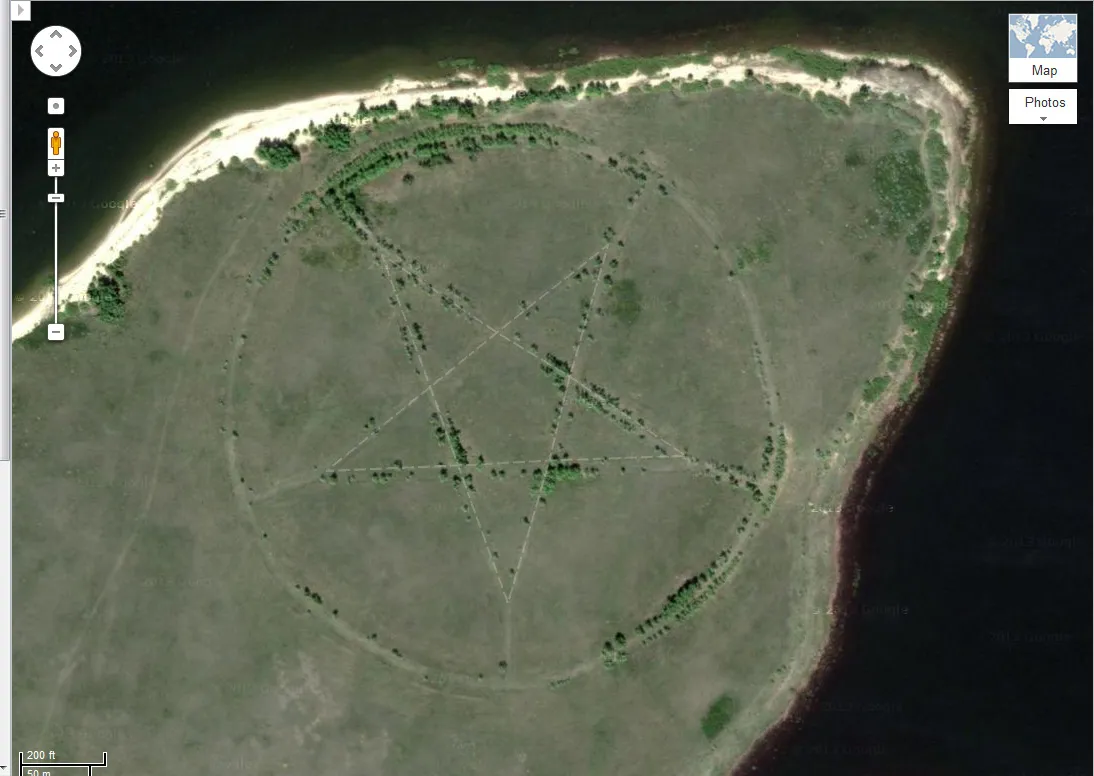
On the wind-blown steppes of Central Asia, in an isolated corner of Kazakhstan, there's a large pentagram, measuring roughly 1,200 feet (366 meters) in diameter, etched into Earth's surface. The five-pointed star surrounded by a circle, located on the southern shore of the Upper Tobol Reservoir, shows up vividly on Google Maps, the online version of the more detailed Google Earth.
Many online comments linked the site with devil worship, nefarious religious sects or denizens of the underworld. Instead, the pentagram turns out to be the outline of a park made in the form of a star; the star is marked by roadways that are now lined with trees, making the star shape even more distinct in aerial photos.
Abandoned launch sites at Oahu Defense Area in Hawaii

This Google Earth image shows the Oahu Defense Area in Hawaii, which was equipped with missiles in open air with earthen revetments, or embankments, between paired launch sites, shown here in 1968.
Nike missiles, which were supersonic surface-to-air missiles, sat ready to launch at nearly 300 sites across the United States during a period of the Cold War, from 1954 to the 1970s. Some of those missiles even carried nuclear warheads. Those missiles became obsolete with the advent of long-range intercontinental ballistic missiles (ICBMs).
David Tewksbury, a GIS (geographic information system) specialist at Hamilton College in New York, aimed to preserve a visual record of the abandoned Nike missile launch sites before they vanish — either as a result of being reclaimed by nature, repurposed by the military or redeveloped. His plan is to build a geo-referenced database so that anyone can research the Nike missile sites through Google Earth.
Here, one of those sites, the Oahu Defense Area in Hawaii, is shown in 1968. The site was once equipped with missiles in the open air, with embankments between paired launch sites.
Spiral art installation "Desert Breath" in Egypt
desert-breath
A spiral portal to an alternate universe? Maybe an alien message? Or an ancient monument to a supernatural being? This giant spiral design in the desolate Egyptian desert, not far from the shores of the Red Sea, is an art installation called Desert Breath. In March 2007, Danae Stratou, Alexandra Stratou and Stella Constantinides created the 1 million square foot (100,000 square meters) artwork meant to celebrate "the desert as a state of mind, a landscape of the mind," the artists say on their website.
Looting holes in Apamea, Syria

Apamea looted in satellite imagery
The civil war in Syria has imperilled hundreds of archaeological sites, including causing damage to all six of the UNESCO World Heritage Sites in the country, which is considered one of the oldest occupied areas of the Earth. Satellites, in particular, have shown much of this devastation, with some of the strangest imagery showing destruction in Apamea. There, Google Earth images have revealed the entire ancient Roman city has been pockmarked with holes dug by looters since the start of the civil war.
"It looks like the surface of the moon," Emma Cunliffe, an archaeology researcher at Durham University in England, who has published a report documenting archeological damage in Syria, told Live Science in 2013. "In eight months, the looted area exceeded the total excavated area."
Blood lake outside Sadr City, Iraq

Lake of blood?
Outside Sadr City in Iraq, at coordinates 33.396157° N, 44.486926° E, lies a blood-red lake. There is, as yet, no official explanation for the color of this strange body of water.
Polka-dot formation on Grand Canyon made by ants
This weird polka-dot pattern in the vegetation near a volcano on the rim of the Grand Canyon could be the work of red harvester ants.
An odd polka-dot pattern near the cinder cone volcano dubbed Vulcan's Throne on the north rim of the Grand Canyon may have a simple explanation: ants. Turns out, the desert around the Grand Canyon is home to red harvester ants (Pogonomyrmex barbatus).
These pesky critters can create nesting mounds spanning some 47 inches (120 centimeters) across and are typically surrounded by bare ground up to 108 square feet (10 square meters), according to physicist Amelia Carolina Sparavigna, a specialist in image processing and satellite imagery analysis at the Politecnico of Torino in Ital. Sparavigna discusses her theory in a scientific paper posted online on Jan. 11, 2016 - the paper has yet to be peer-reviewed. The mounds may be responsible for the aerial pattern of scattered circles, though Sparavigna says on-the-ground confirmation is needed.
Island, in a lake, on an island, in a lake, on an island near Victoria Canada

An
The world's largest "island, in a lake, on an island, in a lake, on an island" is a narrow, four-acre strip of land in Canada located at exactly 69.793° N, 108.241° W. The nameless island (that little-tilde shaped squiggle of green) lolls across the center of a small lake, which is itself encapsulated by a slightly larger island. That resides inside one of a series of long finger lakes located 75 miles inland from the southern coast of Victoria Island, a land feature in Northern Canada.
This little "sub-sub-sub island" would never have received its strange distinction if not for careful trolling of Google Earth by map geeks around the world. In all likelihood, no human has ever actually set foot there.
Boneyard at Davis Monthan Air Force Base in Arizona

The boneyard
The Davis Monthan Air Force Base in Tucson, Ariz., is where U.S. military planes go to die. Dubbed "the boneyard," this 2,600-acre cemetery of steel at coordinates 32 08'59.96" N, 110 50'09.03"W is closed to the general public, but Google Earth provides a high-resolution glimpse of what's inside: virtually every plane the military has flown since World War II — from the B-52 StratoFortress to the F-14 Tomcat — in various stages of decay.
The boneyard at Davis Monthan was used as the backdrop in the music video for "Learning to Fly" by rock music legend Tom Petty and the Heartbreakers. The band was shown performing among various aircraft hulks.
Word "Hamad" written on al Futaisi Island

This is what happens when you have far more money than sense
Hamad bin Hamdan al Nahyan, a billionaire Sheikh and member of Abu Dhabi's ruling family, has had his name carved into the sandy surface of al Futaisi Island, an island he owns in the Persian Gulf. At half a mile tall and 2 miles long altogether, the letters HAMAD may be the world's largest; regardless, they're visible from space.
Normally, words written in sand wash away, but these letters are large enough to form waterways that absorb the encroaching tide. Indeed, at the time these satellite photographs were taken, said tide can be seen flowing through the letters all the way to the M.
Aerial view of elephants in Chad

Wild View Elephants
Thought you might never get to see a herd of African elephants in the wild? Luckily, satellites captured a few high-resolution images of a herd on the move in Chad, at coordinates 10.903497 N,19.93229 E.
Church of Scientology Bunker in New Mexico
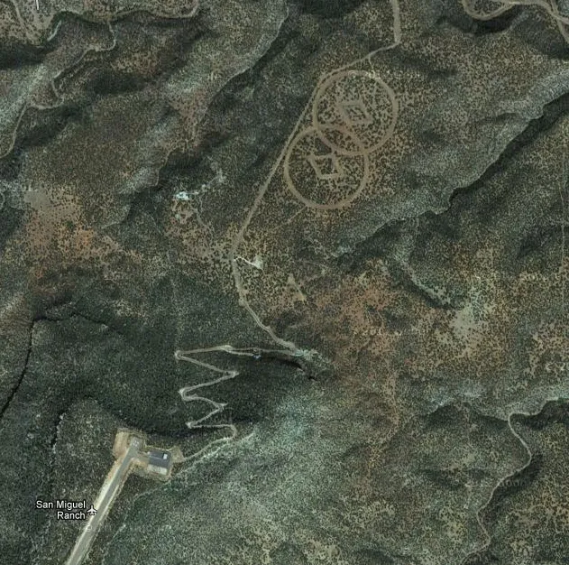
scientology-bunker
Found etched onto the desert floor near Mesa Huerfanita, New Mexico, are two large diamonds surrounded by a pair of overlapping circles. Author John Sweeney claimed that the site marks a hidden bunker belonging to the Church of Scientology.
According to their website, Scientology "is a religion that offers a precise path leading to a complete and certain understanding of one's true spiritual nature and one’s relationship to self, family, groups, Mankind, all life forms, the material universe, the spiritual universe and the Supreme Being," according to the organization's website. Such symbols on the desert floor are reportedly there to help guide these scientologists who return to Earth after fleeing a planetary "Armageddon," writes the Daily Mail. Of course, the symbols will likely remain a mystery.
Patterns etched in Gobi Desert

Mysterious structures and patterns etched into the surface of China's Gobi Desert.
Newfound Google Earth images have revealed an array of mysterious structures and patterns etched into the surface of China's Gobi Desert. According to experts, this is a secret military base, and the structures are used for a variety of purposes including weapons testing, spy satellite calibration and testing of radar instrumentation.
The most elaborate feature, an intricate grid of perfectly straight lines that weave back and forth every few hundred feet for 20 miles (33 kilometers), is most likely a Yagi antenna array, a device used for weather tracking and other atmospheric research.
KFC advertising in Chile hillside

Google Earth "mapvertising"
Considering the number of people who troll Google Earth in their free time, it isn't surprising that enormous advertisements have started popping up in remote areas for their viewing pleasure—a concept known as "mapvertising." The world's largest Coca-Cola logo, for example, can be seen at 18.5292 S, 70.2500 W on a hillside in Chile; it is said to be made of 70,000 empty Coca Cola bottles. A 87,500-square-foot picture of Colonel Sanders — the KFC logo— once appeared at 37.646163° N, 115.750819° W just off Extraterrestrial Highway in Nevada, but has since been removed.
Shipwreck of S.S. Jassim off Sudan

Sizable shipwreck
The S.S. Jassim, a Bolivian cargo ferry, ran aground and sank on the Wingate Reef off the coast of Sudan in 2003. At 265 feet (81 meters) long, it was once one of the largest shipwrecks visible on Google Earth, located at 19 38'45.99"N 37 17'42.17E, although it now appears to have sunk almost completely.
Landlocked lips in Darfur, Sudan

Landlocked lips
These luscious lips are a hill formation located in Gharb, Darfur, in Sudan at coordinates 12°22'13.32"N, 23°19'20.18"E.
Triangle UFO in Australia

Aussie UFO?
In Australia, at coordinates 30°30'38.44"S 115°22'56.03"E, a strange triangle dotted with bright lights appeared in the middle of a field. When first discovered in 2007, ufologists were quick to call it a "triangle UFO" caught in the act of hovering above Earth. Other Google Earth users said it may be an antenna associated with a nearby remote-controlled wind farm. With three sets of wires forming a triangle, and a tower in the middle, the antenna likely received and transmitted control signals.
Related: This weird Google Earth picture does not show a crashed UFO
Secret military base near Kashgar, China
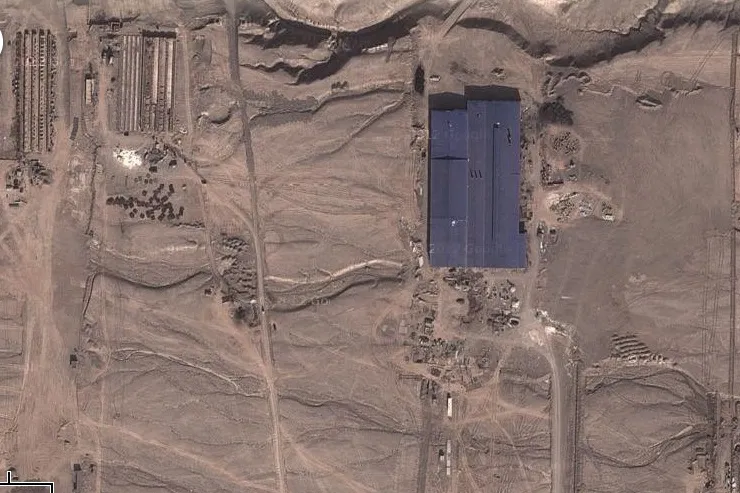
Google earth, satellite images, Chinese desert
A mysterious set of satellite images seen on Google Earth created a stir when an ex-CIA analyst told Wired.com he had discovered "structures" in the desert around Kashgar, a city in China's remote Western desert that is part of the Xinjiang province.
Some speculated the buildings at the site were part of a secret military base. But with further analysis, Stefan Geens, a technologist and geospatial blogger who has spent months in that part of China, said the site was likely part of a major manufacturing or economic center.
Mystery structures on Chinese satellite images

Another strange sight in China's Western desert
Here, another image of the strange site in the Chinese desert.
One structure in the complex did somewhat resemble a helicopter testing area, analysts said there's no reason it would necessarily be linked to military activities. Furthermore, the site is not ideal for a secret military base, since it's relatively close to a major population area and no towers or barriers were spotted, said Stuart Hamilton, former GIS program director at the Center for Geospatial Analysis at the College of William and Mary, and now a professor at Salisbury University in Maryland.
An untouched mountaintop rainforest

Mount Lico, in Mozambique, has a high-altitude rainforest sitting on its sheer slopes.
At times, it seems like humans have explored every nook and cranny of the land on Earth. But in 2018, researchers went somewhere that (almost) no one has ever been before, all thanks to Google Earth.
The destination was Mount Lico, Mozambique, where the research team discovered a high-altitude rainforest perched atop sheer slopes. Welsh conservation scientist Julian Bayliss first discovered the spot using Google Earth, The Verge reported. Actually visiting the forest required a dizzying 400-foot (123 m) climb up a vertical granite face. On top, the scientists found a remarkable ecosystem populated by butterflies, spiders and small mammals. A few old, handmade pots revealed that someone else had once made the climb, perhaps 100 years before. No one knew for sure who left the pots behind.
Blacked out mystery island
Vostok Island appears to be blacked out on Google Earth.
Vostok Island, a small, uninhabited coral island that sits in the central Pacific Ocean, appears blacked out on Google Earth, sparking a range of conspiracy theories about it — including it being a secret military base. In reality, the centre of the island is covered by Pisonia grandis trees rooted in thick, peat soil. These trees are so dense and dark, that from above the foliage gives the island the appearance of a weird black hole.
Belonging to Kiribati, the island, which is about 0.8 miles (1.3 kilometers) long, was first discovered in 1820. It is composed of coral sand and rubble, with no lagoon or freshwater. There is no evidence the island has ever been inhabited, although rats there indicate it may have been visited by ancient Polynesians at some point.

Ben Biggs is a keen and experienced science and technology writer, published book author, and editor of the award-winning magazine, How It Works. He has also spent many years writing and editing for technology and video games outlets, later becoming the editor of All About Space and then, Real Crime magazine.