


Hurricane Ian to reach Category 3 before hitting Cuba, turning toward West Florida
The storm may slightly weaken before hitting Florida.
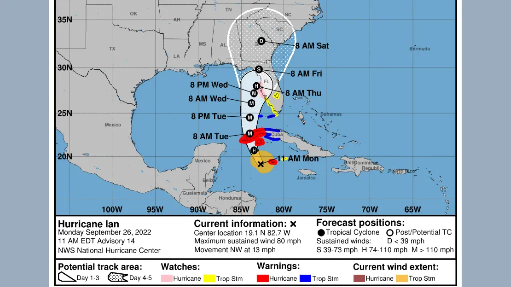
Hurricane Ian, the fourth hurricane of the 2022 Atlantic season, strengthened from a tropical storm into a Category 1 hurricane in the early hours of Monday morning (Sept. 26), and it's expected to continue intensifying into at least a Category 3 storm as it nears Cuba's western shore, the National Hurricane Center (NHC) warned. At that point, its maximum sustained winds will exceed 111 mph (178 km/h).
The center of the hurricane will likely pass near or west of the Cayman Islands sometime on Monday and then sweep near or over western Cuba on Monday night and Tuesday morning (Sept. 27). It's then predicted to move into the southeastern Gulf of Mexico, passing west of the Florida Keys by Tuesday evening, and begin approaching the west coast of Florida by Wednesday (Sept. 28), the NHC said.
As of 11:00 a.m. ET on Sept. 26, the hurricane's maximum sustained winds hovered around 80 mph (130 km/h), the NHC reported. Hurricane Ian is expected to drop 3 to 6 inches (7.6 to 15.2 centimeters) of rain on the Cayman Islands, with some areas getting up to 8 inches (20.3 cm). Western Cuba will get about 6 to 10 inches (15.2 to 25.4 cm) of rain, with some areas getting up to 16 inches (40.6 cm).
"Life-threatening storm surge, hurricane-force winds, flash floods and possible mudslides are expected in portions of western Cuba beginning this evening and continuing into Tuesday," the NHC warned Monday morning. "Devastating wind damage is possible where the core of Ian moves across western Cuba."
Related: Hurricane season 2022: How long it lasts and what to expect
The NHC predicts that Ian will pass over Cuba quickly and may strengthen even more as it moves into the Gulf. Before the storm hits Florida, weather conditions to the northwest of the cyclone will likely weaken the storm, "but Ian is expected to remain at or near major hurricane strength" — meaning Category 3 or above — "as it passes near the west-central coast of Florida on Wednesday and Thursday," the center noted.
There's still uncertainty as to exactly where Ian will make landfall on the west coast of Florida, as current models project that the storm could come ashore south of Tampa Bay, in the middle of the Panhandle, or at some location in between, The Miami Herald reported on Monday morning.
Get the world’s most fascinating discoveries delivered straight to your inbox.
"Regardless of Ian's exact track and intensity, there is a risk of a life-threatening storm surge, hurricane-force winds, and heavy rainfall along the west coast of Florida and the Florida Panhandle by the middle of this week," the NHC stated in its 5:00 a.m. ET advisory on Sept. 26. "Tropical Storm and Hurricane Watches have been issued for a portion of the west coast of Florida and additional watches may be required later today."
RELATED STORIES
At this point, the greatest possible storm surges are predicted for the region between the Anclote River and the middle of Longboat Key, Florida — an area that includes Tampa Bay. If peak storm surge coincides with high tide in the region, the storm surge could reach 5 to 10 feet (1.5 to 3 meters) high. Significant storm surges are also possible farther south along the coast and into the Florida Keys.
Through Thursday (Sept. 29), the Keys could get about 4 to 6 inches (10.2 to 15.2 cm) of rain, the NHC predicts, while central West Florida will likely get 8 to 10 inches (20.3 to 25.4 cm), with local maximums up to 15 inches (38.1 cm). The rest of the Florida peninsula could get 3 to 8 inches (7.6 to 20.3 cm) of rain in that time. Then on Friday (Sept. 30) and Saturday (Oct. 1), heavy rainfall will likely inundate North Florida and eastern portions of the Florida Panhandle.
Originally published on Live Science.

Nicoletta Lanese is the health channel editor at Live Science and was previously a news editor and staff writer at the site. She is a recipient of the 2026 AHCJ International Health Study Fellowship, with a project focused on antibiotic stewardship practices in Japan and the U.S. They hold a graduate certificate in science communication from UC Santa Cruz and degrees in neuroscience and dance from the University of Florida. Beyond Live Science, Lanese's work has appeared in The Scientist, Science News, the Mercury News, Mongabay and Stanford Medicine Magazine, among other outlets. Based in NYC, she also remains involved in dance and performs in local choreographers' work.