
 Live Science Plus


Hurricane Fiona hits the Dominican Republic after wiping out Puerto Rico's power grid
The storm hit as a Category 1.

Hurricane Fiona struck the eastern coast of the Dominican Republic on Monday (Sept. 19) after the Category 1 storm had caused widespread flooding, landslides and a territory-wide blackout in Puerto Rico the day before.
Fiona strengthened from a tropical storm to a hurricane on Sunday morning (Sept. 18), and the National Hurricane Center (NHC) warned that the approaching cyclone would likely bring "torrential rains and mudslides" to both Puerto Rico and the Dominican Republic.
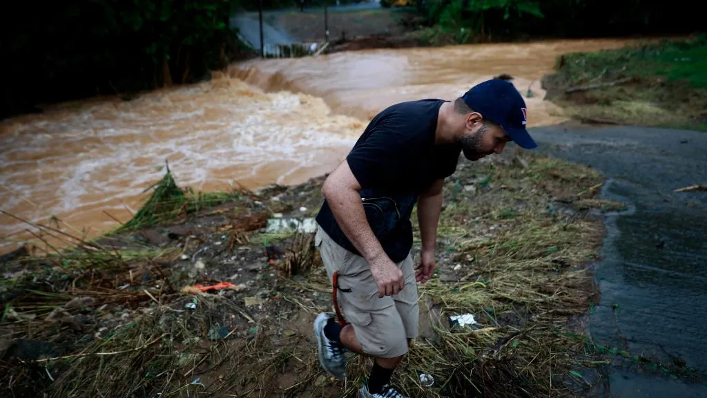
The storm slammed into the southwestern coast of Puerto Rico at about 3:20 p.m. local time on Sunday, bringing with it maximum sustained winds of 85 mph (140 km/h). The NHC predicted that the storm would dump some 12 to 18 inches (30 to 45 centimeters) of rain onto the island, with select areas in eastern and southern Puerto Rico getting up to 30 inches (76 cm).
Hundreds of people were evacuated or rescued from impacted areas as the floodwaters swiftly rose, and the destructive floods triggered large landslides and destroyed a bridge in the central mountain town of Utuado, according to The Associated Press. Fiona also plunged Puerto Rico into an island-wide black out, according to the website PowerOutage.us, which tracks power interruptions.
Related: Hurricane season 2022: How long it lasts and what to expect
"The electric system has experienced several transmission line outages which have contributed to an island-wide power outage," Luma, the energy company that operates and manages Puerto Rico's electric power transmission and distribution system, wrote on its website.
By Monday morning, Luma had restored power to about 100,000 customers, The New York Times reported. But "given the size and scope of the outage, as well as ongoing impacts of Hurricane Fiona, full power restoration could take several days," the Luma website reads.
Get the world’s most fascinating discoveries delivered straight to your inbox.
RELATED STORIES
Fiona's outer bands are expected to continue dropping heavy rain onto Puerto Rico into Monday afternoon, even as the storm moves west, according to The New York Times. The hurricane made landfall in the Dominican Republic early Monday morning, around 3:30 a.m. local time, with maximum sustained winds of 90 mph (150 km/h), according to NHC.
"Life-threatening flash and urban flooding is likely for eastern portions of the Dominican Republic," NHC warned. "Storm surge will raise water levels by as much as 3 to 5 feet [0.9 to 1.5 meters] above normal tide levels along the immediate coast in areas of onshore winds in the Dominican Republic."
Fiona is expected to pass over the eastern Dominican Republic and emerge into the southwestern Atlantic by Monday afternoon, the NHC predicts. By Tuesday (Sept. 20), its center will pass near or to the east of the Turks and Caicos Islands; by Wednesday (Sept. 21), the storm will likely strengthen into a "major hurricane," meaning a Category 3 or higher.
Originally published on Live Science.

Nicoletta Lanese is the health channel editor at Live Science and was previously a news editor and staff writer at the site. She is a recipient of the 2026 AHCJ International Health Study Fellowship, with a project focused on antibiotic stewardship practices in Japan and the U.S. They hold a graduate certificate in science communication from UC Santa Cruz and degrees in neuroscience and dance from the University of Florida. Beyond Live Science, Lanese's work has appeared in The Scientist, Science News, the Mercury News, Mongabay and Stanford Medicine Magazine, among other outlets. Based in NYC, she also remains involved in dance and performs in local choreographers' work.