It's quick and easy to access Live Science Plus, simply enter your email below. We'll send you a confirmation and sign you up for our daily newsletter, keeping you up to date with the latest science news.
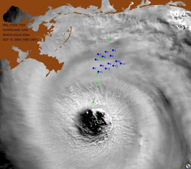
The eye of Hurricane Ivan is just southeast of the boot of Louisiana. Green dots indicate the storm's path. Moorings are shown as blue dots. This satellite image from NASA's Moderate Resolution Imaging Spectroradiometer (MODIS) on Sept. 15, 2004 was produced by the Ocean Optics Section at the Naval Research Laboratory, Stennis Space Center, MS. Image courtesy of Robert A. Arnone, head of the Ocean Processes Branch of the Naval Research Laboratory
Waves nearly 100 feet tall were recorded last year in the Gulf of Mexico when Hurricane Ivan headed toward shore, forcing scientists to rethink what is normal.
The center of the category 4 hurricane, with winds raging up to 150 miles per hour, passed right over six of the Naval Research Laboratory's wave-tide gauges, churning up waves more than 90 feet high.
"We were a little surprised that the waves were so large," Bill Teague of the Naval Research Laboratory (NRL) at Stennis Space Center told LiveScience. "But the reason we were surprised is because this was the first time measurements had been taken of large waves."
Teague and his colleagues at the NRL had placed several wave-tide gauges in the Gulf of Mexico to study water currents and wave heights. The gauges measured the pressure of the water above them which translates to wave height.
The findings are detailed in the Aug. 5 issue of the journal Science.
'Fairly common'
The average of the largest 1/3 of the waves that passed the devices was about 58 feet.
Sign up for the Live Science daily newsletter now
Get the world’s most fascinating discoveries delivered straight to your inbox.
"It was very fortuitous for our moorings to be installed right in the path of Ivan," Teague said. "From theses measurements we have learned that waves over 90 feet are not rogue waves, but are actually fairly common in hurricanes."
Wave measuring devices are commonly destroyed or swept away by turbulent waters like these, but Teague's instruments, which sit on the sea floor rather than bob on the water''s surface, made it through the storm.
According to Teague, the size of extreme waves caused by hurricanes has long been underestimated.
"The measurements that we made will be very useful in wave prediction models," he said.
How waves grow
While tsunamis are generally created by catastrophic disturbances on the sea floor, regular waves are generated by wind. The area of water affected by wind is called a ?fetch.'
As wind blows across the fetch, tiny "capillary" waves form. They're about the thickness of a hair. These tiny waves eventually create little ripples, which cause more friction with the wind, and more energy is transferred from the wind to the water.
"The rougher the water becomes, the easier it is for the wind to transfer its energy," said David Wang, also of the NRL.
When wind blows harder of over a longer time period, more energy is transferred to the water. The biggest waves don't come from the fastest winds, which can blow erratically over a small area, but rather from winds that blow more constantly across large stretches of water, creating a longer fetch.
Hurricanes create large, local waves over small areas, but the waves don't always make it all the way to the shore. The big waves that crash on our shores are from large storms that move steadily over across thousands of miles of ocean.
Long trek
For instance, the sets of waves that surfers drool over at Huntington Beach in Southern California originate from storms in the North Pacific Ocean. The waves travel over 3,000 miles over the course of four days. Antarctic storms produce waves that travel even further.
Although they can besuper tall, these extreme waves only have a period – the time between the crest of one wave and the next – of about 10 seconds and a wavelength of a few hundred feet.
Tsunamis, on the other hand, can have a period more than an hour long and a wavelength more than a hundred miles.
"Tsunamis are only a foot or two in height because they are so long," Teague said. "They only get huge when they hit shallow water and begin to back-up on themselves."
There isn't much need to worry about these extreme hurricane waves reaching the shore, though.
"They break up and dissipate when they start feeling the bottom. They don't last that long," Teague said. "They don't travel that far, but they can bust up everything [in their path]."
Bjorn Carey is the science information officer at Stanford University. He has written and edited for various news outlets, including Live Science's Life's Little Mysteries, Space.com and Popular Science. When it comes to reporting on and explaining wacky science and weird news, Bjorn is your guy. He currently lives in the San Francisco Bay Area with his beautiful son and wife.

 Live Science Plus