It's quick and easy to access Live Science Plus, simply enter your email below. We'll send you a confirmation and sign you up for our daily newsletter, keeping you up to date with the latest science news.
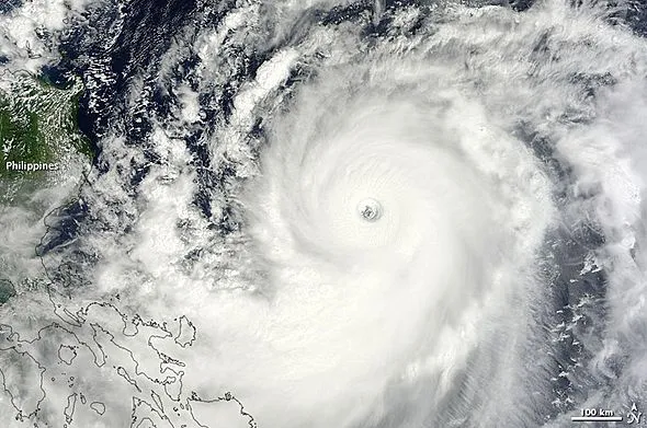
This image of Jelawat was taken on Tuesday, Sept. 25, 2012, when the storm was a super typhoon. According to the Philippines newspaper Zamboanga Today, outer bands of the large typhoon, known to locals as "Lawin," has caused flooding and forced evacuations in Zambo City.
(Image credit: Courtesy of NASA's Earth Observatory.)
Jelawat in the Western Pacific is forecast to curve across Okinawa and the Japan mainland, bringing flooding rain, monstrous seas and damaging winds.
According to World Weather Expert Jason Nicholls, "While Jelawat, a super typhoon as of Wednesday midday EDT, Sept 26, 2012, is forecast to weaken the next few days, it is likely to curve northward, then northeastward this weekend with direct, dangerous impacts on Japan."
This image of Jelawat was taken on Tuesday, Sept. 25, 2012, when the storm was a super typhoon, and appears courtesy of NASA's Earth Observatory. According to the Philippines newspaper Zamboanga Today, outer bands of the large typhoon, known to locals as "Lawin," has caused flooding and forced evacuations in Zambo City.
The powerful system was cruising northeast of the island of Luzon in the Philippines Wednesday with maximum sustained winds of 150 mph and gusts to 185 mph. Estimated seas near and just northeast of the center of circulation were between 40 and 50 feet. The AccuWeather.com Hurricane Center has the latest statistics on Jelawat.
Jelawat will track through progressively cooler waters and drier air. Both will work to weaken Jelawat somewhat before reaching the Ryuku Islands, but the system will remain quite strong over deep warm water into the end of the week.
Stronger steering-level winds farther north will not only begin to break down the storm as it moves along this weekend, but they will also turn Jelawat toward Japan and cause its forward speed to increase.
Sign up for the Live Science daily newsletter now
Get the world’s most fascinating discoveries delivered straight to your inbox.
(Image credit: AccuWeather.com)
"People and interests in the the Ryukyu Islands, including Okinawa, should be prepared for a direct hit with an accelerating tropical cyclone of typhoon or hurricane strength," Nichols said. "The islands can be subject to damaging winds in excess of 75 mph, dangerous surf and seas and torrential rain and flooding."
Impact will begin on the Ryukyu Islands early this weekend with building seas, increasing wind and squalls with the worst conditions Sunday, local time, and late Saturday EDT.
By the time the system reaches the latitude of mainland Japan early next week, it may be a tropical storm or transitioning to a non-tropical system.
"Despite the projected weakening before hitting mainland Japan, the terrain may squeeze out a foot of rain in some areas, potentially leading to major flooding," Nicholls added.
Tropical storm conditions are possible in Tokyo Monday into Tuesday, local time.
According to World Weather Expert, Jim Andrews, "The projected path of Jelawat takes the worst weather east of Taiwan, but the island will experience rough seas, locally gusty winds and heavy rain on the windward facing mountainsides."
In addition to the risk to lives and property in the region, travel and shipping disruptions are possible in the proximity of the storm in the Philippine Sea region. Seas will remain rough in the region into early next week.
Ewiniar, a tropical storm as of midday Wednesday, was buffeting the small islands east of mainland Japan and also contributing to rough seas in the region.
The eye of Jelawat is clearly visible in the Western Pacific on Wednesday, Sept. 26, 2012. Ewiniar was spinning east of Japan.
(Image credit: Joint Typhoon Warning Center.)
Ewiniar is not a threat to mainland Japan and is helping to drag dry air southward in the path of Jelawat.
Okinawa was hit by typhoon Sanba during the middle of the month.
Jelawat is the second storm to reach the equivalent of a Category 5 hurricane in the Western Pacific this season. Sanba was the first.