NASA's new climate-and-weather satellite is off to an impressive start. Its latest image — a full-frontal peek at planet Earth — is its best shot yet.
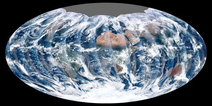
From 512 miles (824 kilometers) above Earth, the Visible Infrared Imager Radiometer Suite (VIIRS) on the NPOESS Preparatory Project (NPP) satellite gets a complete view of Earth every day. The above image from Nov. 24 is the first complete global image from VIIRS.
NPP is the first satellite designed to collect data for both weather forecasting and climate monitoring. It will also lay the foundation for more advanced Earth-observing craft, scientists say.
Latest Videos From
The NPP satellite launched on Oct. 28 and VIIRS acquired its first measurements on Nov. 21. The images are preliminary and are used to gauge the health of the sensor as engineers continue to power it up for full operation.
Last month, the satellite sent back its first look at the Earth and took a nice close-up of the U.S. East Coast.
NPP has now reached its final orbit, powered on all instruments and is traveling around the Earth at 16,640 mph (26,780 kph).
Rising from the south and setting in the north on the daylight side of Earth, VIIRS images the surface in long wedges measuring 1,900 miles (3,000 km) across. The swaths from each successive orbit overlap one another, so that at the end of the day, the sensor has a complete view of the globe. The Arctic is missing because it is too dark to view in visible light during the winter.
The NPP satellite was placed in a sun-synchronous orbit, a unique path that takes the satellite over the equator at the same local (ground) time in every orbit. So, when NPP flies over Kenya, it is about 1:30 p.m. on the ground. When NPP reaches Gabon — about 1,900 miles to the west — on the next orbit, it is close to 1:30 p.m. on the ground. This orbit allows the satellite to maintain the same angle between Earth and the sun so that all images have similar lighting.
The consistent lighting is evident in the daily global image. Stripes of sunlight (sunglint) reflect off the ocean in the same place on the left side of every swath. The consistent angle is important because it allows scientists to compare images from year to year without worrying about extreme changes in shadows and lighting.
The image also shows a band of haze along the right side of every orbit swath. When light travels through the atmosphere, it bounces off particles or scatters, making the atmosphere look hazy. The scattering effect is most pronounced along the edge of the swath, where the sensor is looking at an angle through more of the atmosphere.
Once VIIRS begins full operations, it will produce a range of measurements, from ocean temperature to clouds to the locations of fires.
Follow OurAmazingPlanet for the latest in Earth science and exploration news on Twitter @OAPlanet and on Facebook.