Our amazing planet.

The Mississippi River Valley In 3D

mississippi-river-valley-3d-110519
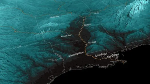
The Mississippi River Valley. (Image credit: NOAA.)

This image shows the Mississippi flood plain in 3D, the low-lying areas forming a broad area on the Louisiana and Mississippi sides of the river.

The dark, low-lying areas are bracing for or battling against historic flooding along the Mississippi River and its tributaries. These bodies of water have crested in some areas while other areas finish final preparations to secure property and evacuate. [Images: Before & After the 2011 Mississippi Floods ]

The data for this visualization comes from the Shuttle Radar Topography Mission carried out by the space shuttle Endeavour during an 11-day mission in February 2000.

A cornerstone of Endeavour's scientific legacy, this mission created the most complete high-resolution digital topographic database of Earth. These digital elevation models are used by NOAA in many products such as coastal inundation, tsunami modeling and evacuation planning.

Live Science Staff
For the science geek in everyone, Live Science offers a fascinating window into the natural and technological world, delivering comprehensive and compelling news and analysis on everything from dinosaur discoveries, archaeological finds and amazing animals to health, innovation and wearable technology. We aim to empower and inspire our readers with the tools needed to understand the world and appreciate its everyday awe.