
 Live Science Plus


Fresh Batch of Cold Air Set to Invade Midwest, Northeast
This article was provided by AccuWeather.com.
The temperature roller coaster is set to head down the tracks ... again.
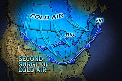
A strong cold front will plunge south through the northern Plains and Upper Midwest today, eventually clearing the Great Lakes, Ohio Valley and interior Northeast Friday.

While it may be the third cold front in the past week for most areas, this one certainly looks to be the strongest. In fact, some locales will experience their first accumulating snow of the season, while others are slated for a killing freeze.
Temperatures will be about 10 degrees cooler in the wake of the front, equating to 40s and 50s during the daytime hours, and 20s and 30s at night.
A wave of low pressure riding along the front will spread a swath of snow from the northern Great Lakes across southern Canada and even into parts of New England through early Friday.
AccuWeather.com Expert Senior Meteorologist Alex Sosnowski hinted at the possibility of this a few days ago.
Get the world’s most fascinating discoveries delivered straight to your inbox.
Most of the accumulating snow should remain across southern parts of Ontario and Quebec, but a slushy coating isn't out of the question across the U.P. of Michigan and higher elevations of New England.
Perhaps the most enduring aspect of the cold blast will be a killing, hard freeze that will likely end the growing season Friday night from the central Appalachians through much of New England.

"The risk of garden-ruining temperatures could reach the northern and western suburbs of Washington, D.C., Baltimore, Philadelphia, New York City and Boston, as well as some of the normally colder spots south and east of these cities," said Sosnowski.
While the snow and chill will signal a sign of what's to come this winter, the cooler temperatures will only last for about a day before the temperatures head back up.
A spell of milder air can be expected this weekend through next week, putting the kibosh on the threat for more snow and freezing temperatures for the time being.
© AccuWeather.com. All rights reserved. More from AccuWeather.com.
The only sure thing about weather forecasts is that they’re wildly different all over the planet. Test your knowledge on the wild ranges in temperature, precipitation and more.
Extreme Weather Facts: Quiz Yourself
