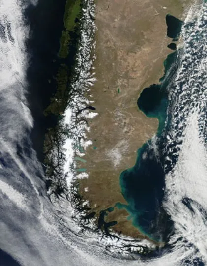
NASA's Terra satellite captured this striking image of springtime in Patagonia, the mountainous region at the tip of South America, on Sept. 24.
Patagonia comprises parts of Chile and Argentina. Although there are no borders overlaid on the image, Chile lies roughly to the west of the Andes Mountains, which run from north to south and are snow-capped in this image.
One of the most stunning features along the Andes is a series of bright blue glacial lakes. The southernmost portion of this mountain range remains quite cold year-round, and is home to vast glaciers and the Southern Patagonian Icefield.
Latest Videos From
Moving east from the towering Andes the land gives way to enormous plains, while in the west the land is covered in green foliage, even in early spring. (While fall is in full swing in the Northern Hemisphere, it is spring in the Southern Hemisphere.)
Springtime in Patagonia, like spring in most places, is a time of change and rebirth. Many wildflowers bloom, including a stark red plant known as the Chilean firebush. Flocks of migrating birds cross the land. By November, about 150,000 Magellanic penguins will return to the Chilean coast to raise their young. Spring is also the time for the birth of baby guanacos, a llama-like species found in Patagonia.
Reach Douglas Main at dmain@techmedianetwork.com. Follow him on Twitter @Douglas_Main. Follow OurAmazingPlanet on Twitter @OAPlanet. We're also on Facebook and Google+.

 Live Science Plus