It's quick and easy to access Live Science Plus, simply enter your email below. We'll send you a confirmation and sign you up for our daily newsletter, keeping you up to date with the latest science news.
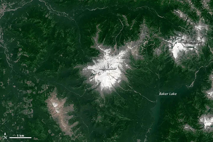
New photos taken from space show the significant snow loss this year atop Mount Baker, in Washington state.
The mountain sits about 15 miles (25 kilometers) south of the Canadian border and 85 miles (135 km) northeast of Seattle. The steep, cone-shaped volcano rises 10,780 feet (3,286 meters) above sea level, making it the highest peak in the North Cascades.
A camera on NASA's satellite Landsat 8 captured a photograph on July 9 showing snow cover of about 17 square miles (45 square kilometers) atop the mountain. A previous photo, taken July 3, 2013, by the same satellite, shows that the snow cover then extended 47 square miles (123 square kilometers).
Although precipitation levels in the Pacific Northwest this winter and spring were average, or only slightly below average, much of the precipitation fell as rain, instead of the usual snow. Peaks throughout Washington's Cascade and Olympic ranges saw sparser snowpack this year, and the snow that was there melted more quickly than usual, according to NASA.
The Glaciers on Mount Baker have also retreated over the past decade, according to a 2012 paper published in the journal Hydrological Processes.
The steep sides of Mount Baker host the largest contiguous section of glaciers in the North Cascades. In 1958, these glaciers stretched more than 20 square miles (51 square km), but in 2012, they covered 15 square miles (39 square km).
The lack of snow on Mount Baker and other peaks of the Pacific Northwest can affect the region's wildlife, fire risk and agriculture. Although rainfall has kept some reservoirs filled, the reservoirs that rely on snowmelt-fed streams will be drier during more arid months, according to NASA.
Sign up for the Live Science daily newsletter now
Get the world’s most fascinating discoveries delivered straight to your inbox.
Aerial view of Mount Baker in Washington captured on July 3, 2013 using Operational Land Imager on satellite Landsat 8.
(Image credit: Joshua Stevens, NASA Earth Observatory)
Mount Baker is one of the youngest volcanoes in the Cascade Range. It started erupting about a million years ago, although evidence from its earliest eruptions eroded as its glaciers slowly scraped the volcanic rocks away, according to the USGS.
Elizabeth is a staff writer for Live Science. She enjoys learning and writing about natural and health sciences, and is thrilled when she finds an evocative metaphor for an obscure scientific idea. She researched ancient iron formations in China for her Masters of Science degree in Geosciences at the University of California, Riverside, and went on to Columbia Journalism School for a master's degree in journalism, focusing on environmental and science writing.

 Live Science Plus