Live Science Plus


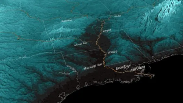
The Mississippi River Valley In 3D
You are now subscribed
Your newsletter sign-up was successful
Want to add more newsletters?

Delivered Daily
Daily Newsletter
Sign up for the latest discoveries, groundbreaking research and fascinating breakthroughs that impact you and the wider world direct to your inbox.

Once a week
Life's Little Mysteries
Feed your curiosity with an exclusive mystery every week, solved with science and delivered direct to your inbox before it's seen anywhere else.

Once a week
How It Works
Sign up to our free science & technology newsletter for your weekly fix of fascinating articles, quick quizzes, amazing images, and more

Delivered daily
Space.com Newsletter
Breaking space news, the latest updates on rocket launches, skywatching events and more!

Once a month
Watch This Space
Sign up to our monthly entertainment newsletter to keep up with all our coverage of the latest sci-fi and space movies, tv shows, games and books.

Once a week
Night Sky This Week
Discover this week's must-see night sky events, moon phases, and stunning astrophotos. Sign up for our skywatching newsletter and explore the universe with us!
Join the club
Get full access to premium articles, exclusive features and a growing list of member rewards.
This image shows the Mississippi flood plain in 3D, the low-lying areas forming a broad area on the Louisiana and Mississippi sides of the river.
The dark, low-lying areas are bracing for or battling against historic flooding along the Mississippi River and its tributaries. These bodies of water have crested in some areas while other areas finish final preparations to secure property and evacuate. [Images: Before & After the 2011 Mississippi Floods ]
A cornerstone of Endeavour's scientific legacy, this mission created the most complete high-resolution digital topographic database of Earth. These digital elevation models are used by NOAA in many products such as coastal inundation, tsunami modeling and evacuation planning.