














Weakened Tropical Storm Ophelia Could Make a Comeback

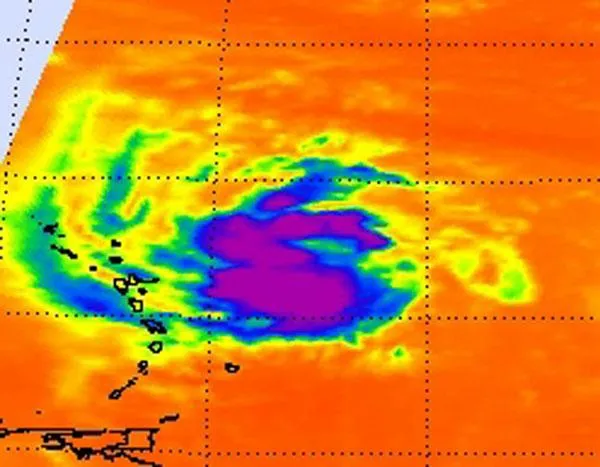
Tropical Storm Ophelia weakened below tropical storm status last Sunday (Sept. 25), but its remnants have remained over the Atlantic Ocean, Now, satellites are seeing signs that these remnants could re-strengthen into a tropical cyclone (the collective term for tropical storms and hurricanes).
NASA infrared satellite imagery takes temperatures of cloud heights and sea surface temperatures -- two big factors that meteorologists take into account with tropical cyclone development. Warm ocean surface temperatures over 80 degrees Fahrenheit (26.6 degrees Celsius) are needed to maintain and power a tropical cyclone. High, very cold cloud top temperatures indicate the storm has a strong uplift to create more thunderstorms that make up a tropical storm.
The Atmospheric Infrared Sounder (AIRS) instrument on NASA's Aqua satellite showed that those warm temperatures exist today where Ophelia's remnants are located, east of the Northern Antilles. That means a power source to strengthen is there.
Also potentially helping the storm to heat back up: Wind shear has died down, as the National Hurricane Center expected, so Ophelia is no longer being battered as it was over the last couple of days.
Infrared data captured by AIRS showed the coldest temperatures and strongest thunderstorms (and heaviest rainfall) were located west and south of the center of the low pressure area's circulation. Those cloud top temperatures were colder than minus 63 F (minus 52 C) indicating they were high, strong thunderstorms. Satellite image also show that the low appears to have a large circulation.
Ophelia's remnants are sitting a couple of hundred miles east-northeast of the Northern Leeward Islands today. They are producing a large area of showers and thunderstorms. The low will continue moving slowly to the northwest, and according to the National Hurricane Center, Ophelia has a high chance, near 80 percent, of being reborn.
Ophelia was the 15th named storm of the 2011 season, followed by number 16, Tropical Storm Phillipe. The 2011 season was predicted to be a doozy, with 14 to 19 named storms (which include tropical storms and hurricanes), seven to 10 hurricanes and three to five major hurricanes (Category 3 or higher). So far there have been 16 named storms, three hurricanes (Irene, Katia and Maria) and two major hurricanes (Irene and Katia).
Get the world’s most fascinating discoveries delivered straight to your inbox.
